TopoQuest Logo
Do you find TopoQuest useful?
Help keep TopoQuest running and adding new maps/features by donating!
Bitcoin:  19c7KJd3qBynnjoSw5npx9KScwjBe4ifkT
Litecoin:  LXs6TkuXGGXo1vDsWCkWVdjQX94eUKd6ui
Home View Maps Find Maps Find Places Resources & Links


Mount Carroll, Illinois Topographic Map

USGS Map Title: Mount Carroll, IL
USGS Map MRC: 42089A8
DRG (GeoTIFF) Download: o42089a8.tif


Neighboring USGS Topographic Map Quads:


  Pleasant Valley, IL  
42090B1
 

  Loran, IL  
42089B8
 

  Boone Branch, IL  
42089B7
 

  Wacker, IL  
42090A1
 

  Mount Carroll, IL  
42089A8
 

  Lanark, IL  
42089A7
 

  Thomson, IL  
41090H1
 

  Fair Haven, IL  
41089H8
 

  Milledgeville, IL  
41089H7


Map MRC Location:

N43°
W90°
N43°
W89°
H8 H7 H6 H5 H4 H3 H2 H1
G8 G7 G6 G5 G4 G3 G2 G1
F8 F7 F6 F5 F4 F3 F2 F1
E8 E7 E6 E5 E4 E3 E2 E1
D8 D7 D6 D5 D4 D3 D2 D1
C8 C7 C6 C5 C4 C3 C2 C1
B8 B7 B6 B5 B4 B3 B2 B1
A8 A7 A6 A5 A4 A3 A2 A1
N42°
W90°
N42°
W89°

Mount Carroll, IL USGS 1:24K Topographic Map Preview:
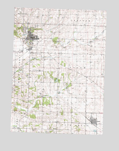
Mount Carroll, IL USGS Topographic Map
Click on map above to begin viewing in our Map Viewer.

This topographic map contains these locations and features:
Feature Name Type Latitude Longitude GNIS ID View Map
Adams-Daggert CemeteryCemeteryN42.0378°W89.9585°1785393View Map
Ashdale JunctionPopulated PlaceN42.0850°W89.9246°422418View Map
Black Oak ChurchChurchN42.0120°W89.9371°404494View Map
Black Oak Lutheran CemeteryCemeteryN42.0122°W89.9373°1785400View Map
Carroll CountyCivilN42.0687°W89.9344°424209View Map
Carroll County Farm (historical)LocaleN42.0717°W89.9857°1785404View Map
Carroll County Sheriff's OfficeBuildingN42.1007°W89.9783°2756950View Map
ChadwickPopulated PlaceN42.0134°W89.8907°405920View Map
Chadwick Fire Protection DistrictBuildingN42.0137°W89.8899°2640423View Map
Chadwick Junior High SchoolSchoolN42.0100°W89.8832°1785406View Map
Chadwick Police DepartmentBuildingN42.0140°W89.8905°2757052View Map
Chadwick Post OfficePost OfficeN42.0139°W89.8911°2788740View Map
City of Mount CarrollCivilN42.0948°W89.9769°2395121View Map
Daggett (historical)Populated PlaceN42.0325°W89.9737°422600View Map
Daggett School (historical)SchoolN42.0431°W89.9585°406921View Map
Emerson School (historical)SchoolN42.0036°W89.9465°407998View Map
Fairground School (historical)SchoolN42.0820°W89.9912°408171View Map
Fairview School (historical)SchoolN42.1234°W89.9876°408236View Map
Ferrin School (historical)SchoolN42.0536°W89.9962°408342View Map
First Baptist ChurchChurchN42.0970°W89.9793°1983899View Map
First Lutheran ChurchChurchN42.0959°W89.9785°1983900View Map
Hope Brethern Cemetery CemeteryCemeteryN42.0117°W89.9176°410506View Map
Hope United Methodist ChurchChurchN42.0120°W89.8879°1983892View Map
Kingery School (historical)SchoolN42.0800°W89.9523°411502View Map
Mission Ridge School (historical)SchoolN42.0506°W89.8990°413676View Map
Mount CarrollPopulated PlaceN42.0950°W89.9782°413953View Map
Mount Carroll AmbulanceBuildingN42.0926°W89.9757°2673916View Map
Mount Carroll Fire Protection DistrictBuildingN42.0950°W89.9773°2640717View Map
Mount Carroll High SchoolSchoolN42.0909°W89.9768°1785427View Map
Mount Carroll Historic DistrictParkN42.0947°W89.9776°1785428View Map
Mount Carroll Police DepartmentBuildingN42.1006°W89.9791°2756845View Map
Mount Carroll Post OfficePost OfficeN42.1002°W89.9775°1785429View Map
Mount Carroll United Methodist ChurchChurchN42.0961°W89.9787°1983901View Map
Oak Hill CemeteryCemeteryN42.1033°W89.9862°1785432View Map
Oakville CemeteryCemeteryN42.0492°W89.9262°1785434View Map
Oakville School (historical)SchoolN42.0484°W89.9260°414922View Map
Pleasant Hill School (historical)SchoolN42.0036°W89.9187°415865View Map
Straddle CreekStreamN42.0903°W89.8990°424167View Map
Tautz AirportAirportN42.0623°W89.9634°427578View Map
Timber LakeReservoirN42.0530°W89.9402°1692023View Map
Timber Lake DamDamN42.0522°W89.9410°1692022View Map
Township of SalemCivilN42.0647°W89.9175°429701View Map
Trinity Evangelical Lutheran CemeteryCemeteryN42.0506°W89.9590°1785450View Map
Trinity Lutheran ChurchChurchN42.0503°W89.9582°419865View Map
Village of ChadwickCivilN42.0142°W89.8884°2397595View Map
Vinegar Hill School (historical)SchoolN42.0161°W89.9860°420323View Map
Williard Nycum RLA Airport (historical)AirportN42.0986°W89.9515°427579View Map

Note: Coordinates in the location and feature list above are referenced to NAD83 datum.


Copyright (C) 2008-2024 Ryan Niemi / Sunset Dynamics ... All Rights Reserved