TopoQuest Logo
Do you find TopoQuest useful?
Help keep TopoQuest running and adding new maps/features by donating!
Bitcoin:  19c7KJd3qBynnjoSw5npx9KScwjBe4ifkT
Litecoin:  LXs6TkuXGGXo1vDsWCkWVdjQX94eUKd6ui
Home View Maps Find Maps Find Places Resources & Links


Mount Baldy, California Topographic Map

USGS Map Title: Mount Baldy, CA
USGS Map MRC: 34117B6
DRG (GeoTIFF) Download: o34117b6.tif


Neighboring USGS Topographic Map Quads:


  Crystal Lake, CA  
34117C7
 

  Mount San Antonio, CA  
34117C6
 

  Telegraph Peak, CA  
34117C5
 

  Glendora, CA  
34117B7
 

  Mount Baldy, CA  
34117B6
 

  Cucamonga Peak, CA  
34117B5
 

  San Dimas, CA  
34117A7
 

  Ontario, CA  
34117A6
 

  Guasti, CA  
34117A5


Map MRC Location:

N35°
W118°
N35°
W117°
H8 H7 H6 H5 H4 H3 H2 H1
G8 G7 G6 G5 G4 G3 G2 G1
F8 F7 F6 F5 F4 F3 F2 F1
E8 E7 E6 E5 E4 E3 E2 E1
D8 D7 D6 D5 D4 D3 D2 D1
C8 C7 C6 C5 C4 C3 C2 C1
B8 B7 B6 B5 B4 B3 B2 B1
A8 A7 A6 A5 A4 A3 A2 A1
N34°
W118°
N34°
W117°

Mount Baldy, CA USGS 1:24K Topographic Map Preview:
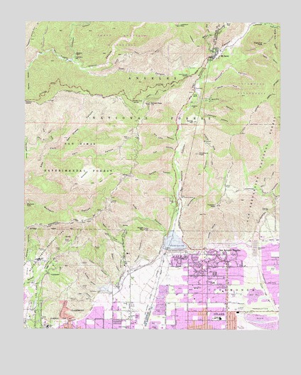
Mount Baldy, CA USGS Topographic Map
Click on map above to begin viewing in our Map Viewer.

This topographic map contains these locations and features:
Feature Name Type Latitude Longitude GNIS ID View Map
Alta Loma Christian ChurchChurchN34.1381°W117.6251°1841805View Map
Barrett CanyonValleyN34.2181°W117.6653°269687View Map
Bear CanyonValleyN34.2381°W117.6598°269721View Map
Browns FlatFlatN34.1881°W117.7220°270036View Map
Burbank CanyonValleyN34.1414°W117.7137°270082View Map
Cascade CanyonValleyN34.2156°W117.6698°270327View Map
Cat CanyonValleyN34.1975°W117.6773°270348View Map
Cherry CanyonValleyN34.2364°W117.6434°270401View Map
Chicken CanyonValleyN34.1500°W117.6992°270409View Map
City of ClaremontCivilN34.1259°W117.7153°2409465View Map
Cobal CanyonValleyN34.1433°W117.7092°270516View Map
Coldwater CanyonValleyN34.2342°W117.7278°270555View Map
Coldwater Canyon Truck TrailTrailN34.2319°W117.7067°277247View Map
Confluence ParkParkN34.1392°W117.6301°1841813View Map
Cow CanyonValleyN34.2297°W117.7220°270641View Map
Cow Canyon SaddleGapN34.2281°W117.6714°270643View Map
CucamongaCivilN34.1422°W117.6295°270701View Map
Cucamonga CanyonValleyN34.1614°W117.6376°270702View Map
Cucamonga Guard Station (historical)LocaleN34.1642°W117.6353°1701227View Map
Dells (historical)Populated PlaceN34.2392°W117.6537°1701194View Map
Desilting Basin 3 87-002 DamDamN34.1383°W117.6376°1663552View Map
Desilting Basin G 87-003 DamDamN34.1283°W117.6342°1663553View Map
Dry Lake CanyonValleyN34.2025°W117.6770°270928View Map
Evey CanyonValleyN34.1628°W117.6823°271087View Map
Fallen Leaf SpringSpringN34.2176°W117.6981°271096View Map
Falling Rock CanyonValleyN34.2486°W117.6289°271097View Map
Fern CanyonValleyN34.1956°W117.7392°271118View Map
Fern Canyon TrailTrailN34.2025°W117.7006°277249View Map
Fir DrawValleyN34.2481°W117.6264°271136View Map
Fire Station ParkParkN34.1367°W117.6601°1841810View Map
Forked Spruce SpringSpringN34.2228°W117.6876°1802866View Map
Frankish CanyonValleyN34.1611°W117.6601°271198View Map
Frankish PeakSummitN34.1756°W117.6570°271199View Map
Gail CanyonValleyN34.1358°W117.7176°271258View Map
Girls Collegiate SchoolSchoolN34.1253°W117.6995°271302View Map
Higginbotham ParkParkN34.1272°W117.7248°1723691View Map
Hog BackSummitN34.2203°W117.6687°1660753View Map
Icehouse CanyonValleyN34.2467°W117.6426°271701View Map
Jaeger ParkParkN34.1317°W117.7134°1723696View Map
KAGL-TV (San Bernardino)TowerN34.1875°W117.7003°1665169View Map
KDOC-TV (Anaheim)TowerN34.1872°W117.7012°1665147View Map
Kerkoff CanyonValleyN34.2256°W117.6653°271874View Map
KRCA-TV (Riverside)TowerN34.1878°W117.6995°1665163View Map
KSCI-TV (San Bernardino)TowerN34.1875°W117.6992°1665170View Map
La Puerta Sports ParkParkN34.1278°W117.7184°1723700View Map
Live Oak Canyon DamDamN34.1333°W117.7453°272139View Map
Lookout MountainSummitN34.2486°W117.6762°272205View Map
Los Angeles County Fire Department Station 62BuildingN34.1363°W117.7077°2105672View Map
Lower San Antonio StationLocaleN34.1786°W117.6753°272263View Map
Marshall CanyonValleyN34.1528°W117.7489°272360View Map
Marshall Canyon Golf CourseLocaleN34.1481°W117.7489°1723720View Map
Marshall Canyon Regional ParkParkN34.1547°W117.7406°272361View Map
Monta Vista Resort (historical)LocaleN34.1542°W117.6467°1701228View Map
Mount BaldyPopulated PlaceN34.2361°W117.6601°1660300View Map
Mount Baldy Elementary SchoolSchoolN34.2383°W117.6578°1841814View Map
Mount Baldy Forest Service FacilityLocaleN34.2389°W117.6548°277251View Map
Mount Baldy Visitor Information StationLocaleN34.2375°W117.6553°277252View Map
Mt Baldy Post OfficePost OfficeN34.2367°W117.6587°27833560View Map
North Fork Barrett CanyonValleyN34.2189°W117.6609°272673View Map
Padua Hills TheaterBuildingN34.1508°W117.7020°272838View Map
Palmer CanyonValleyN34.1439°W117.7078°247148View Map
Pepper Tree Elementary SchoolSchoolN34.1292°W117.6671°1841812View Map
Pioneer Junior High SchoolSchoolN34.1292°W117.6542°273020View Map
Pioneer ParkParkN34.1297°W117.6576°1841809View Map
Potato MountainSummitN34.1656°W117.6926°1661257View Map
Saint George Orthodox ChurchChurchN34.1389°W117.6722°2084798View Map
San Antonio CanyonValleyN34.1600°W117.6778°273431View Map
San Antonio DamDamN34.1575°W117.6781°273435View Map
San Antonio HeightsPopulated PlaceN34.1556°W117.6564°1661373View Map
San Antonio Heights Census Designated PlaceCensusN34.1570°W117.6589°2409248View Map
San Antonio Heights Community ChurchChurchN34.1567°W117.6564°2084799View Map
San Antonio ParkParkN34.1511°W117.6720°1841811View Map
San Bernardino County Fire Department Station 12 UplandBuildingN34.1512°W117.6514°2665067View Map
San Bernardino County Fire Department Station 200 - Mount BaldlyBuildingN34.2368°W117.6587°2665046View Map
Scudder Oaks SchoolSchoolN34.1300°W117.6995°273619View Map
Spring HillSummitN34.2095°W117.6689°273870View Map
Spruce CanyonValleyN34.1881°W117.6764°273872View Map
Stoddard CanyonValleyN34.1733°W117.6745°273907View Map
Stoddard FlatFlatN34.2011°W117.6617°273908View Map
Stoddard PeakSummitN34.1964°W117.6659°273909View Map
Sugarloaf PeakSummitN34.2417°W117.6348°273938View Map
Sunset PeakSummitN34.2167°W117.6903°273970View Map
Sunset Peak LookoutLocaleN34.2167°W117.6895°277248View Map
Sycamore Canyon ParkParkN34.1320°W117.7248°1723759View Map
Thompson CreekStreamN34.1272°W117.7306°274113View Map
Thompson Creek DamDamN34.1400°W117.7114°274115View Map
Thompson FlatFlatN34.2350°W117.7278°274116View Map
Thompson RanchLocaleN34.2369°W117.7264°274118View Map
Upland Fire Department Station 162BuildingN34.1376°W117.6605°2664850View Map
Upland Fire Department Station 164BuildingN34.1298°W117.6426°2664852View Map
Vail ParkParkN34.1275°W117.7017°1723764View Map
Valencia Elementary SchoolSchoolN34.1437°W117.6576°274299View Map
Webb SchoolSchoolN34.1258°W117.7389°274404View Map
West Cucamonga Truck TrailTrailN34.1820°W117.6367°274424View Map
West Fork Bear CanyonValleyN34.2450°W117.6620°274428View Map
West Fork Palmer CanyonValleyN34.1597°W117.7031°274440View Map
West Fork TrailTrailN34.1864°W117.6309°274446View Map
Williams CanyonValleyN34.1478°W117.7048°274503View Map
Wolfskill FallsFallsN34.1758°W117.7495°274564View Map

Note: Coordinates in the location and feature list above are referenced to NAD83 datum.


Copyright (C) 2008-2024 Ryan Niemi / Sunset Dynamics ... All Rights Reserved