TopoQuest Logo
Do you find TopoQuest useful?
Help keep TopoQuest running and adding new maps/features by donating!
Bitcoin:  19c7KJd3qBynnjoSw5npx9KScwjBe4ifkT
Litecoin:  LXs6TkuXGGXo1vDsWCkWVdjQX94eUKd6ui
Home View Maps Find Maps Find Places Resources & Links


Morrisville, New York Topographic Map

USGS Map Title: Morrisville, NY
USGS Map MRC: 42075H6
DRG (GeoTIFF) Download: o42075h6.tif


Neighboring USGS Topographic Map Quads:


  Canastota, NY  
43075A7
 

  Oneida, NY  
43075A6
 

  Vernon, NY  
43075A5
 

  Cazenovia, NY  
42075H7
 

  Morrisville, NY  
42075H6
 

  Munnsville, NY  
42075H5
 

  Erieville, NY  
42075G7
 

  West Eaton, NY  
42075G6
 

  Hamilton, NY  
42075G5


Map MRC Location:

N43°
W76°
N43°
W75°
H8 H7 H6 H5 H4 H3 H2 H1
G8 G7 G6 G5 G4 G3 G2 G1
F8 F7 F6 F5 F4 F3 F2 F1
E8 E7 E6 E5 E4 E3 E2 E1
D8 D7 D6 D5 D4 D3 D2 D1
C8 C7 C6 C5 C4 C3 C2 C1
B8 B7 B6 B5 B4 B3 B2 B1
A8 A7 A6 A5 A4 A3 A2 A1
N42°
W76°
N42°
W75°

Morrisville, NY USGS 1:24K Topographic Map Preview:
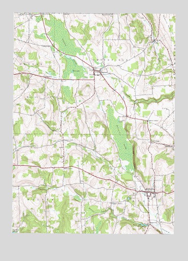
Morrisville, NY USGS Topographic Map
Click on map above to begin viewing in our Map Viewer.

This topographic map contains these locations and features:
Feature Name Type Latitude Longitude GNIS ID View Map
Automotive Performance CenterBuildingN42.8889°W75.6394°2563978View Map
Automotive Technology BuildingBuildingN42.8911°W75.6394°2563979View Map
Bailey AnnexBuildingN42.8978°W75.6406°2563955View Map
Bailey HallBuildingN42.8981°W75.6403°2563954View Map
Bicknell HallBuildingN42.8981°W75.6417°2563951View Map
Bliss CemeteryCemeteryN42.9044°W75.6969°2542861View Map
Bliss CornersLocaleN42.9417°W75.6621°944259View Map
Brooks HallBuildingN42.8992°W75.6417°2563957View Map
Bucks CornersLocaleN42.9123°W75.7102°945085View Map
Butcher LibraryBuildingN42.8939°W75.6406°2563958View Map
Callahan BrookStreamN42.8798°W75.6371°945470View Map
Campbell LakesLakeN42.9398°W75.6684°945704View Map
Cayuga HallBuildingN42.8947°W75.6400°2563974View Map
Charlton HallBuildingN42.8964°W75.6417°2563976View Map
Chenango ValleyValleyN42.9084°W75.6607°973319View Map
Cloverdale Farm AirportAirportN42.9941°W75.7046°2443692View Map
Crawford HallBuildingN42.8939°W75.6394°2563960View Map
Crouse Community Center Nursing HomeBuildingN42.8922°W75.6371°2598901View Map
Davis CornersLocaleN42.9270°W75.6432°948058View Map
Davis Corners CemeteryCemeteryN42.9340°W75.6437°2542863View Map
EaglevillePopulated PlaceN42.8815°W75.6435°948950View Map
East HallBuildingN42.8975°W75.6400°2563971View Map
Edward R Andrews Elementary SchoolSchoolN42.8955°W75.6443°2597828View Map
Eisaman CornersLocaleN42.9998°W75.6735°949442View Map
Eisaman Corners CemeteryCemeteryN42.9985°W75.6740°2542866View Map
Electric Light PondReservoirN42.8802°W75.6481°949467View Map
Electric Light StreamStreamN42.8795°W75.6368°949468View Map
Embury CornersLocaleN42.9392°W75.6460°949625View Map
Faith Baptist ChurchChurchN42.9010°W75.6527°2597853View Map
Fountain View HallBuildingN42.8939°W75.6372°2563961View Map
Galbreath HallBuildingN42.8967°W75.6400°2563977View Map
Gills CornersLocaleN42.9248°W75.6257°951133View Map
Hamilton HallBuildingN42.8975°W75.6419°2563970View Map
Helyar HallBuildingN42.8942°W75.6378°2563963View Map
Hughes CornersLocaleN42.9273°W75.7110°953407View Map
IcePlexBuildingN42.8914°W75.6431°2563980View Map
Madison CountyCivilN42.9128°W75.6697°974125View Map
Madison HallBuildingN42.8981°W75.6414°2563952View Map
Marshall HallBuildingN42.8958°W75.6400°2563969View Map
Miller LakeLakeN42.9667°W75.7046°957316View Map
Mohawk HallBuildingN42.8950°W75.6392°2563966View Map
MorrisvillePopulated PlaceN42.8987°W75.6402°957706View Map
Morrisville - Eaton Middle and High SchoolSchoolN42.9438°W75.6598°2597839View Map
Morrisville Community ChurchChurchN42.9071°W75.6526°2597866View Map
Morrisville Fire DepartmentBuildingN42.8984°W75.6434°2718527View Map
Morrisville Post OfficePost OfficeN42.8982°W75.6463°2598890View Map
Morrisville Public LibraryBuildingN42.8989°W75.6427°2598915View Map
Morrisville Rural CemeteryCemeteryN42.9018°W75.6500°2542862View Map
Morrisville State CollegeSchoolN42.8958°W75.6417°2547763View Map
Morrisville SwampSwampN42.9277°W75.6661°957708View Map
Morrisville Village Wastewater Treatment PlantLocaleN42.8929°W75.6490°2597241View Map
Mutton HillSummitN42.9526°W75.7394°958218View Map
Oneida HallBuildingN42.8956°W75.6394°2563973View Map
Onondaga HallBuildingN42.8942°W75.6394°2563967View Map
PeterboroPopulated PlaceN42.9673°W75.6880°960231View Map
Peterboro CemeteryCemeteryN42.9710°W75.6769°2542864View Map
Peterboro Post OfficePost OfficeN42.9674°W75.6858°2599212View Map
Peterboro SwampSwampN42.9795°W75.7085°960232View Map
Peterboro Village CemeteryCemeteryN42.9703°W75.6897°2542865View Map
Richardson Family FarmLocaleN42.8914°W75.6989°2547249View Map
Roberts CemeteryCemeteryN42.9984°W75.7337°962648View Map
Roberts CornersLocaleN42.9998°W75.7294°962650View Map
School Number 2 (historical)SchoolN42.9839°W75.6431°2353136View Map
School Number 3 (historical)SchoolN42.9637°W75.7252°975275View Map
School Number 6 (historical)SchoolN42.9992°W75.6739°2353137View Map
School Number 7 (historical)SchoolN42.9992°W75.7419°975553View Map
School Number 7 (historical)SchoolN42.9998°W75.7116°975554View Map
Seneca HallBuildingN42.8953°W75.6408°2563975View Map
Shannon HallBuildingN42.8958°W75.6414°2563972View Map
SiloamPopulated PlaceN42.9848°W75.6413°965231View Map
Siloam CemeteryCemeteryN42.9844°W75.6388°2542867View Map
Smithfield Eaton Volunteer AmbulanceBuildingN42.9005°W75.6488°2720204View Map
Smithfield Volunteer Fire DepartmentBuildingN42.9675°W75.6842°2735040View Map
South HallBuildingN42.8931°W75.6361°2563964View Map
Spader Horticulture ComplexBuildingN42.8944°W75.6408°2563968View Map
Stewart HallBuildingN42.8936°W75.6364°2563962View Map
Student Activities BuildingBuildingN42.8928°W75.6403°2563956View Map
Swamp SchoolSchoolN42.9809°W75.7221°966878View Map
The LedgesCliffN42.9184°W75.6566°967282View Map
Town of EatonCivilN42.8814°W75.6290°978923View Map
Town of SmithfieldCivilN42.9689°W75.6726°979497View Map
Village of MorrisvilleCivilN42.8987°W75.6448°2390998View Map
West HallBuildingN42.8933°W75.6369°2563965View Map
Westcott CemeteryCemeteryN42.9189°W75.7105°970906View Map
Whipple Administration BuildingBuildingN42.8936°W75.6397°2563953View Map
Williams CornersPopulated PlaceN42.8928°W75.6730°971308View Map
WJIW-AM (Cazenovia)TowerN42.9415°W75.7494°977587View Map
Wood Technology BuildingBuildingN42.8906°W75.6436°2563959View Map

Note: Coordinates in the location and feature list above are referenced to NAD83 datum.


Copyright (C) 2008-2024 Ryan Niemi / Sunset Dynamics ... All Rights Reserved