TopoQuest Logo
Do you find TopoQuest useful?
Help keep TopoQuest running and adding new maps/features by donating!
Bitcoin:  19c7KJd3qBynnjoSw5npx9KScwjBe4ifkT
Litecoin:  LXs6TkuXGGXo1vDsWCkWVdjQX94eUKd6ui
Home View Maps Find Maps Find Places Resources & Links


Morattico, Virginia Topographic Map

USGS Map Title: Morattico, VA
USGS Map MRC: 37076G6
DRG (GeoTIFF) Download: o37076g6.tif


Neighboring USGS Topographic Map Quads:


  Tappahannock, VA  
37076H7
 

  Haynesville, VA  
37076H6
 

  Lottsburg, VA  
37076H5
 

  Dunnsville, VA  
37076G7
 

  Morattico, VA  
37076G6
 

  Lively, VA  
37076G5
 

  Truhart, VA  
37076F7
 

  Church View, VA  
37076F6
 

  Urbanna, VA  
37076F5


Map MRC Location:

N38°
W77°
N38°
W76°
H8 H7 H6 H5 H4 H3 H2 H1
G8 G7 G6 G5 G4 G3 G2 G1
F8 F7 F6 F5 F4 F3 F2 F1
E8 E7 E6 E5 E4 E3 E2 E1
D8 D7 D6 D5 D4 D3 D2 D1
C8 C7 C6 C5 C4 C3 C2 C1
B8 B7 B6 B5 B4 B3 B2 B1
A8 A7 A6 A5 A4 A3 A2 A1
N37°
W77°
N37°
W76°

Morattico, VA USGS 1:24K Topographic Map Preview:
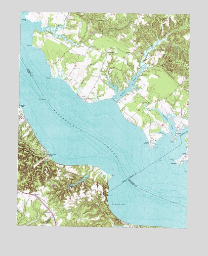
Morattico, VA USGS Topographic Map
Click on map above to begin viewing in our Map Viewer.

This topographic map contains these locations and features:
Feature Name Type Latitude Longitude GNIS ID View Map
BayportPopulated PlaceN37.7546°W76.6736°1495240View Map
Bowlers Ferry (historical)CrossingN37.8265°W76.7369°1739413View Map
Bowlers RockPillarN37.8237°W76.7272°1477992View Map
Bowlers Rock LighthouseLocaleN37.8240°W76.7325°1779052View Map
ButyloPopulated PlaceN37.7710°W76.6880°1477165View Map
Butylo BluffCliffN37.7718°W76.6863°1739416View Map
Canoe House LandingLocaleN37.7546°W76.6736°1739480View Map
Cedar CreekStreamN37.7863°W76.6966°1464595View Map
Cedar Creek DamDamN37.7751°W76.7080°1489650View Map
Cedar Creek Lower DamDamN37.7801°W76.6980°1489652View Map
Cedar Creek PondReservoirN37.7751°W76.7080°1489651View Map
Conley SwampStreamN37.8590°W76.6483°1465170View Map
Curletts PointCapeN37.7901°W76.6344°1465537View Map
Ebenezer ChurchChurchN37.8710°W76.6888°1466153View Map
Ebenezer School (historical)SchoolN37.8704°W76.6886°1791309View Map
Emmanuel CemeteryCemeteryN37.7937°W76.6255°1779010View Map
Emmanuel ChurchChurchN37.7935°W76.6255°1466288View Map
Farnham CreekStreamN37.8254°W76.6800°1466498View Map
Folly Neck AirportAirportN37.8692°W76.7324°2675643View Map
Garrett's MarinaHarborN37.8111°W76.7440°2520100View Map
Garretts LandingLocaleN37.7779°W76.6819°1739428View Map
Hatters CreekStreamN37.8282°W76.6777°1791319View Map
IvondalePopulated PlaceN37.8518°W76.6683°1477440View Map
Jones PointCapeN37.7799°W76.6805°1468853View Map
Lancaster CreekStreamN37.7974°W76.6330°1469117View Map
LaneviewPopulated PlaceN37.7588°W76.7247°1495815View Map
Laton SwampStreamN37.8604°W76.6430°1469151View Map
Layton LandingLocaleN37.7871°W76.7219°1739438View Map
Laytons BranchStreamN37.7899°W76.7247°1469223View Map
Mark Haven BeachLocaleN37.7907°W76.7252°1470094View Map
Marshall DamDamN37.8318°W76.6630°1490790View Map
Masons Mill SwampStreamN37.7518°W76.6652°1470170View Map
McKans BayBayN37.7751°W76.6663°1470267View Map
Milden CemeteryCemeteryN37.8287°W76.7038°1791330View Map
Milden Presbyterian ChurchChurchN37.8246°W76.7016°1791331View Map
Mill BranchStreamN37.7518°W76.6652°1470465View Map
MontaguePopulated PlaceN37.7682°W76.7375°1470684View Map
MoratticoPopulated PlaceN37.7893°W76.6291°1470728View Map
Morattico CreekStreamN37.8043°W76.6372°1470730View Map
Morattico Post OfficePost OfficeN37.7880°W76.6299°2767240View Map
Morattico SwampSwampN37.8193°W76.6535°1791333View Map
Myrtle SwampStreamN37.8274°W76.7080°1471302View Map
Neals PointCapeN37.8549°W76.7408°1471354View Map
Nimcock (historical)Populated PlaceN37.7826°W76.6936°1739449View Map
North Fork Richardson CreekStreamN37.8646°W76.7238°1474262View Map
Oakley LandingPopulated PlaceN37.7987°W76.6525°1496034View Map
Pearson IslandCapeN37.8018°W76.6344°1472159View Map
Perch CreekStreamN37.8062°W76.6383°1472200View Map
Richardson CreekStreamN37.8662°W76.7377°1473186View Map
School Number 5 (historical)SchoolN37.8479°W76.6869°1791350View Map
Shandy Hall FarmLocaleN37.8543°W76.7355°1791353View Map
Shandy Hall Farm AirportAirportN37.8566°W76.7361°1498844View Map
SharpsPopulated PlaceN37.8240°W76.7008°1474452View Map
Sharps Post OfficePost OfficeN37.8335°W76.6935°2767261View Map
Simons CornerPopulated PlaceN37.8521°W76.6863°1474612View Map
SimonsonPopulated PlaceN37.8068°W76.6336°1496229View Map
Snake IslandIslandN37.8271°W76.6769°1791355View Map
Suggetts PointCapeN37.8362°W76.7263°1475302View Map
Tarpley PointCapeN37.7960°W76.6513°1475480View Map
TidewaterPopulated PlaceN37.8551°W76.6986°1475706View Map
Totuskey CreekStreamN37.8735°W76.7480°1475798View Map
Waverly PointCapeN37.8707°W76.7458°1476402View Map
Whelan's MarinaHarborN37.7999°W76.6514°2520125View Map
Whelan's Marina CampgroundLocaleN37.8003°W76.6507°2520132View Map
Whilans MarinaLocaleN37.7996°W76.6497°1791362View Map
Wildwood BeachPopulated PlaceN37.8065°W76.7402°1739474View Map
Wildwood BeachBeachN37.8085°W76.7413°1477994View Map
Wilna PointCapeN37.8249°W76.6797°1476808View Map

Note: Coordinates in the location and feature list above are referenced to NAD83 datum.


Copyright (C) 2008-2024 Ryan Niemi / Sunset Dynamics ... All Rights Reserved