TopoQuest Logo
Do you find TopoQuest useful?
Help keep TopoQuest running and adding new maps/features by donating!
Bitcoin:  19c7KJd3qBynnjoSw5npx9KScwjBe4ifkT
Litecoin:  LXs6TkuXGGXo1vDsWCkWVdjQX94eUKd6ui
Home View Maps Find Maps Find Places Resources & Links


Lively, Virginia Topographic Map

USGS Map Title: Lively, VA
USGS Map MRC: 37076G5
DRG (GeoTIFF) Download: o37076g5.tif


Neighboring USGS Topographic Map Quads:


  Haynesville, VA  
37076H6
 

  Lottsburg, VA  
37076H5
 

  Heathsville, VA  
37076H4
 

  Morattico, VA  
37076G6
 

  Lively, VA  
37076G5
 

  Lancaster, VA  
37076G4
 

  Church View, VA  
37076F6
 

  Urbanna, VA  
37076F5
 

  Irvington, VA  
37076F4


Map MRC Location:

N38°
W77°
N38°
W76°
H8 H7 H6 H5 H4 H3 H2 H1
G8 G7 G6 G5 G4 G3 G2 G1
F8 F7 F6 F5 F4 F3 F2 F1
E8 E7 E6 E5 E4 E3 E2 E1
D8 D7 D6 D5 D4 D3 D2 D1
C8 C7 C6 C5 C4 C3 C2 C1
B8 B7 B6 B5 B4 B3 B2 B1
A8 A7 A6 A5 A4 A3 A2 A1
N37°
W77°
N37°
W76°

Lively, VA USGS 1:24K Topographic Map Preview:
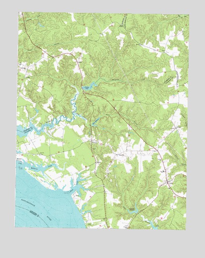
Lively, VA USGS Topographic Map
Click on map above to begin viewing in our Map Viewer.

This topographic map contains these locations and features:
Feature Name Type Latitude Longitude GNIS ID View Map
AlfonsoPopulated PlaceN37.8087°W76.5080°1462395View Map
Balls BranchStreamN37.8165°W76.5830°1462749View Map
Balls Mill (historical)LocaleN37.8107°W76.5700°1778987View Map
Balls MillpondReservoirN37.8117°W76.5671°1501945View Map
Balls Millpond DamDamN37.8104°W76.5694°1490242View Map
Belle IsleIslandN37.7788°W76.6077°1463042View Map
Bethel CemeteryCemeteryN37.7521°W76.5419°1778990View Map
Bethel ChurchChurchN37.7504°W76.5430°1463189View Map
Beulah CemeteryCemeteryN37.7901°W76.5183°1778991View Map
Beulah ChurchChurchN37.7904°W76.5186°1463272View Map
Blackmore Millpond DamDamN37.7599°W76.5352°1490244View Map
Blakemore MillpondReservoirN37.7601°W76.5367°1463549View Map
BoerPopulated PlaceN37.7696°W76.5825°1495282View Map
Bridgetown (historical)Populated PlaceN37.8104°W76.5425°1778994View Map
Bush School (historical)SchoolN37.8240°W76.5247°1778995View Map
Chinns DamDamN37.8315°W76.5769°1490784View Map
Chinns Mill (historical)LocaleN37.8312°W76.5775°1779002View Map
Chinns PondReservoirN37.8321°W76.5726°1464865View Map
Colbert PointCapeN37.7871°W76.6200°1465062View Map
Deep CreekStreamN37.7707°W76.5852°1465698View Map
District 4CivilN37.8744°W76.6006°1927252View Map
DowningsPopulated PlaceN37.8446°W76.6230°1465927View Map
FairplayPopulated PlaceN37.8374°W76.6194°1477315View Map
Foxs Mill DamDamN37.7599°W76.5352°1779011View Map
Griffins LandingPopulated PlaceN37.7515°W76.5222°1495624View Map
Hopewell CemeteryCemeteryN37.8568°W76.5352°1791321View Map
Hopewell ChurchChurchN37.8571°W76.5347°1468229View Map
Lanier-Davis DamDamN37.8168°W76.6097°1490792View Map
LaraPopulated PlaceN37.8529°W76.5175°1477473View Map
Lebanon CemeteryCemeteryN37.8096°W76.5091°1779020View Map
Lebanon ChurchChurchN37.8093°W76.5086°1469248View Map
LitwaltonPopulated PlaceN37.8010°W76.5697°1477495View Map
LivelyPopulated PlaceN37.7776°W76.5136°1495853View Map
Lively Post OfficePost OfficeN37.7784°W76.5143°2766468View Map
Lively SchoolSchoolN37.7837°W76.5163°1469706View Map
Maon Church (historical)ChurchN37.8682°W76.5483°1760819View Map
Marsh DamDamN37.8301°W76.5213°1490243View Map
Moon CornerPopulated PlaceN37.8685°W76.5477°1477552View Map
Morattico Old Mill PondReservoirN37.8332°W76.5674°1779026View Map
Mount Zion Baptist ChurchChurchN37.8449°W76.6122°1791336View Map
Mulberry CreekStreamN37.7860°W76.6191°1471247View Map
Norwood CemeteryCemeteryN37.7926°W76.6069°1779031View Map
Norwood ChurchChurchN37.7926°W76.6069°1471674View Map
NuttsvillePopulated PlaceN37.7935°W76.5508°1477583View Map
Nuttsville Post OfficePost OfficeN37.7930°W76.5510°2519640View Map
Pierces CornerPopulated PlaceN37.7960°W76.5438°1779035View Map
Pollards Mill (historical)LocaleN37.7593°W76.5363°1779036View Map
RobleyPopulated PlaceN37.8468°W76.5802°1477689View Map
SomersPopulated PlaceN37.7882°W76.5663°1477768View Map
Upper Lancaster Volunteer Fire DepartmentBuildingN37.7809°W76.5157°2086204View Map
Upper Lancaster Volunteer Rescue SquadBuildingN37.7769°W76.5120°2086166View Map
Upper Lancaster Volunteer Rescue SquadBuildingN37.7755°W76.5109°2331783View Map
Wells His CreekStreamN37.7585°W76.5769°1779045View Map
Woodhouse LandingLocaleN37.8110°W76.5861°1478012View Map

Note: Coordinates in the location and feature list above are referenced to NAD83 datum.


Copyright (C) 2008-2024 Ryan Niemi / Sunset Dynamics ... All Rights Reserved