TopoQuest Logo
Do you find TopoQuest useful?
Help keep TopoQuest running and adding new maps/features by donating!
Bitcoin:  19c7KJd3qBynnjoSw5npx9KScwjBe4ifkT
Litecoin:  LXs6TkuXGGXo1vDsWCkWVdjQX94eUKd6ui
Home View Maps Find Maps Find Places Resources & Links


Moon Lake, Mississippi Topographic Map

USGS Map Title: Moon Lake, MS
USGS Map MRC: 34090D5
DRG (GeoTIFF) Download: o34090d5.tif


Neighboring USGS Topographic Map Quads:


  West Helena, AR  
34090E6
 

  Helena, AR  
34090E5
 

  Dundee, MS  
34090E4
 

  Friars Point NW, MS  
34090D6
 

  Moon Lake, MS  
34090D5
 

  Lula, MS  
34090D4
 

  Friars Point, MS  
34090C6
 

  Coahoma, MS  
34090C5
 

  Jonestown, MS  
34090C4


Map MRC Location:

N35°
W91°
N35°
W90°
H8 H7 H6 H5 H4 H3 H2 H1
G8 G7 G6 G5 G4 G3 G2 G1
F8 F7 F6 F5 F4 F3 F2 F1
E8 E7 E6 E5 E4 E3 E2 E1
D8 D7 D6 D5 D4 D3 D2 D1
C8 C7 C6 C5 C4 C3 C2 C1
B8 B7 B6 B5 B4 B3 B2 B1
A8 A7 A6 A5 A4 A3 A2 A1
N34°
W91°
N34°
W90°

Moon Lake, MS USGS 1:24K Topographic Map Preview:
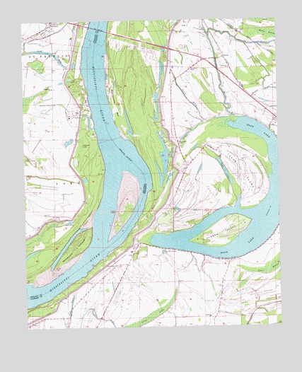
Moon Lake, MS USGS Topographic Map
Click on map above to begin viewing in our Map Viewer.

This topographic map contains these locations and features:
Feature Name Type Latitude Longitude GNIS ID View Map
Alcorn IslandIslandN34.4129°W90.5282°666181View Map
Bethlehem ChurchChurchN34.4729°W90.6109°46473View Map
Bethlehem SchoolSchoolN34.4668°W90.6120°46484View Map
Carr BrakeSwampN34.3977°W90.5051°668087View Map
Chute LakeLakeN34.4390°W90.5268°668489View Map
DanforthPopulated PlaceN34.4640°W90.5040°691800View Map
DeltaPopulated PlaceN34.4045°W90.5723°691807View Map
Delta CemeteryCemeteryN34.4048°W90.5712°689250View Map
Delta School (historical)SchoolN34.3937°W90.5907°689252View Map
Delta-Friars Point RevetmentLeveeN34.3890°W90.6043°689251View Map
Fitzhugh LandingLocaleN34.4362°W90.5857°65622View Map
Fredonia CemeteryCemeteryN34.3851°W90.5373°670172View Map
Fredonia ChurchChurchN34.3790°W90.5345°670176View Map
Gerald (historical)Populated PlaceN34.4015°W90.5743°710435View Map
Gunhouse ChuteLakeN34.4503°W90.5382°689271View Map
Helena Casting Field LandingLocaleN34.4923°W90.5940°65626View Map
Helena Crossing Elementary SchoolSchoolN34.4965°W90.6126°65628View Map
Hubbard LakeSwampN34.4495°W90.5970°50376View Map
Jerusalem ChurchChurchN34.4804°W90.5237°671862View Map
Long LakeSwampN34.3787°W90.5651°672843View Map
Long LakeLakeN34.4760°W90.6022°75771View Map
Long LakeLakeN34.4876°W90.6122°75772View Map
Montezuma BarBarN34.4654°W90.5798°673738View Map
Montezuma BendBendN34.4168°W90.5751°689306View Map
Montezuma Cut-OffChannelN34.4251°W90.5668°689307View Map
Montezuma TowheadIslandN34.4068°W90.6012°52136View Map
Montezuma Towhead DikesLeveeN34.4168°W90.5945°70120View Map
Montroy CemeteryCemeteryN34.3915°W90.5290°694024View Map
Moon LakeLakeN34.4232°W90.5202°673765View Map
Mount Nebo CemeteryCemeteryN34.4934°W90.5451°674087View Map
Mount Nebo Church (historical)ChurchN34.4904°W90.5454°689383View Map
New Morning Star ChurchChurchN34.4059°W90.5565°674781View Map
Phillips BayouLakeN34.4903°W90.5096°675682View Map
PowellPopulated PlaceN34.4851°W90.5265°692157View Map
Rowen BayouLakeN34.4684°W90.5447°676932View Map
Rush BayouGutN34.3845°W90.6029°676957View Map
Saint Luke ChurchChurchN34.4440°W90.6234°54385View Map
Saint Luke SchoolSchoolN34.4376°W90.6240°54387View Map
Saint Marks ChurchChurchN34.4501°W90.5479°677137View Map
Silver Cloud ChurchChurchN34.4004°W90.5807°677791View Map
Stokes (historical)Populated PlaceN34.4168°W90.5695°710449View Map
Stokes LandingLocaleN34.4168°W90.5715°689357View Map
Summerville Chapel (historical)ChurchN34.4365°W90.5162°689358View Map
Texas IslandIslandN34.4395°W90.5184°678655View Map
Thompson CemeteryCemeteryN34.4807°W90.5426°689368View Map
Thompson ChapelChurchN34.4804°W90.5429°678701View Map
Williamson LandingLocaleN34.4565°W90.5901°65658View Map
Willow SwampSwampN34.4944°W90.5000°679746View Map
Wilson Chapel (historical)ChurchN34.3929°W90.5743°689379View Map

Note: Coordinates in the location and feature list above are referenced to NAD83 datum.


Copyright (C) 2008-2024 Ryan Niemi / Sunset Dynamics ... All Rights Reserved