TopoQuest Logo
Do you find TopoQuest useful?
Help keep TopoQuest running and adding new maps/features by donating!
Bitcoin:  19c7KJd3qBynnjoSw5npx9KScwjBe4ifkT
Litecoin:  LXs6TkuXGGXo1vDsWCkWVdjQX94eUKd6ui
Home View Maps Find Maps Find Places Resources & Links


Friars Point, Mississippi Topographic Map

USGS Map Title: Friars Point, MS
USGS Map MRC: 34090C6
DRG (GeoTIFF) Download: o34090c6.tif


Neighboring USGS Topographic Map Quads:


  Lakeview, AR  
34090D7
 

  Friars Point NW, MS  
34090D6
 

  Moon Lake, MS  
34090D5
 

  Elaine, AR  
34090C7
 

  Friars Point, MS  
34090C6
 

  Coahoma, MS  
34090C5
 

  Rena Lara, MS  
34090B7
 

  Sherard, MS  
34090B6
 

  Clarksdale, MS  
34090B5


Map MRC Location:

N35°
W91°
N35°
W90°
H8 H7 H6 H5 H4 H3 H2 H1
G8 G7 G6 G5 G4 G3 G2 G1
F8 F7 F6 F5 F4 F3 F2 F1
E8 E7 E6 E5 E4 E3 E2 E1
D8 D7 D6 D5 D4 D3 D2 D1
C8 C7 C6 C5 C4 C3 C2 C1
B8 B7 B6 B5 B4 B3 B2 B1
A8 A7 A6 A5 A4 A3 A2 A1
N34°
W91°
N34°
W90°

Friars Point, MS USGS 1:24K Topographic Map Preview:
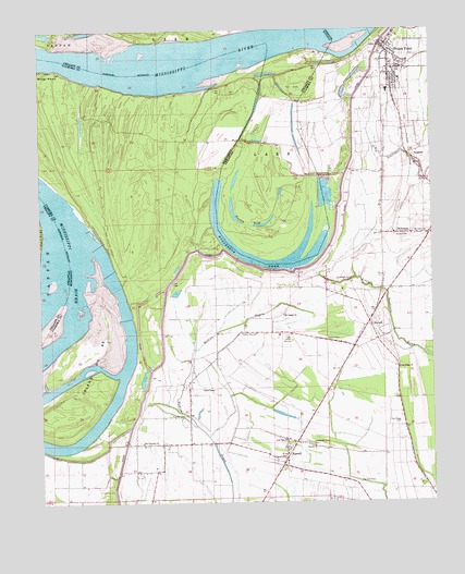
Friars Point, MS USGS Topographic Map
Click on map above to begin viewing in our Map Viewer.

This topographic map contains these locations and features:
Feature Name Type Latitude Longitude GNIS ID View Map
Bend of Island Number Sixty ThreeBendN34.2682°W90.7351°689213View Map
Carson CemeteryCemeteryN34.2937°W90.6590°668102View Map
Coahoma County Volunteer Fire Department Friars PointBuildingN34.3699°W90.6389°2665769View Map
DickersonPopulated PlaceN34.3212°W90.6365°669252View Map
Dustin PondLakeN34.3235°W90.6785°74809View Map
Elk Horn Plantation (historical)LocaleN34.3209°W90.6409°710431View Map
FarrellPopulated PlaceN34.2643°W90.6723°669919View Map
Farrell Census Designated PlaceCensusN34.2617°W90.6750°2586592View Map
Farrell ChurchChurchN34.2654°W90.6632°669920View Map
Fitzhugh LandingLocaleN34.3182°W90.7295°689264View Map
Friars PointPopulated PlaceN34.3668°W90.6376°670205View Map
Friars Point CemeteryCemeteryN34.3626°W90.6415°1805828View Map
Friars Point Elementary SchoolSchoolN34.3659°W90.6373°710433View Map
Friars Point Police DepartmentBuildingN34.3708°W90.6398°2754301View Map
Friars Point Post OfficePost OfficeN34.3705°W90.6402°2768858View Map
Horseshoe BendBendN34.3129°W90.6765°70114View Map
Horseshoe CutoffChannelN34.3726°W90.6682°65629View Map
Horseshoe LakeLakeN34.3130°W90.6770°671501View Map
Horseshoe RevetmentLeveeN34.3112°W90.6765°689277View Map
Houston LandingLocaleN34.3223°W90.7493°65630View Map
HumberPopulated PlaceN34.2807°W90.7034°689278View Map
Humber CemeteryCemeteryN34.2732°W90.7045°671577View Map
Island Number 61IslandN34.3723°W90.7293°70128View Map
Island Number Sixty three DikesLeveeN34.3112°W90.7259°689282View Map
Island Number SixtythreeIslandN34.2876°W90.7351°671733View Map
John Gilbert Pond DamDamN34.2551°W90.6434°682536View Map
Kangaroo Point DikesLeveeN34.3723°W90.6973°70116View Map
Ledbetter LandingLocaleN34.2859°W90.7209°689289View Map
Lone Oak CemeteryCemeteryN34.2670°W90.6720°689292View Map
Lone Oak ChurchChurchN34.2671°W90.6723°672782View Map
Lonesome Pine CemeteryCemeteryN34.2654°W90.6634°672791View Map
McCloud LandingLocaleN34.2684°W90.7326°689298View Map
McCloud School (historical)SchoolN34.2659°W90.7101°689299View Map
McLemore School (historical)SchoolN34.2643°W90.6718°689300View Map
McWilliams LandingLocaleN34.2995°W90.7209°689302View Map
Miller PointCapeN34.3648°W90.7446°673644View Map
Moten CemeteryCemeteryN34.3209°W90.6359°673889View Map
Mount Aaron CemeteryCemeteryN34.3215°W90.6262°689311View Map
Mount Aaron ChurchChurchN34.3212°W90.6257°673906View Map
Mount Aaron School (historical)SchoolN34.3212°W90.6270°689312View Map
Mount Pisgah ChurchChurchN34.2998°W90.6723°674207View Map
Mud Lake (historical)LakeN34.3304°W90.6426°689316View Map
Oak Ridge CemeteryCemeteryN34.2712°W90.6357°675092View Map
Oak Ridge ChurchChurchN34.2857°W90.6359°675100View Map
Oak Ridge School (historical)SchoolN34.2732°W90.6357°689326View Map
Pee Dee CemeteryCemeteryN34.2554°W90.6490°675569View Map
Pleasant Valley CemeteryCemeteryN34.2651°W90.6715°689330View Map
Pleasant Valley Church (historical)ChurchN34.2648°W90.6715°689331View Map
SessionsPopulated PlaceN34.3415°W90.6315°692220View Map
StokelyPopulated PlaceN34.2657°W90.7204°710448View Map
StovallPopulated PlaceN34.2968°W90.6448°692248View Map
Supervisor District 2CivilN34.2761°W90.6946°711824View Map
Sycamore Grove CemeteryCemeteryN34.3093°W90.6498°678510View Map
Sycamore Grove Church (historical)ChurchN34.3087°W90.6498°689366View Map
Town of Friars PointCivilN34.3680°W90.6379°2406526View Map
West End School (historical)SchoolN34.2946°W90.6718°689373View Map
Zion Traveler CemeteryCemeteryN34.2659°W90.7190°689380View Map
Zion Traveler ChurchChurchN34.2659°W90.7184°680047View Map

Note: Coordinates in the location and feature list above are referenced to NAD83 datum.


Copyright (C) 2008-2024 Ryan Niemi / Sunset Dynamics ... All Rights Reserved