TopoQuest Logo
Do you find TopoQuest useful?
Help keep TopoQuest running and adding new maps/features by donating!
Bitcoin:  19c7KJd3qBynnjoSw5npx9KScwjBe4ifkT
Litecoin:  LXs6TkuXGGXo1vDsWCkWVdjQX94eUKd6ui
Home View Maps Find Maps Find Places Resources & Links


Montrose, West Virginia Topographic Map

USGS Map Title: Montrose, WV
USGS Map MRC: 39079A7
DRG (GeoTIFF) Download: o39079a7.tif


Neighboring USGS Topographic Map Quads:


  Nestorville, WV  
39079B8
 

  Colebank, WV  
39079B7
 

  Saint George, WV  
39079B6
 

  Belington, WV  
39079A8
 

  Montrose, WV  
39079A7
 

  Parsons, WV  
39079A6
 

  Junior, WV  
38079H8
 

  Elkins, WV  
38079H7
 

  Bowden, WV  
38079H6


Map MRC Location:

N40°
W80°
N40°
W79°
H8 H7 H6 H5 H4 H3 H2 H1
G8 G7 G6 G5 G4 G3 G2 G1
F8 F7 F6 F5 F4 F3 F2 F1
E8 E7 E6 E5 E4 E3 E2 E1
D8 D7 D6 D5 D4 D3 D2 D1
C8 C7 C6 C5 C4 C3 C2 C1
B8 B7 B6 B5 B4 B3 B2 B1
A8 A7 A6 A5 A4 A3 A2 A1
N39°
W80°
N39°
W79°

Montrose, WV USGS 1:24K Topographic Map Preview:
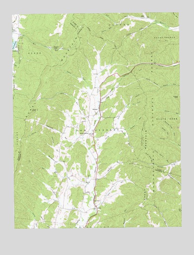
Montrose, WV USGS Topographic Map
Click on map above to begin viewing in our Map Viewer.

This topographic map contains these locations and features:
Feature Name Type Latitude Longitude GNIS ID View Map
Baldlick ForkStreamN39.0562°W79.7987°1550158View Map
Brights RunStreamN39.0507°W79.7598°1550470View Map
Bryan Hamilton SpringSpringN39.0554°W79.8606°1677702View Map
Campfield RunStreamN39.0523°W79.8231°1550624View Map
Central School (historical)SchoolN39.0554°W79.8376°1726992View Map
Cherry ForkStreamN39.0395°W79.8151°1550681View Map
Cherry Fork School (historical)SchoolN39.0582°W79.7998°1726993View Map
Choke Trap RunStreamN39.0365°W79.7703°1550707View Map
Davis LickStreamN39.0048°W79.8237°1550879View Map
East Fork Cherry ForkStreamN39.0707°W79.7881°1551011View Map
Elkins SpeedwayLocaleN39.0201°W79.8176°1557833View Map
Gainer School (historical)SchoolN39.0879°W79.8123°1727002View Map
Grasslick RunStreamN39.0390°W79.8395°1551270View Map
Harper Schoolhouse (historical)SchoolN39.1223°W79.7734°1689359View Map
Hart ChapelChurchN39.0159°W79.8148°1551379View Map
Hunting Camp RunStreamN39.0487°W79.7548°1551528View Map
Indian RunStreamN39.1218°W79.7751°1551544View Map
Israel ChurchChurchN39.0268°W79.8209°1551552View Map
Israel School (historical)SchoolN39.0265°W79.8201°1727007View Map
Ivy Hill School (historical)SchoolN39.0251°W79.8401°1727008View Map
KerensPopulated PlaceN39.0126°W79.8137°1554864View Map
Kerens Post OfficePost OfficeN39.0116°W79.8134°1727011View Map
KirtPopulated PlaceN39.1162°W79.8742°1551655View Map
Laurel Hill School (historical)SchoolN39.0887°W79.8740°1697097View Map
Laurel RunStreamN39.0751°W79.8106°1551732View Map
Laurel RunStreamN39.1190°W79.7965°1551733View Map
Lazy RunStreamN39.0098°W79.8145°1551753View Map
Leading Creek Primitive Baptist CemeteryCemeteryN39.0638°W79.8188°2586265View Map
Leading Creek Volunteer Fire DepartmentBuildingN39.0118°W79.8146°2577965View Map
Little Laurel RunStreamN39.0362°W79.7584°1551869View Map
Mill RunStreamN39.1148°W79.8745°1552128View Map
MontrosePopulated PlaceN39.0684°W79.8103°1555157View Map
Montrose Post OfficePost OfficeN39.0664°W79.8092°1727026View Map
New Interest DistrictCivilN39.0379°W79.7969°1928320View Map
Oak Grove School (historical)SchoolN39.0276°W79.7892°1727029View Map
Panther RunStreamN39.0565°W79.7942°1552427View Map
Pheasant Mountain TrailTrailN39.1062°W79.7556°1551988View Map
Pleasant MountainSummitN39.0512°W79.7781°1555369View Map
Pleasure ValleyPopulated PlaceN39.1054°W79.8442°1555376View Map
Polecat KnobSummitN39.0754°W79.7509°1555383View Map
Pond Lick RunStreamN39.0723°W79.8106°1552536View Map
Salem School (historical)SchoolN39.0368°W79.7562°1697212View Map
Saltlick RunStreamN39.0582°W79.8167°1552779View Map
Slabcamp RunStreamN39.0362°W79.7573°1552917View Map
Smith CrossingPopulated PlaceN39.0543°W79.8176°1552937View Map
South BranchStreamN39.0815°W79.7634°1552964View Map
South Haddix TrailTrailN39.0918°W79.7620°1552183View Map
Springstone RunStreamN39.0257°W79.8192°1553012View Map
Tar RunStreamN39.0304°W79.8345°1553178View Map
Teter Creek LakeReservoirN39.1071°W79.8739°1553198View Map
Teter Creek Lake Wildlife Management AreaParkN39.1073°W79.8740°1697191View Map
Thorn KnobSummitN39.0687°W79.8606°1553582View Map
Town of MontroseCivilN39.0673°W79.8143°2391312View Map
Union ChapelChurchN39.1226°W79.7756°1553313View Map
Valley ForkStreamN39.1187°W79.7701°1553334View Map
Victory School (historical)SchoolN39.0751°W79.8262°1727041View Map
Wilmoth RunStreamN39.0237°W79.8162°1553473View Map

Note: Coordinates in the location and feature list above are referenced to NAD83 datum.


Copyright (C) 2008-2024 Ryan Niemi / Sunset Dynamics ... All Rights Reserved