TopoQuest Logo
Do you find TopoQuest useful?
Help keep TopoQuest running and adding new maps/features by donating!
Bitcoin:  19c7KJd3qBynnjoSw5npx9KScwjBe4ifkT
Litecoin:  LXs6TkuXGGXo1vDsWCkWVdjQX94eUKd6ui
Home View Maps Find Maps Find Places Resources & Links


Junior, West Virginia Topographic Map

USGS Map Title: Junior, WV
USGS Map MRC: 38079H8
DRG (GeoTIFF) Download: o38079h8.tif


Neighboring USGS Topographic Map Quads:


  Audra, WV  
39080A1
 

  Belington, WV  
39079A8
 

  Montrose, WV  
39079A7
 

  Ellamore, WV  
38080H1
 

  Junior, WV  
38079H8
 

  Elkins, WV  
38079H7
 

  Cassity, WV  
38080G1
 

  Beverly West, WV  
38079G8
 

  Beverly East, WV  
38079G7


Map MRC Location:

N39°
W80°
N39°
W79°
H8 H7 H6 H5 H4 H3 H2 H1
G8 G7 G6 G5 G4 G3 G2 G1
F8 F7 F6 F5 F4 F3 F2 F1
E8 E7 E6 E5 E4 E3 E2 E1
D8 D7 D6 D5 D4 D3 D2 D1
C8 C7 C6 C5 C4 C3 C2 C1
B8 B7 B6 B5 B4 B3 B2 B1
A8 A7 A6 A5 A4 A3 A2 A1
N38°
W80°
N38°
W79°

Junior, WV USGS 1:24K Topographic Map Preview:
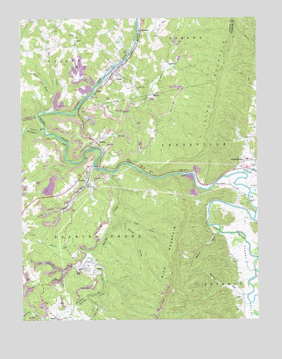
Junior, WV USGS Topographic Map
Click on map above to begin viewing in our Map Viewer.

This topographic map contains these locations and features:
Feature Name Type Latitude Longitude GNIS ID View Map
AggregatesPopulated PlaceN38.9362°W79.9187°1553702View Map
Back ForkStreamN38.9682°W79.9831°1535101View Map
Beaver CreekStreamN38.9682°W79.9631°1535446View Map
Bethel United Methodist ChurchChurchN38.9768°W79.9487°1697009View Map
Big Laurel RunStreamN38.9548°W79.9876°1535881View Map
Broad HollowValleyN38.9165°W79.9467°1536362View Map
BruxtonPopulated PlaceN38.9251°W79.8848°1726991View Map
CoaltonPopulated PlaceN38.8965°W79.9679°1560587View Map
Coalton Elementary SchoolSchoolN38.8962°W79.9685°1726995View Map
Coalton Post OfficePost OfficeN38.8959°W79.9666°1726994View Map
Coalton Volunteer Fire DepartmentBuildingN38.9038°W79.9747°2577967View Map
Coffman Methodist Episcopal ChurchChurchN38.9698°W79.9304°1697035View Map
Crystal SpringsPopulated PlaceN38.9409°W79.8773°1550854View Map
Crystal Springs Census Designated PlaceCensusN38.9424°W79.8779°2586792View Map
DartmoorPopulated PlaceN38.9954°W79.9362°1554258View Map
Dartmoor Full Gospel ChurchChurchN38.9976°W79.9354°1697047View Map
Denver Lee Shomer SpringSpringN38.9751°W79.9448°1677980View Map
Findley (historical)Populated PlaceN38.9529°W79.9984°1726998View Map
Fisher (historical)Populated PlaceN38.8804°W79.9748°1726999View Map
Flatbush ForkStreamN38.8779°W79.9976°1539065View Map
GagePopulated PlaceN38.9704°W79.9606°1554521View Map
Georgetown School (historical)SchoolN38.8846°W79.8834°1727003View Map
Goff School (historical)SchoolN38.9718°W79.9945°1697068View Map
Grassy ForkStreamN38.9926°W79.9859°1697070View Map
Grassy RunStreamN38.9384°W79.9612°1539638View Map
Gum Road BridgeBridgeN38.9259°W79.8797°2647481View Map
HardingPopulated PlaceN38.9482°W79.9592°1554644View Map
Island RunStreamN38.9720°W79.9609°1540743View Map
Jeff Scotts (historical)Populated PlaceN38.9187°W79.9512°1727009View Map
JuniorPopulated PlaceN38.9787°W79.9495°1554837View Map
Junior Church of the BrethrenChurchN38.9757°W79.9526°1697087View Map
Junior Elelmentary SchoolSchoolN38.9776°W79.9567°1697088View Map
Junior Police DepartmentBuildingN38.9801°W79.9472°2727865View Map
Junior Post OfficePost OfficeN38.9784°W79.9498°1697089View Map
Junior Volunteer Fire DepartmentBuildingN38.9815°W79.9451°2577704View Map
Kaufman Church (historical)ChurchN38.9615°W79.9676°1727010View Map
Laurel (historical)Populated PlaceN38.9607°W79.9887°1697096View Map
Laurel Hills School (historical)SchoolN38.9507°W79.8840°1727018View Map
Laurel RunStreamN38.9793°W79.9234°1697100View Map
Laurel RunStreamN38.9595°W79.9906°1541542View Map
Laurel RunStreamN38.8848°W79.9659°1551743View Map
Leading CreekStreamN38.9357°W79.8817°1551754View Map
Leiter (historical)Populated PlaceN38.9404°W79.9745°1727019View Map
Little Laurel RunStreamN38.9543°W79.9981°1542157View Map
MabiePopulated PlaceN38.8765°W79.9831°1555016View Map
Mabie Post OfficePost OfficeN38.8777°W79.9849°1727023View Map
Mathias RunStreamN38.9118°W79.8951°1542865View Map
Michael A Mikey Hart BridgeBridgeN38.9600°W79.9905°2647480View Map
Mountain View CemeteryCemeteryN38.9710°W79.9401°1543875View Map
NortonPopulated PlaceN38.9318°W79.9656°1544239View Map
Norton BridgeBridgeN38.9391°W79.9611°2647477View Map
Norton Census Designated PlaceCensusN38.9333°W79.9662°2586860View Map
Norton Post OfficePost OfficeN38.9382°W79.9617°1727028View Map
Rich Mountain School (historical)SchoolN38.9337°W79.9390°1727034View Map
Roaring CreekStreamN38.9365°W79.9509°1552686View Map
Roaring Creek JunctionPopulated PlaceN38.9409°W79.9598°1727035View Map
Skidmore (historical)Populated PlaceN38.9601°W79.9915°1697181View Map
Spring HollowValleyN38.9157°W79.9454°1547200View Map
Stonecoal School (historical)SchoolN38.9998°W79.9479°1697183View Map
TighevillePopulated PlaceN38.9798°W79.9198°1555813View Map
Town of JuniorCivilN38.9783°W79.9506°2391248View Map
Town of Junior SpringSpringN38.9798°W79.9309°1677978View Map
Town of Junior SpringSpringN38.9787°W79.9445°1677979View Map
Town of Junior SpringSpringN38.9751°W79.9437°1677981View Map
Town of WomelsdorfCivilN38.8980°W79.9637°2391491View Map
Trinity ChurchChurchN38.9907°W79.9706°1548269View Map
Tygart ValleyValleyN38.9334°W79.8898°1553306View Map
Tygart Valley Regional JailBuildingN38.9402°W79.9515°2634729View Map
Tyre School (historical)SchoolN38.9271°W79.8984°1727038View Map
WeaverPopulated PlaceN38.9693°W79.9309°1555929View Map
West JuniorPopulated PlaceN38.9801°W79.9515°1697204View Map
Whites RunStreamN38.9032°W79.9648°1549098View Map
Whitman RunStreamN38.8818°W79.8795°1549111View Map
Zebs CreekStreamN38.9618°W79.9829°1549481View Map

Note: Coordinates in the location and feature list above are referenced to NAD83 datum.


Copyright (C) 2008-2024 Ryan Niemi / Sunset Dynamics ... All Rights Reserved