TopoQuest Logo
Do you find TopoQuest useful?
Help keep TopoQuest running and adding new maps/features by donating!
Bitcoin:  19c7KJd3qBynnjoSw5npx9KScwjBe4ifkT
Litecoin:  LXs6TkuXGGXo1vDsWCkWVdjQX94eUKd6ui
Home View Maps Find Maps Find Places Resources & Links


Monroe City, Indiana Topographic Map

USGS Map Title: Monroe City, IN
USGS Map MRC: 38087E3
DRG (GeoTIFF) Download: o38087e3.tif


Neighboring USGS Topographic Map Quads:


  Fritchton, IN  
38087F4
 

  Wheatland, IN  
38087F3
 

  Washington, IN  
38087F2
 

  Iona, IN  
38087E4
 

  Monroe City, IN  
38087E3
 

  Sandy Hook, IN  
38087E2
 

  Union, IN  
38087D4
 

  Petersburg, IN  
38087D3
 

  Winslow, IN  
38087D2


Map MRC Location:

N39°
W88°
N39°
W87°
H8 H7 H6 H5 H4 H3 H2 H1
G8 G7 G6 G5 G4 G3 G2 G1
F8 F7 F6 F5 F4 F3 F2 F1
E8 E7 E6 E5 E4 E3 E2 E1
D8 D7 D6 D5 D4 D3 D2 D1
C8 C7 C6 C5 C4 C3 C2 C1
B8 B7 B6 B5 B4 B3 B2 B1
A8 A7 A6 A5 A4 A3 A2 A1
N38°
W88°
N38°
W87°

Monroe City, IN USGS 1:24K Topographic Map Preview:
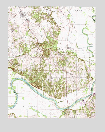
Monroe City, IN USGS Topographic Map
Click on map above to begin viewing in our Map Viewer.

This topographic map contains these locations and features:
Feature Name Type Latitude Longitude GNIS ID View Map
ArdaPopulated PlaceN38.5173°W87.2506°430241View Map
Bartons LocationPopulated PlaceN38.5292°W87.3395°446741View Map
Beech HillsRangeN38.5450°W87.3397°430734View Map
Brush CreekStreamN38.5256°W87.3250°431675View Map
Buckhorn CreekStreamN38.5248°W87.3236°431749View Map
Clear PondLakeN38.6249°W87.2719°432628View Map
Farm Service Agency Interest of IndianaParkN38.5064°W87.3034°2765290View Map
Five PointsPopulated PlaceN38.6103°W87.3481°434548View Map
Freeland CemeteryCemeteryN38.5440°W87.3134°434811View Map
Frick DitchCanalN38.5928°W87.2767°434838View Map
Hamline ChapelChurchN38.5600°W87.3611°435654View Map
Harrison Township Volunteer Fire DepartmentBuildingN38.6140°W87.3531°2626220View Map
Lick CreekStreamN38.5281°W87.2542°437867View Map
Long PondLakeN38.5866°W87.2610°438277View Map
Lucky PointCliffN38.6159°W87.3158°438393View Map
Monroe CityPopulated PlaceN38.6153°W87.3545°439342View Map
Patrick DitchCanalN38.6170°W87.2636°440927View Map
Pond Creek MillsPopulated PlaceN38.5778°W87.2864°452179View Map
Prides CreekStreamN38.5100°W87.2947°441597View Map
Sevenmile BendBendN38.5181°W87.3653°443226View Map
South Knox Elementary SchoolSchoolN38.6112°W87.3495°447480View Map
The BluffsCliffN38.5100°W87.2906°444664View Map
Town of Monroe CityCivilN38.6145°W87.3530°2396772View Map
Township of HarrisonCivilN38.5808°W87.3537°453390View Map
Walnut Grove CemeteryCemeteryN38.5781°W87.2892°2013786View Map
Walnut Grove ChurchChurchN38.5781°W87.2900°445425View Map
Walnut Hill CemeteryCemeteryN38.5006°W87.2895°445431View Map
Walnut Hill CemeteryCemeteryN38.5000°W87.2900°445433View Map
Warner LakeLakeN38.5060°W87.2938°445475View Map
Whiteriver Airfield (historical)AirportN38.5067°W87.3047°449309View Map
WillisPopulated PlaceN38.5534°W87.3572°446091View Map
Wilson Creek ChurchChurchN38.5828°W87.3339°446138View Map
Wrights Ferry (historical)LocaleN38.5431°W87.3522°448373View Map

Note: Coordinates in the location and feature list above are referenced to NAD83 datum.


Copyright (C) 2008-2024 Ryan Niemi / Sunset Dynamics ... All Rights Reserved