TopoQuest Logo
Do you find TopoQuest useful?
Help keep TopoQuest running and adding new maps/features by donating!
Bitcoin:  19c7KJd3qBynnjoSw5npx9KScwjBe4ifkT
Litecoin:  LXs6TkuXGGXo1vDsWCkWVdjQX94eUKd6ui
Home View Maps Find Maps Find Places Resources & Links


Monadnock Mountain, Vermont Topographic Map

USGS Map Title: Monadnock Mountain, VT
USGS Map MRC: 44071H5
DRG (GeoTIFF) Download: o44071h5.tif


Neighboring USGS Topographic Map Quads:


  Pittsburg, NH  
45071A4
 

  Averill, VT  
44071H6
 

  Monadnock Mountain, VT  
44071H5
 

  Lovering Mountain, NH  
44071H4
 

  Bloomfield, VT  
44071G6
 

  Tinkerville, NH  
44071G5
 

  Bunnell Mountain, NH  
44071G4


Map MRC Location:

N45°
W72°
N45°
W71°
H8 H7 H6 H5 H4 H3 H2 H1
G8 G7 G6 G5 G4 G3 G2 G1
F8 F7 F6 F5 F4 F3 F2 F1
E8 E7 E6 E5 E4 E3 E2 E1
D8 D7 D6 D5 D4 D3 D2 D1
C8 C7 C6 C5 C4 C3 C2 C1
B8 B7 B6 B5 B4 B3 B2 B1
A8 A7 A6 A5 A4 A3 A2 A1
N44°
W72°
N44°
W71°

Monadnock Mountain, VT USGS 1:24K Topographic Map Preview:
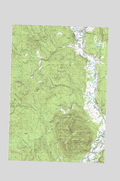
Monadnock Mountain, VT USGS Topographic Map
Click on map above to begin viewing in our Map Viewer.

This topographic map contains these locations and features:
Feature Name Type Latitude Longitude GNIS ID View Map
Alder BrookStreamN44.9259°W71.6015°1456129View Map
Alice M Ward Memorial LibraryBuildingN44.9923°W71.5423°1919290View Map
Arlin BrookStreamN44.9245°W71.5093°865258View Map
ArlinsPopulated PlaceN44.9228°W71.5112°1460369View Map
Back PondReservoirN44.9819°W71.5134°865306View Map
Back Pond DamDamN44.9817°W71.5112°1775798View Map
Bolter BrookStreamN44.9453°W71.5423°1456510View Map
Brown BrookStreamN44.9489°W71.5162°865814View Map
Bunnell Airfield (historical)AirportN44.9328°W71.5254°1919304View Map
Bunnell BrookStreamN44.9798°W71.5645°1456652View Map
Camp Number Five (historical)LocaleN44.8934°W71.5795°1460377View Map
Camp Number Four (historical)LocaleN44.8892°W71.5965°1460376View Map
Camp Number Three (historical)LocaleN44.8770°W71.6223°1460375View Map
CanaanPopulated PlaceN44.9962°W71.5384°1456760View Map
Canaan Hill CemeteryCemeteryN44.9718°W71.6048°1919308View Map
Canaan Post OfficePost OfficeN44.9991°W71.5328°1919310View Map
Canaan Village CemeteryCemeteryN44.9973°W71.5369°1919311View Map
Canann Elementary SchoolSchoolN44.9954°W71.5377°1919307View Map
Canann High SchoolSchoolN44.9954°W71.5377°1919309View Map
Capon BrookStreamN44.9378°W71.5206°1456765View Map
Clay BrookStreamN44.9692°W71.5843°1456910View Map
ColumbiaPopulated PlaceN44.8778°W71.5143°873306View Map
Corr HillSummitN44.8775°W71.5784°1457025View Map
Day BrookStreamN44.9689°W71.5231°866509View Map
Gifford FieldAirportN44.8883°W71.5073°873383View Map
Hudson BrookStreamN44.9428°W71.5381°1460380View Map
Jacobs Chopping BrookStreamN44.9748°W71.5718°1457986View Map
Kemp HillSummitN44.9625°W71.5576°1458065View Map
Keyer BrookStreamN44.9803°W71.5359°1458079View Map
Leach CreekStreamN44.9862°W71.5400°1458180View Map
Lower DamDamN44.9984°W71.5312°1774988View Map
Meacham SwampSwampN44.8978°W71.6026°1458405View Map
Mohawk RiverStreamN44.9020°W71.5020°868512View Map
Monadnock MountainSummitN44.8975°W71.5445°1458515View Map
Morrison-Schoolhouse CemeteryCemeteryN44.9274°W71.5228°1919370View Map
Oblate Fathers NovitiateChurchN44.8787°W71.5126°868882View Map
Old Canaan Hill CemeteryCemeteryN44.9795°W71.6062°1919382View Map
Schoolhouse BrookStreamN44.9706°W71.5951°1459427View Map
Simms StreamStreamN44.8806°W71.5212°869934View Map
South Canaan Church CemeteryCemeteryN44.9315°W71.5234°1919406View Map
Stewartstown Community SchoolSchoolN44.9988°W71.5228°2500280View Map
Todd HillSummitN44.9228°W71.5648°1459920View Map
Town of CanaanCivilN44.9775°W71.5782°1462064View Map
Town of LemingtonCivilN44.8907°W71.5831°1462133View Map
Van Dyke MountainSummitN44.9889°W71.5476°1460013View Map
West Branch Willard StreamStreamN44.9259°W71.6029°1460386View Map
West StewartstownPopulated PlaceN44.9953°W71.5312°870796View Map
West Stewartstown Census Designated PlaceCensusN44.9906°W71.5311°2629746View Map
West Stewartstown Post OfficePost OfficeN44.9954°W71.5330°1916382View Map
Willard StreamStreamN44.9262°W71.5131°1460371View Map
Wilson CemeteryCemeteryN44.9376°W71.5250°1919420View Map

Note: Coordinates in the location and feature list above are referenced to NAD83 datum.


Copyright (C) 2008-2024 Ryan Niemi / Sunset Dynamics ... All Rights Reserved