TopoQuest Logo
Do you find TopoQuest useful?
Help keep TopoQuest running and adding new maps/features by donating!
Bitcoin:  19c7KJd3qBynnjoSw5npx9KScwjBe4ifkT
Litecoin:  LXs6TkuXGGXo1vDsWCkWVdjQX94eUKd6ui
Home View Maps Find Maps Find Places Resources & Links


Lovering Mountain, New Hampshire Topographic Map

USGS Map Title: Lovering Mountain, NH
USGS Map MRC: 44071H4
DRG (GeoTIFF) Download: o44071h4.tif


Neighboring USGS Topographic Map Quads:


  Pittsburg, NH  
45071A4
 

  Lake Francis, NH  
45071A3
 

  Monadnock Mountain, VT  
44071H5
 

  Lovering Mountain, NH  
44071H4
 

  Diamond Pond, NH  
44071H3
 

  Tinkerville, NH  
44071G5
 

  Bunnell Mountain, NH  
44071G4
 

  Dixville Notch, NH  
44071G3


Map MRC Location:

N45°
W72°
N45°
W71°
H8 H7 H6 H5 H4 H3 H2 H1
G8 G7 G6 G5 G4 G3 G2 G1
F8 F7 F6 F5 F4 F3 F2 F1
E8 E7 E6 E5 E4 E3 E2 E1
D8 D7 D6 D5 D4 D3 D2 D1
C8 C7 C6 C5 C4 C3 C2 C1
B8 B7 B6 B5 B4 B3 B2 B1
A8 A7 A6 A5 A4 A3 A2 A1
N44°
W72°
N44°
W71°

Lovering Mountain, NH USGS 1:24K Topographic Map Preview:
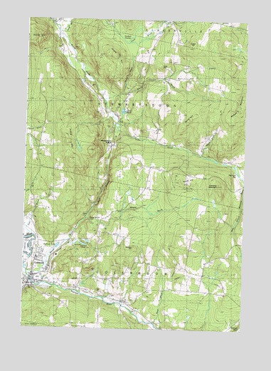
Lovering Mountain, NH USGS Topographic Map
Click on map above to begin viewing in our Map Viewer.

This topographic map contains these locations and features:
Feature Name Type Latitude Longitude GNIS ID View Map
Bear Rock BogSwampN44.9404°W71.3795°865460View Map
Bear Rock SchoolSchoolN44.9328°W71.3759°871101View Map
Beaver BrookStreamN44.9192°W71.4654°865478View Map
Beaver Brook FallsFallsN44.9192°W71.4637°865484View Map
Beaver Brook Wayside AreaLocaleN44.9200°W71.4648°1916195View Map
Brackett SchoolSchoolN44.9139°W71.4576°871102View Map
Cedar BrookStreamN44.9673°W71.4565°871107View Map
Cedar Brook School (historical)SchoolN44.9514°W71.4273°871108View Map
Clarksville Pond School (historical)SchoolN44.9992°W71.3898°871110View Map
ColebrookPopulated PlaceN44.8945°W71.4959°866283View Map
Colebrook AcademySchoolN44.8951°W71.4950°1916220View Map
Colebrook Census Designated PlaceCensusN44.8946°W71.4948°2629721View Map
Colebrook Country ClubLocaleN44.8953°W71.4909°1916221View Map
Colebrook Elementary SchoolSchoolN44.8923°W71.4993°1916222View Map
Colebrook Fire DepartmentBuildingN44.8938°W71.4950°2605116View Map
Colebrook Police DeptBuildingN44.8948°W71.4978°2752981View Map
Colebrook Post OfficePost OfficeN44.8925°W71.4943°1916223View Map
Colebrook Primary SchoolSchoolN44.8925°W71.4993°1916224View Map
Collins HillSummitN44.9856°W71.4495°866290View Map
Community Baptist SchoolSchoolN44.8953°W71.4973°1916227View Map
Dearth HillSummitN44.9909°W71.4934°866520View Map
Dyer BrookStreamN44.8970°W71.4920°866676View Map
East Colebrook Church (historical)ChurchN44.8984°W71.4059°871115View Map
Factory School (historical)SchoolN44.8875°W71.4451°871116View Map
Forbes School (historical)SchoolN44.9167°W71.4051°871118View Map
Gulch BrookStreamN44.9706°W71.4470°867274View Map
Haines BrookStreamN44.9450°W71.4029°867301View Map
Haines School (historical)SchoolN44.9553°W71.3967°871120View Map
Hurlbert SwampSwampN44.9916°W71.4424°867695View Map
Kidder HillSummitN44.9895°W71.4084°867859View Map
KiddervillePopulated PlaceN44.8764°W71.3765°871195View Map
Ladd PondLakeN44.9629°W71.4446°871051View Map
Lang HillSummitN44.9809°W71.4262°867945View Map
Lombard PondLakeN44.9091°W71.4655°868122View Map
Lovering MountainSummitN44.9339°W71.3926°868194View Map
Matthews PondLakeN44.9085°W71.4804°868310View Map
Mudget MountainSummitN44.9639°W71.3815°868659View Map
North Branch Beaver BrookStreamN44.9200°W71.4640°871052View Map
North Branch Mohawk RiverStreamN44.9192°W71.4645°868765View Map
North HillSummitN44.9614°W71.4079°868787View Map
North Hill School (historical)SchoolN44.9748°W71.4223°871131View Map
Numismatic International Book LibraryBuildingN44.8939°W71.4904°1916331View Map
Piper HillRidgeN44.9514°W71.4754°869217View Map
Piper Hill School (historical)SchoolN44.9503°W71.4920°871133View Map
Piper School (historical)SchoolN44.9200°W71.4948°871134View Map
Pond BrookStreamN44.9953°W71.4798°869290View Map
Read BrookStreamN44.8775°W71.4273°869459View Map
South HillSummitN44.9364°W71.4123°870037View Map
South Hill School (historical)SchoolN44.9400°W71.4301°871138View Map
Stevens HillSummitN44.9078°W71.4376°870169View Map
Stewartstown HollowPopulated PlaceN44.9487°W71.4526°870176View Map
Stewartstown Hollow School (historical)SchoolN44.9598°W71.4484°871140View Map
Town of ColebrookCivilN44.8990°W71.4148°871097View Map
Town of StewartstownCivilN44.9610°W71.4136°871096View Map
Upper Connecticut Valley HospitalHospitalN44.9045°W71.4808°2580632View Map
Whittemore School (historical)SchoolN44.8909°W71.4009°871145View Map

Note: Coordinates in the location and feature list above are referenced to NAD83 datum.


Copyright (C) 2008-2024 Ryan Niemi / Sunset Dynamics ... All Rights Reserved