TopoQuest Logo
Do you find TopoQuest useful?
Help keep TopoQuest running and adding new maps/features by donating!
Bitcoin:  19c7KJd3qBynnjoSw5npx9KScwjBe4ifkT
Litecoin:  LXs6TkuXGGXo1vDsWCkWVdjQX94eUKd6ui
Home View Maps Find Maps Find Places Resources & Links


Mineral Wells West, Texas Topographic Map

USGS Map Title: Mineral Wells West, TX
USGS Map MRC: 32098G2
DRG (GeoTIFF) Download: o32098g2.tif


Neighboring USGS Topographic Map Quads:


  Graford West, TX  
32098H3
 

  Graford East, TX  
32098H2
 

  Whitt, TX  
32098H1
 

  Palo Pinto, TX  
32098G3
 

  Mineral Wells West, TX  
32098G2
 

  Mineral Wells East, TX  
32098G1
 

  Lone Camp, TX  
32098F3
 

  Brazos West, TX  
32098F2
 

  Brazos East, TX  
32098F1


Map MRC Location:

N33°
W99°
N33°
W98°
H8 H7 H6 H5 H4 H3 H2 H1
G8 G7 G6 G5 G4 G3 G2 G1
F8 F7 F6 F5 F4 F3 F2 F1
E8 E7 E6 E5 E4 E3 E2 E1
D8 D7 D6 D5 D4 D3 D2 D1
C8 C7 C6 C5 C4 C3 C2 C1
B8 B7 B6 B5 B4 B3 B2 B1
A8 A7 A6 A5 A4 A3 A2 A1
N32°
W99°
N32°
W98°

Mineral Wells West, TX USGS 1:24K Topographic Map Preview:
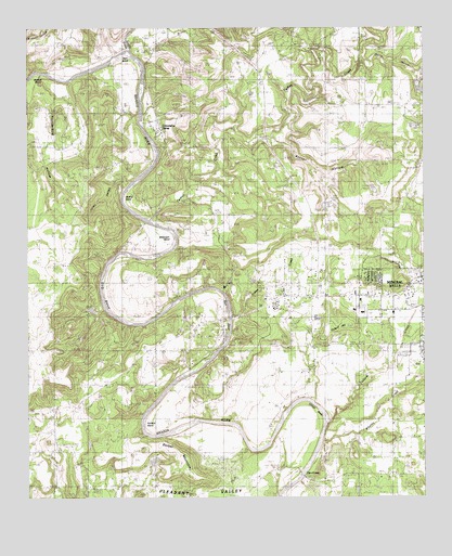
Mineral Wells West, TX USGS Topographic Map
Click on map above to begin viewing in our Map Viewer.

This topographic map contains these locations and features:
Feature Name Type Latitude Longitude GNIS ID View Map
Baker HollowValleyN32.8459°W98.1737°1329952View Map
Ballenger BendBendN32.8171°W98.2067°1329989View Map
Barber MountainSummitN32.7626°W98.2070°1330029View Map
Bath BendBendN32.7985°W98.1923°1330136View Map
Birdwell HollowValleyN32.8634°W98.2486°1330712View Map
Coronados CampPopulated PlaceN32.8487°W98.2095°1889684View Map
Critical Air 55BuildingN32.7993°W98.1458°2656184View Map
Dike LakeReservoirN32.8592°W98.1265°1864743View Map
Dike Lake DamDamN32.8601°W98.1270°1864742View Map
Dog BendBendN32.8037°W98.2214°1334442View Map
Elmhurst ParkParkN32.7887°W98.1342°2028427View Map
Hart BendBendN32.8626°W98.2192°1337413View Map
Hittson BendBendN32.7704°W98.1634°1337847View Map
Hittson CemeteryCemeteryN32.7604°W98.1714°1337849View Map
Indian CreekStreamN32.7932°W98.1867°1338403View Map
Indian Creek CemeteryCemeteryN32.8054°W98.1745°1338423View Map
Jones HollowValleyN32.8318°W98.2198°1338859View Map
Keechi CreekStreamN32.8690°W98.2184°1338975View Map
Lake PintoReservoirN32.8117°W98.1250°1344114View Map
Locke CemeteryCemeteryN32.8207°W98.1934°1340305View Map
Metcalf BendBendN32.8582°W98.2459°1341430View Map
Miller StadiumParkN32.8026°W98.1312°2027808View Map
Mineral Wells DivisionCivilN32.7826°W98.1254°1939000View Map
Mineral Wells ParkParkN32.8087°W98.1328°2029760View Map
Moffitt BendBendN32.8290°W98.2175°1341790View Map
Palo Pinto General HospitalHospitalN32.7993°W98.1449°2015739View Map
Palo Pinto General Hospital HeliportAirportN32.7987°W98.1462°1387205View Map
Pleasant ValleyFlatN32.7726°W98.1620°1889686View Map
Pollard BendBendN32.7696°W98.2114°1344323View Map
Pollard CemeteryCemeteryN32.7790°W98.1475°1344324View Map
Pollard CreekStreamN32.7701°W98.1562°1344325View Map
Pollard HillSummitN32.7943°W98.1542°1344327View Map
Thunderburg HollowValleyN32.8568°W98.2414°1348537View Map
Turkey CreekStreamN32.8240°W98.2117°1348875View Map
Whatley CreekStreamN32.7651°W98.1578°1349889View Map
Wilson LakeReservoirN32.8285°W98.1553°1864737View Map
Wilson Lake DamDamN32.8285°W98.1553°1864736View Map

Note: Coordinates in the location and feature list above are referenced to NAD83 datum.


Copyright (C) 2008-2024 Ryan Niemi / Sunset Dynamics ... All Rights Reserved