TopoQuest Logo
Do you find TopoQuest useful?
Help keep TopoQuest running and adding new maps/features by donating!
Bitcoin:  19c7KJd3qBynnjoSw5npx9KScwjBe4ifkT
Litecoin:  LXs6TkuXGGXo1vDsWCkWVdjQX94eUKd6ui
Home View Maps Find Maps Find Places Resources & Links


Brazos East, Texas Topographic Map

USGS Map Title: Brazos East, TX
USGS Map MRC: 32098F1
DRG (GeoTIFF) Download: o32098f1.tif


Neighboring USGS Topographic Map Quads:


  Mineral Wells West, TX  
32098G2
 

  Mineral Wells East, TX  
32098G1
 

  Garner, TX  
32097G8
 

  Brazos West, TX  
32098F2
 

  Brazos East, TX  
32098F1
 

  Brock, TX  
32097F8
 

  Santo, TX  
32098E2
 

  Lipan, TX  
32098E1
 

  Dennis, TX  
32097E8


Map MRC Location:

N33°
W99°
N33°
W98°
H8 H7 H6 H5 H4 H3 H2 H1
G8 G7 G6 G5 G4 G3 G2 G1
F8 F7 F6 F5 F4 F3 F2 F1
E8 E7 E6 E5 E4 E3 E2 E1
D8 D7 D6 D5 D4 D3 D2 D1
C8 C7 C6 C5 C4 C3 C2 C1
B8 B7 B6 B5 B4 B3 B2 B1
A8 A7 A6 A5 A4 A3 A2 A1
N32°
W99°
N32°
W98°

Brazos East, TX USGS 1:24K Topographic Map Preview:
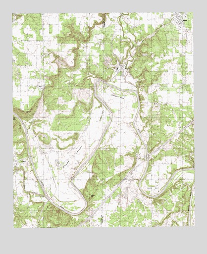
Brazos East, TX USGS Topographic Map
Click on map above to begin viewing in our Map Viewer.

This topographic map contains these locations and features:
Feature Name Type Latitude Longitude GNIS ID View Map
Arteburn PointSummitN32.6432°W98.0731°1329774View Map
BennettPopulated PlaceN32.7190°W98.0478°1330420View Map
Brannon CemeteryCemeteryN32.6465°W98.0392°1331196View Map
BrazosPopulated PlaceN32.6615°W98.1220°1331213View Map
Brazos Volunteer Fire DepartmentBuildingN32.6620°W98.1237°2552058View Map
Brock Elementary SchoolSchoolN32.6662°W98.0203°2008135View Map
Brock High SchoolSchoolN32.6674°W98.0025°2008136View Map
Dobbs ValleyBendN32.6596°W98.0870°1334425View Map
Dominicar Merlo CemeteryCemeteryN32.7196°W98.0653°1334473View Map
Fairview ChurchChurchN32.7201°W98.1217°1335641View Map
Gilbert ValleyBendN32.6910°W98.0617°1336522View Map
Goen CemeteryCemeteryN32.7132°W98.0834°1336639View Map
Grassdale CemeteryCemeteryN32.6526°W98.0478°1336845View Map
Grassy BranchStreamN32.7315°W98.0409°1336847View Map
Grindstone CreekStreamN32.6593°W98.0012°1373930View Map
Highway ChurchChurchN32.6732°W98.0234°1337765View Map
Hill CreekStreamN32.6276°W98.0028°1374075View Map
Inspiration PointSummitN32.6929°W98.1170°1889962View Map
Jones SpringsSpringN32.6418°W98.0087°1998430View Map
Littlefield BendBendN32.7007°W98.0506°1340227View Map
Meeks BendBendN32.6482°W98.0289°1341338View Map
MillsapPopulated PlaceN32.7482°W98.0092°1341692View Map
Millsap City HallBuildingN32.7456°W98.0087°2753663View Map
Millsap Post OfficePost OfficeN32.7465°W98.0080°2731962View Map
Millsap United Methodist ChurchChurchN32.7440°W98.0087°2023803View Map
Missouri Pacific DamDamN32.7418°W98.0303°1856565View Map
Missouri Pacific LakeReservoirN32.7414°W98.0426°1856566View Map
Mountain River Volunteer Fire DepartmentBuildingN32.7036°W98.0636°2551978View Map
Palo Pinto CreekStreamN32.6435°W98.1034°1375343View Map
Poe Prairie CemeteryCemeteryN32.6676°W98.0050°1344288View Map
Rock CreekStreamN32.7057°W98.0392°1345368View Map
Soda Springs Baptist ChurchChurchN32.6810°W98.0534°2023849View Map
Soda Springs ChurchChurchN32.6810°W98.0531°1347351View Map
State Highway 89 BridgeBridgeN32.6668°W98.0334°2031638View Map
Town of MillsapCivilN32.7493°W98.0117°2413002View Map
US 281 BridgeBridgeN32.6415°W98.1003°2031644View Map
Weatherford QuarryMineN32.6347°W98.0417°2710192View Map

Note: Coordinates in the location and feature list above are referenced to NAD83 datum.


Copyright (C) 2008-2024 Ryan Niemi / Sunset Dynamics ... All Rights Reserved