TopoQuest Logo
Do you find TopoQuest useful?
Help keep TopoQuest running and adding new maps/features by donating!
Bitcoin:  19c7KJd3qBynnjoSw5npx9KScwjBe4ifkT
Litecoin:  LXs6TkuXGGXo1vDsWCkWVdjQX94eUKd6ui
Home View Maps Find Maps Find Places Resources & Links


Midland, Pennsylvania Topographic Map

USGS Map Title: Midland, PA
USGS Map MRC: 40080F4
DRG (GeoTIFF) Download: o40080f4.tif


Neighboring USGS Topographic Map Quads:


  East Palestine, OH  
40080G5
 

  New Galilee, PA  
40080G4
 

  Beaver Falls, PA  
40080G3
 

  East Liverpool North, OH  
40080F5
 

  Midland, PA  
40080F4
 

  Beaver, PA  
40080F3
 

  East Liverpool South, OH  
40080E5
 

  Hookstown, PA  
40080E4
 

  Aliquippa, PA  
40080E3


Map MRC Location:

N41°
W81°
N41°
W80°
H8 H7 H6 H5 H4 H3 H2 H1
G8 G7 G6 G5 G4 G3 G2 G1
F8 F7 F6 F5 F4 F3 F2 F1
E8 E7 E6 E5 E4 E3 E2 E1
D8 D7 D6 D5 D4 D3 D2 D1
C8 C7 C6 C5 C4 C3 C2 C1
B8 B7 B6 B5 B4 B3 B2 B1
A8 A7 A6 A5 A4 A3 A2 A1
N40°
W81°
N40°
W80°

Midland, PA USGS 1:24K Topographic Map Preview:
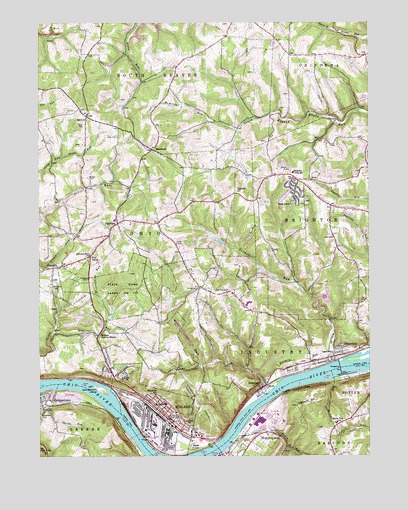
Midland, PA USGS Topographic Map
Click on map above to begin viewing in our Map Viewer.

This topographic map contains these locations and features:
Feature Name Type Latitude Longitude GNIS ID View Map
Bethlehem CemeteryCemeteryN40.6339°W80.4129°2775998View Map
Bethlehem ChurchChurchN40.6337°W80.4126°1169433View Map
Black Hawk Stage Coach Stop (historical)LocaleN40.7136°W80.4571°2556662View Map
BlackhawkPopulated PlaceN40.7131°W80.4562°1169757View Map
Blackhawk Grange Hall (historical)BuildingN40.7137°W80.4571°2556642View Map
Blackhawk Post Office (historical)Post OfficeN40.7135°W80.4567°2556602View Map
Borough of GeorgetownCivilN40.6418°W80.4993°1214876View Map
Borough of IndustryCivilN40.6595°W80.4116°1214881View Map
Borough of MidlandCivilN40.6373°W80.4565°1214883View Map
Borough of OhiovilleCivilN40.6872°W80.4783°1214887View Map
Borough of ShippingportCivilN40.6250°W80.4220°1214890View Map
Brighton Township SchoolSchoolN40.7070°W80.4034°1170252View Map
Brighton Township Volunteer Fire Department Station 63 - 3BuildingN40.7058°W80.3966°2645185View Map
Carnegie Free Library of MidlandBuildingN40.6363°W80.4510°2430209View Map
Cooks Ferry (historical)LocaleN40.6287°W80.4303°1205939View Map
DawsonPopulated PlaceN40.7017°W80.4031°1212689View Map
Esther (historical)Populated PlaceN40.6937°W80.4690°1201593View Map
FairviewPopulated PlaceN40.6923°W80.4701°1174464View Map
Fairview CemeteryCemeteryN40.6764°W80.4815°1174489View Map
Fairview ChurchChurchN40.6834°W80.4812°1174521View Map
Five PointsPopulated PlaceN40.6831°W80.4803°1174864View Map
Four Mile United Presbyterian Church CemeteryCemeteryN40.7020°W80.4200°2776005View Map
Fourmile ChurchChurchN40.7020°W80.4242°1175057View Map
Fourth Saint SchoolSchoolN40.6428°W80.4559°1175070View Map
GeorgetownPopulated PlaceN40.6415°W80.4978°1175541View Map
Georgetown CemeteryCemeteryN40.6367°W80.4995°1175544View Map
Georgetown IslandIslandN40.6445°W80.4770°1175545View Map
Georgetown Post OfficePost OfficeN40.6417°W80.4996°2777398View Map
Glass CemeteryCemeteryN40.7167°W80.4695°1175674View Map
Haden RunStreamN40.6312°W80.4251°1176355View Map
Hawthorne Valley Golf CourseLocaleN40.6717°W80.4976°1205580View Map
IndustryPopulated PlaceN40.6445°W80.4162°1177806View Map
Industry Borough Volunteer Fire Department Station 97BuildingN40.6527°W80.3955°2645333View Map
Industry Post OfficePost OfficeN40.6528°W80.3947°2777474View Map
Lincoln High SchoolSchoolN40.6356°W80.4498°1179374View Map
Lincoln Park Performing Arts Charter SchoolSchoolN40.6381°W80.4550°2432079View Map
Logan SchoolSchoolN40.6548°W80.3887°1179821View Map
McElroy RunStreamN40.7187°W80.4240°1180707View Map
McLaughlin RunStreamN40.6620°W80.4753°1200101View Map
MidlandPopulated PlaceN40.6326°W80.4465°1181076View Map
Midland Borough Police DepartmentBuildingN40.6350°W80.4507°2780474View Map
Midland CenterBuildingN40.6386°W80.4552°2430525View Map
Midland Fairview MissionChurchN40.6603°W80.4767°1181078View Map
Midland Post OfficePost OfficeN40.6365°W80.4520°2777410View Map
Midland Volunteer Fire Department Station 95BuildingN40.6351°W80.4510°2644995View Map
Montgomery Island (historical)IslandN40.6526°W80.3815°1201591View Map
Montgomery Locks and DamDamN40.6501°W80.3848°1194956View Map
Neel LandingLocaleN40.6334°W80.4998°1217407View Map
Neels SchoolSchoolN40.6403°W80.4520°1182211View Map
Oak Grove CemeteryCemeteryN40.6719°W80.4272°2776021View Map
Oak Grove ChurchChurchN40.6723°W80.4284°1182744View Map
Ohio View Public Golf CourseLocaleN40.6584°W80.3890°1205783View Map
OhioviewPopulated PlaceN40.6540°W80.3878°1182882View Map
OhiovillePopulated PlaceN40.6792°W80.4948°1182883View Map
Ohioville Borough Police DepartmentBuildingN40.6935°W80.4662°2780499View Map
Ohioville Borough Volunteer Fire Department Headquarters Station 39BuildingN40.6808°W80.4908°2645680View Map
Ohioville Borough Volunteer Fire Department Station 39 - 2BuildingN40.6946°W80.4673°2645388View Map
Ohioville SchoolSchoolN40.6737°W80.4945°1182884View Map
Old Todds CemeteryCemeteryN40.6713°W80.4278°2776013View Map
Peggs RunStreamN40.6262°W80.4317°1183445View Map
Pennsylvania Cyber Charter SchoolSchoolN40.6357°W80.4514°2431501View Map
Potter Township SchoolSchoolN40.6348°W80.3873°1184343View Map
Rolling Acres Golf CourseLocaleN40.7426°W80.4076°1205581View Map
Sainovich AirportAirportN40.6945°W80.4429°1194069View Map
Saint Paul CemeteryCemeteryN40.6734°W80.4392°1186545View Map
Salem / Highland / New Salem Presbyterian Church CemeteryCemeteryN40.7203°W80.4817°1186809View Map
Salem ChurchChurchN40.7220°W80.4815°1186842View Map
ShippingportPopulated PlaceN40.6320°W80.4140°1187556View Map
Shippingport Nuclear Powerplant (historical)LocaleN40.6356°W80.4167°1206828View Map
Shippingport Police DepartmentBuildingN40.6293°W80.4179°2780508View Map
Shippingport Post OfficePost OfficeN40.6300°W80.4181°2777431View Map
Shippingport Volunteer Fire Company Station 96BuildingN40.6292°W80.4181°2645662View Map
Sixmile RunStreamN40.6456°W80.4095°1187738View Map
Smiths RunStreamN40.6442°W80.4940°1187905View Map
Squirrel RunStreamN40.6476°W80.3881°1188374View Map
State Game Lands Number 173ParkN40.6723°W80.4684°1205937View Map
Tusca PlazaLocaleN40.7056°W80.4048°1214527View Map
Western Pennsylvania Cyber Charter SchoolSchoolN40.6357°W80.4514°2431621View Map
Wolf RunStreamN40.6434°W80.4131°1191671View Map

Note: Coordinates in the location and feature list above are referenced to NAD83 datum.


Copyright (C) 2008-2024 Ryan Niemi / Sunset Dynamics ... All Rights Reserved