TopoQuest Logo
Do you find TopoQuest useful?
Help keep TopoQuest running and adding new maps/features by donating!
Bitcoin:  19c7KJd3qBynnjoSw5npx9KScwjBe4ifkT
Litecoin:  LXs6TkuXGGXo1vDsWCkWVdjQX94eUKd6ui
Home View Maps Find Maps Find Places Resources & Links


Middletown, California Topographic Map

USGS Map Title: Middletown, CA
USGS Map MRC: 38122G5
DRG (GeoTIFF) Download: o38122g5.tif


Neighboring USGS Topographic Map Quads:


  Clearlake Highlands, CA  
38122H6
 

  Lower Lake, CA  
38122H5
 

  Wilson Valley, CA  
38122H4
 

  Whispering Pines, CA  
38122G6
 

  Middletown, CA  
38122G5
 

  Jericho Valley, CA  
38122G4
 

  Mount Saint Helena, CA  
38122F6
 

  Detert Reservoir, CA  
38122F5
 

  Aetna Springs, CA  
38122F4


Map MRC Location:

N39°
W123°
N39°
W122°
H8 H7 H6 H5 H4 H3 H2 H1
G8 G7 G6 G5 G4 G3 G2 G1
F8 F7 F6 F5 F4 F3 F2 F1
E8 E7 E6 E5 E4 E3 E2 E1
D8 D7 D6 D5 D4 D3 D2 D1
C8 C7 C6 C5 C4 C3 C2 C1
B8 B7 B6 B5 B4 B3 B2 B1
A8 A7 A6 A5 A4 A3 A2 A1
N38°
W123°
N38°
W122°

Middletown, CA USGS 1:24K Topographic Map Preview:
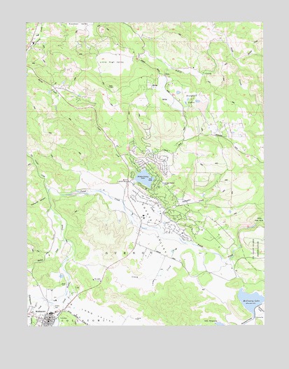
Middletown, CA USGS Topographic Map
Click on map above to begin viewing in our Map Viewer.

This topographic map contains these locations and features:
Feature Name Type Latitude Longitude GNIS ID View Map
Asbill CreekStreamN38.8655°W122.5197°254578View Map
Big Canyon CreekStreamN38.8060°W122.6144°219152View Map
Channing Rudd CellarsLocaleN38.7507°W122.5944°1766186View Map
Cockerell CanyonValleyN38.8024°W122.6139°221289View Map
CollayomiCivilN38.7507°W122.5994°221376View Map
Coyote CreekStreamN38.7841°W122.5422°221730View Map
Coyote Creek 397 DamDamN38.8099°W122.5594°1663860View Map
Coyote ValleyValleyN38.7736°W122.5450°221774View Map
Coyote Valley Elementary SchoolSchoolN38.7953°W122.5592°2516099View Map
Crazy CreekStreamN38.7760°W122.5230°221811View Map
Department of Forestry and Fire Protection South Lake County Fire Protection District Station 63BuildingN38.7967°W122.5541°2622147View Map
Department of Forestry and Fire Protection South Lake County Fire StationBuildingN38.7537°W122.6225°2622189View Map
Dry CreekStreamN38.7602°W122.6153°222625View Map
Gallagher CreekStreamN38.7952°W122.5561°224012View Map
GuenocCivilN38.7771°W122.5744°233969View Map
Guenoc (historical)Populated PlaceN38.7891°W122.5658°1766193View Map
Harbin CreekStreamN38.7860°W122.6064°224913View Map
Hidden Valley LakeReservoirN38.8107°W122.5641°1657219View Map
Hidden Valley LakePopulated PlaceN38.8080°W122.5583°1766196View Map
Hidden Valley Lake Census Designated PlaceCensusN38.8004°W122.5505°2408382View Map
Hidden Valley Lake Golf CourseLocaleN38.8030°W122.5633°1766197View Map
Lake BurgundyLakeN38.7504°W122.5248°1657218View Map
Lake County Sheriff's Department SubstationBuildingN38.7566°W122.6149°2751016View Map
Little High ValleyValleyN38.8606°W122.5692°227272View Map
Loconoma Valley Continuation High SchoolSchoolN38.7553°W122.6133°2516045View Map
Long ValleyValleyN38.7605°W122.6030°227614View Map
Lower Lake-Middletown DivisionCensusN38.8493°W122.5575°1935183View Map
McCreary 392-002 DamDamN38.7571°W122.5061°1663853View Map
McCreary LakeReservoirN38.7601°W122.5085°253232View Map
MiddletownPopulated PlaceN38.7524°W122.6150°228626View Map
Middletown Branch Lake County LibraryBuildingN38.7502°W122.6164°1766198View Map
Middletown Census Designated PlaceCensusN38.7519°W122.6221°2408828View Map
Middletown Community Day SchoolSchoolN38.7557°W122.6137°2516061View Map
Middletown DivisionCivilN38.7558°W122.5816°2583199View Map
Middletown Elem Community Day SchoolSchoolN38.7502°W122.6141°2516100View Map
Middletown High SchoolSchoolN38.7552°W122.6143°2516071View Map
Middletown Middle SchoolSchoolN38.7556°W122.6136°1766199View Map
Middletown Post OfficePost OfficeN38.7518°W122.6158°1766200View Map
Minnie Cannon Elementary SchoolSchoolN38.7568°W122.6162°1766201View Map
Palmer CreekStreamN38.8588°W122.5141°230267View Map
Saint Helena CreekStreamN38.7666°W122.6047°232162View Map
Stienhart LakesLakeN38.8461°W122.5460°235478View Map

Note: Coordinates in the location and feature list above are referenced to NAD83 datum.


Copyright (C) 2008-2024 Ryan Niemi / Sunset Dynamics ... All Rights Reserved