TopoQuest Logo
Do you find TopoQuest useful?
Help keep TopoQuest running and adding new maps/features by donating!
Bitcoin:  19c7KJd3qBynnjoSw5npx9KScwjBe4ifkT
Litecoin:  LXs6TkuXGGXo1vDsWCkWVdjQX94eUKd6ui
Home View Maps Find Maps Find Places Resources & Links


Mechanicsburg, Virginia Topographic Map

USGS Map Title: Mechanicsburg, VA
USGS Map MRC: 37080B8
DRG (GeoTIFF) Download: o37080b8.tif


Neighboring USGS Topographic Map Quads:


  Princeton, WV  
37081C1
 

  Oakvale, WV  
37080C8
 

  Narrows, VA  
37080C7
 

  Rocky Gap, VA  
37081B1
 

  Mechanicsburg, VA  
37080B8
 

  White Gate, VA  
37080B7
 

  Bland, VA  
37081A1
 

  Long Spur, VA  
37080A8
 

  Pulaski, VA  
37080A7


Map MRC Location:

N38°
W81°
N38°
W80°
H8 H7 H6 H5 H4 H3 H2 H1
G8 G7 G6 G5 G4 G3 G2 G1
F8 F7 F6 F5 F4 F3 F2 F1
E8 E7 E6 E5 E4 E3 E2 E1
D8 D7 D6 D5 D4 D3 D2 D1
C8 C7 C6 C5 C4 C3 C2 C1
B8 B7 B6 B5 B4 B3 B2 B1
A8 A7 A6 A5 A4 A3 A2 A1
N37°
W81°
N37°
W80°

Mechanicsburg, VA USGS 1:24K Topographic Map Preview:
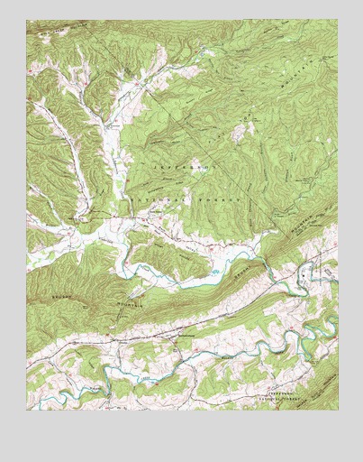
Mechanicsburg, VA USGS Topographic Map
Click on map above to begin viewing in our Map Viewer.

This topographic map contains these locations and features:
Feature Name Type Latitude Longitude GNIS ID View Map
Back ValleyValleyN37.1732°W80.9226°1481384View Map
Bland Correctional CenterBuildingN37.1685°W80.8887°1491103View Map
Bland Correctional CenterBuildingN37.1678°W80.8885°2767073View Map
Brick Church (historical)ChurchN37.1623°W80.9006°1494616View Map
Brushy RidgeRidgeN37.2251°W80.9298°1482076View Map
Byrnes Chapel Methodist ChurchChurchN37.1437°W80.9387°1482204View Map
CrandonPopulated PlaceN37.1473°W80.9631°1495435View Map
Ding BranchStreamN37.2054°W80.9648°1483016View Map
Dismal CreekStreamN37.1735°W80.9087°1483025View Map
District 3CivilN37.1822°W80.9540°1952418View Map
Double MountainSummitN37.1843°W80.8867°1495475View Map
Dry HollowValleyN37.1338°W80.9566°1483124View Map
East Wilderness CreekStreamN37.1812°W80.9776°1483220View Map
Falls of DismalFallsN37.1885°W80.9004°1483369View Map
Flea HollowValleyN37.1430°W80.9067°1483455View Map
Gauley RidgeRidgeN37.1907°W80.9698°1483600View Map
Hazel BranchStreamN37.1851°W80.9567°1484001View Map
Hiram Thompson BranchStreamN37.1765°W80.9081°1484127View Map
Holly BrookPopulated PlaceN37.1885°W80.9506°1495704View Map
Hollybrook - Mechanicsburg Volunteer Fire DepartmentBuildingN37.1869°W80.9561°2075545View Map
Hoof and Hill TrailTrailN37.2118°W80.8998°1488688View Map
Jehu HollowValleyN37.1921°W80.9740°1484407View Map
Jenny KnobSummitN37.1579°W80.9745°1484419View Map
Lickskillet HollowValleyN37.1656°W80.9479°1484838View Map
Little Horse GapGapN37.2368°W80.8812°1484915View Map
Long HollowValleyN37.1314°W80.9784°1485058View Map
Longmeadow HollowValleyN37.2099°W80.9507°1485074View Map
MechanicsburgPopulated PlaceN37.1482°W80.9412°1495928View Map
Mechanicsburg District (historical)CivilN37.1465°W80.9715°1927398View Map
Middle RidgeRidgeN37.2471°W80.9001°1485385View Map
Mire BranchStreamN37.1829°W80.9834°1485496View Map
Nobusiness CreekStreamN37.1787°W80.9606°1485878View Map
Panther Den BranchStreamN37.2376°W80.9306°1486051View Map
Pearis Thompson BranchStreamN37.1882°W80.9001°1486114View Map
Pearis Thompson Horse TrailTrailN37.2029°W80.9037°1488683View Map
Pecker BranchStreamN37.1415°W80.9345°1486119View Map
Radford Army Ammunition Fire Department and Rescue SquadBuildingN37.2006°W80.9531°2086032View Map
Roland Chimney HollowValleyN37.2170°W80.9363°1486762View Map
Rush BranchStreamN37.1943°W80.9617°1486819View Map
Shady Grove ChurchChurchN37.1862°W80.9790°1487017View Map
Shiloh ChurchChurchN37.1796°W80.9404°1487194View Map
Shingleblock RidgeRidgeN37.1962°W80.9417°1487204View Map
Short RidgesRidgeN37.1762°W80.9415°1487224View Map
Silver Creek School (historical)SchoolN37.2298°W80.9506°1494571View Map
Skydusky HollowValleyN37.1313°W80.9665°1487292View Map
Standing Branch Horse TrailTrailN37.2104°W80.8942°1488689View Map
Standrock BranchStreamN37.1935°W80.8901°1487516View Map
Stange Mines (historical)Populated PlaceN37.2037°W80.9342°1494658View Map
Turkey RidgeRidgeN37.1412°W80.9762°1488030View Map
Walnut FlatsFlatN37.1982°W80.8865°1488175View Map
Walnut Flats CampgroundLocaleN37.1982°W80.8859°1488690View Map
Wessendonck ChurchChurchN37.2160°W80.9659°1488240View Map
White Pines Horse CampLocaleN37.1932°W80.8898°1488687View Map
Wilderness BranchStreamN37.2157°W80.9679°1488378View Map
Wolfpen BranchStreamN37.1829°W80.9792°1488465View Map

Note: Coordinates in the location and feature list above are referenced to NAD83 datum.


Copyright (C) 2008-2024 Ryan Niemi / Sunset Dynamics ... All Rights Reserved