TopoQuest Logo
Do you find TopoQuest useful?
Help keep TopoQuest running and adding new maps/features by donating!
Bitcoin:  19c7KJd3qBynnjoSw5npx9KScwjBe4ifkT
Litecoin:  LXs6TkuXGGXo1vDsWCkWVdjQX94eUKd6ui
Home View Maps Find Maps Find Places Resources & Links


Long Spur, Virginia Topographic Map

USGS Map Title: Long Spur, VA
USGS Map MRC: 37080A8
DRG (GeoTIFF) Download: o37080a8.tif


Neighboring USGS Topographic Map Quads:


  Rocky Gap, VA  
37081B1
 

  Mechanicsburg, VA  
37080B8
 

  White Gate, VA  
37080B7
 

  Bland, VA  
37081A1
 

  Long Spur, VA  
37080A8
 

  Pulaski, VA  
37080A7
 

  Wytheville, VA  
36081H1
 

  Max Meadows, VA  
36080H8
 

  Fosters Falls, VA  
36080H7


Map MRC Location:

N38°
W81°
N38°
W80°
H8 H7 H6 H5 H4 H3 H2 H1
G8 G7 G6 G5 G4 G3 G2 G1
F8 F7 F6 F5 F4 F3 F2 F1
E8 E7 E6 E5 E4 E3 E2 E1
D8 D7 D6 D5 D4 D3 D2 D1
C8 C7 C6 C5 C4 C3 C2 C1
B8 B7 B6 B5 B4 B3 B2 B1
A8 A7 A6 A5 A4 A3 A2 A1
N37°
W81°
N37°
W80°

Long Spur, VA USGS 1:24K Topographic Map Preview:
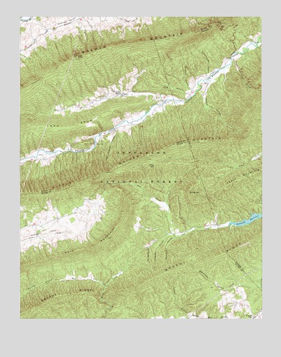
Long Spur, VA USGS Topographic Map
Click on map above to begin viewing in our Map Viewer.

This topographic map contains these locations and features:
Feature Name Type Latitude Longitude GNIS ID View Map
Bearwallow HollowValleyN37.0120°W80.8917°1481555View Map
Big HollowValleyN37.0820°W80.9360°1494609View Map
Big Spring BranchStreamN37.0940°W80.9417°1494610View Map
Brickkiln HollowValleyN37.0337°W80.9203°1481986View Map
Bridge HollowValleyN37.0812°W80.9473°1494617View Map
Bromley HollowValleyN37.0956°W80.9125°1482025View Map
Brushy RidgeRidgeN37.0143°W80.9367°1482081View Map
Church BranchStreamN37.0929°W80.9481°1494620View Map
Cove MountainSummitN37.0429°W80.9462°1482741View Map
Crow HollowValleyN37.0882°W80.9262°1494623View Map
Davis ChurchChurchN37.0721°W80.9601°1482943View Map
Davis Gate HollowValleyN37.0807°W80.9506°1494624View Map
Davis School (historical)SchoolN37.0723°W80.9606°1494625View Map
Forks of RoadLocaleN37.0137°W80.9562°1501302View Map
Gatewood ReservoirReservoirN37.0427°W80.8754°1483599View Map
Goshen CemeteryCemeteryN37.0934°W80.9515°1483717View Map
Graham HollowValleyN37.0342°W80.9238°1483739View Map
Gunton ParkLocaleN37.0010°W80.8784°1483872View Map
Gunton Park Church of God of ProphecyChurchN37.0062°W80.8840°1501311View Map
Hickory HollowValleyN37.0703°W80.9733°1484061View Map
Hidden Valley CemeteryCemeteryN37.0754°W80.9584°1484075View Map
High RockSummitN37.1085°W80.9704°1484091View Map
Hog Rock HollowValleyN37.0682°W80.9879°1494630View Map
Holston School (historical)SchoolN37.0357°W80.9231°1501315View Map
Joe Graham HollowValleyN37.0767°W80.9496°1484453View Map
Laurel HollowValleyN37.1071°W80.8897°1484716View Map
Laurel Hollow BranchStreamN37.1076°W80.8906°1501484View Map
Little Creek Volunteer Fire DepartmentBuildingN37.0724°W80.9610°2075546View Map
Little Lot HollowValleyN37.0846°W80.9331°1494642View Map
Little Spring HollowValleyN37.0297°W80.9332°1484368View Map
Long SpurLocaleN37.0929°W80.9481°1485068View Map
Long SpurRidgeN37.0798°W80.9734°1485070View Map
Long Spur Post Office (historical)Post OfficeN37.0910°W80.9281°1494643View Map
Mill Iron ChurchChurchN37.1146°W80.8787°1485445View Map
Mill Iron School (historical)SchoolN37.1148°W80.8776°1501451View Map
Panther Lick HollowValleyN37.0977°W80.9016°1486055View Map
Pine HollowValleyN37.0933°W80.9137°1486213View Map
Piney MountainSummitN37.0635°W80.9301°1486251View Map
Raven HollowValleyN37.0775°W80.9569°1494653View Map
Round MountainSummitN37.0521°W80.9126°1496174View Map
Schoolhouse HollowValleyN37.1014°W80.9029°1486962View Map
Spur BranchStreamN37.0907°W80.9220°1487493View Map
Spur Branch SchoolSchoolN37.0921°W80.9479°1487494View Map
Sulphur Spring HollowValleyN37.0796°W80.9542°1494663View Map
Wash Place HollowValleyN37.0749°W80.9617°1494670View Map
West Fork Miller CreekStreamN37.0132°W80.9559°1488255View Map

Note: Coordinates in the location and feature list above are referenced to NAD83 datum.


Copyright (C) 2008-2024 Ryan Niemi / Sunset Dynamics ... All Rights Reserved