TopoQuest Logo
Do you find TopoQuest useful?
Help keep TopoQuest running and adding new maps/features by donating!
Bitcoin:  19c7KJd3qBynnjoSw5npx9KScwjBe4ifkT
Litecoin:  LXs6TkuXGGXo1vDsWCkWVdjQX94eUKd6ui
Home View Maps Find Maps Find Places Resources & Links


Marston, North Carolina Topographic Map

USGS Map Title: Marston, NC
USGS Map MRC: 34079H5
DRG (GeoTIFF) Download: o34079h5.tif


Neighboring USGS Topographic Map Quads:


  Millstone Lake, NC  
35079A6
 

  Hoffman, NC  
35079A5
 

  Pinebluff, NC  
35079A4
 

  Hamlet, NC  
34079H6
 

  Marston, NC  
34079H5
 

  Silver Hill, NC  
34079H4
 

  Ghio, NC  
34079G6
 

  Gibson, NC  
34079G5
 

  Laurinburg, NC  
34079G4


Map MRC Location:

N35°
W80°
N35°
W79°
H8 H7 H6 H5 H4 H3 H2 H1
G8 G7 G6 G5 G4 G3 G2 G1
F8 F7 F6 F5 F4 F3 F2 F1
E8 E7 E6 E5 E4 E3 E2 E1
D8 D7 D6 D5 D4 D3 D2 D1
C8 C7 C6 C5 C4 C3 C2 C1
B8 B7 B6 B5 B4 B3 B2 B1
A8 A7 A6 A5 A4 A3 A2 A1
N34°
W80°
N34°
W79°

Marston, NC USGS 1:24K Topographic Map Preview:
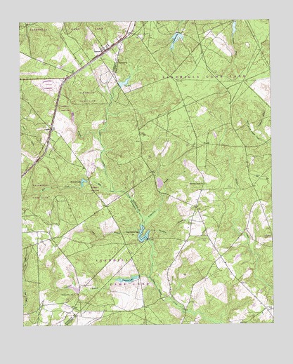
Marston, NC USGS Topographic Map
Click on map above to begin viewing in our Map Viewer.

This topographic map contains these locations and features:
Feature Name Type Latitude Longitude GNIS ID View Map
Camerons LakeReservoirN34.9927°W79.5465°998278View Map
Camp BranchStreamN34.9138°W79.5662°982494View Map
Carolina Silica MineMineN34.9458°W79.6017°2648433View Map
Catawba LakeReservoirN34.9302°W79.5531°998214View Map
Clay BranchStreamN34.9510°W79.5853°983240View Map
CognacPopulated PlaceN34.9563°W79.6098°1019718View Map
Cognac Post Office (historical)Post OfficeN34.9552°W79.6092°1731849View Map
Crawford BranchStreamN34.8943°W79.5612°983722View Map
Crawford LakeReservoirN34.8939°W79.5721°983725View Map
Crawford Lake DamDamN34.8949°W79.5667°998190View Map
Fergerson BranchStreamN34.9504°W79.5048°985051View Map
Good Hope ChurchChurchN34.9832°W79.5767°985785View Map
Gum Swamp LakeReservoirN34.9109°W79.5639°986248View Map
Gum Swamp Lake DamDamN34.9104°W79.5623°998203View Map
Hoffman Fire Department and Rescue Squad Station 2BuildingN34.9806°W79.5964°2639124View Map
Hoffman Post OfficePost OfficeN34.9989°W79.5699°2774285View Map
Kinney Cameron Lake DamDamN34.9952°W79.5459°998279View Map
Laurel Hill DamDamN34.9302°W79.5531°998215View Map
Livingston CemeteryCemeteryN34.8807°W79.5014°988822View Map
MarstonPopulated PlaceN34.9882°W79.5823°1021356View Map
Marston Poultry FarmLocaleN34.9953°W79.5947°2648435View Map
McLeods LakeReservoirN34.9343°W79.5939°989619View Map
Mill CreekStreamN34.9299°W79.5781°989943View Map
Pine LakeReservoirN34.9748°W79.5729°992260View Map
Pine Lake DamDamN34.9735°W79.5748°998255View Map
Scotland LakeReservoirN34.9971°W79.5174°998282View Map
Scotland Lake DamDamN34.9995°W79.5174°998283View Map
Smiths Grove ChurchChurchN34.8877°W79.5989°995005View Map
Timmons Grove ChurchChurchN34.9329°W79.5337°996113View Map
Township of Laurel HillCivilN34.8862°W79.5055°1027187View Map
Tuckahoe BranchStreamN34.9118°W79.5631°996290View Map
Undermine BranchStreamN34.9165°W79.5648°996412View Map
Watson CemeteryCemeteryN34.9360°W79.5078°996863View Map

Note: Coordinates in the location and feature list above are referenced to NAD83 datum.


Copyright (C) 2008-2024 Ryan Niemi / Sunset Dynamics ... All Rights Reserved