TopoQuest Logo
Do you find TopoQuest useful?
Help keep TopoQuest running and adding new maps/features by donating!
Bitcoin:  19c7KJd3qBynnjoSw5npx9KScwjBe4ifkT
Litecoin:  LXs6TkuXGGXo1vDsWCkWVdjQX94eUKd6ui
Home View Maps Find Maps Find Places Resources & Links


Gibson, North Carolina Topographic Map

USGS Map Title: Gibson, NC
USGS Map MRC: 34079G5
DRG (GeoTIFF) Download: o34079g5.tif


Neighboring USGS Topographic Map Quads:


  Hamlet, NC  
34079H6
 

  Marston, NC  
34079H5
 

  Silver Hill, NC  
34079H4
 

  Ghio, NC  
34079G6
 

  Gibson, NC  
34079G5
 

  Laurinburg, NC  
34079G4
 

  Bennettsville North, SC  
34079F6
 

  McColl, SC  
34079F5
 

  Johns, NC  
34079F4


Map MRC Location:

N35°
W80°
N35°
W79°
H8 H7 H6 H5 H4 H3 H2 H1
G8 G7 G6 G5 G4 G3 G2 G1
F8 F7 F6 F5 F4 F3 F2 F1
E8 E7 E6 E5 E4 E3 E2 E1
D8 D7 D6 D5 D4 D3 D2 D1
C8 C7 C6 C5 C4 C3 C2 C1
B8 B7 B6 B5 B4 B3 B2 B1
A8 A7 A6 A5 A4 A3 A2 A1
N34°
W80°
N34°
W79°

Gibson, NC USGS 1:24K Topographic Map Preview:
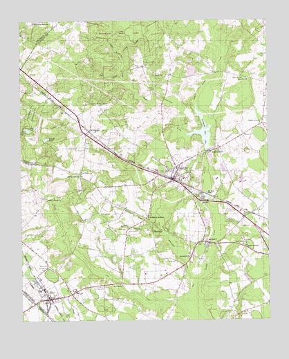
Gibson, NC USGS Topographic Map
Click on map above to begin viewing in our Map Viewer.

This topographic map contains these locations and features:
Feature Name Type Latitude Longitude GNIS ID View Map
Allen ChapelChurchN34.7824°W79.5117°980103View Map
Bass BranchStreamN34.8510°W79.5734°980599View Map
Baysville ChurchChurchN34.8510°W79.5125°980671View Map
Baysville SchoolSchoolN34.8507°W79.5125°980672View Map
Beasley BranchStreamN34.7863°W79.5520°980770View Map
Beaver Dam CemeteryCemeteryN34.7868°W79.5537°1731490View Map
Beaverdam ChurchChurchN34.7868°W79.5539°980826View Map
Blue CemeteryCemeteryN34.7527°W79.5142°981620View Map
Brown CemeteryCemeteryN34.7874°W79.5667°981997View Map
Brown CemeteryCemeteryN34.8557°W79.5645°981998View Map
Browns BranchStreamN34.7896°W79.5598°982027View Map
Cameron Grove SchoolSchoolN34.8743°W79.6167°982482View Map
Carver Middle SchoolSchoolN34.8146°W79.5520°1007031View Map
Cedar ChurchChurchN34.7665°W79.6173°982799View Map
Church of GodChurchN34.8404°W79.6073°1731491View Map
ElmorePopulated PlaceN34.7946°W79.5087°1020144View Map
Elmore CrossroadsPopulated PlaceN34.7929°W79.5117°1731492View Map
GibsonPopulated PlaceN34.7590°W79.6106°1020425View Map
Gibson CemeteryCemeteryN34.7727°W79.6117°985666View Map
Gibson CemeteryCemeteryN34.7827°W79.5350°985667View Map
Gibson CemeteryCemeteryN34.7910°W79.5184°985668View Map
Gibson Post OfficePost OfficeN34.7591°W79.6095°2774338View Map
Gibson SchoolSchoolN34.7674°W79.6153°1731493View Map
Gibson Southwest District Fire DepartmentBuildingN34.7597°W79.6088°2638582View Map
Granny BranchStreamN34.8604°W79.5739°985923View Map
Guinns Mill PondReservoirN34.8296°W79.6215°986197View Map
Gwynn CemeteryCemeteryN34.8374°W79.6137°986275View Map
Holiness ChurchChurchN34.8149°W79.5531°1731496View Map
Hursey CemeteryCemeteryN34.7979°W79.5759°987287View Map
Ida MillPopulated PlaceN34.7999°W79.5306°1020879View Map
Ida Mill PondReservoirN34.8017°W79.5311°987317View Map
Joes CreekStreamN34.7568°W79.5428°987632View Map
King CemeteryCemeteryN34.8171°W79.5378°987975View Map
Lakeside ChapelChurchN34.8204°W79.5289°1731497View Map
Laurel HillPopulated PlaceN34.8090°W79.5478°988195View Map
Laurel Hill Census Designated PlaceCensusN34.8102°W79.5460°2584324View Map
Laurel Hill Elementary SchoolSchoolN34.8090°W79.5426°1007032View Map
Laurel Hill Fire DepartmentBuildingN34.8134°W79.5474°2638925View Map
Laurel Hill Post OfficePost OfficeN34.8095°W79.5474°2774297View Map
Leviner CemeteryCemeteryN34.8057°W79.5795°988372View Map
Livingstons QuartersPopulated PlaceN34.7938°W79.5612°1021250View Map
Lower Beaverdam CreekStreamN34.7660°W79.5362°989089View Map
Malloy CemeteryCemeteryN34.8274°W79.5075°989262View Map
McNair CemeteryCemeteryN34.7890°W79.5139°989628View Map
McNeill PondReservoirN34.8256°W79.6120°989638View Map
Morgan CemeteryCemeteryN34.8027°W79.5348°990224View Map
Mudd CemeteryCemeteryN34.8007°W79.6126°990748View Map
Old HundredPopulated PlaceN34.8293°W79.5903°1021733View Map
Old Hundred CemeteryCemeteryN34.8121°W79.5942°991573View Map
Old Hundred Census Designated PlaceCensusN34.8245°W79.5921°2584328View Map
Old Hundred SchoolSchoolN34.8110°W79.5953°991574View Map
Pate CemeteryCemeteryN34.7593°W79.5776°991922View Map
Pate CemeteryCemeteryN34.7635°W79.5837°991923View Map
Pate Gardner Elementary SchoolSchoolN34.7624°W79.5887°1007663View Map
Peel ChapelChurchN34.8407°W79.5853°992006View Map
Peels Chapel CemeteryCemeteryN34.8410°W79.5850°1731499View Map
Pine Crest CemeteryCemeteryN34.7721°W79.6128°992233View Map
Rachel CemeteryCemeteryN34.8524°W79.5525°1731500View Map
Rachel ChurchChurchN34.8524°W79.5525°992975View Map
Richmond MillPopulated PlaceN34.8207°W79.5281°1022282View Map
Richmond Mill LakeReservoirN34.8285°W79.5324°993325View Map
Richmond Mill Pond DamDamN34.8204°W79.5303°998144View Map
Saint Johns CemeteryCemeteryN34.7646°W79.5739°1731502View Map
Saint Johns ChurchChurchN34.7649°W79.5739°993931View Map
Saint Marys ChurchChurchN34.8140°W79.5509°1731503View Map
Sanders CemeteryCemeteryN34.8168°W79.5498°994240View Map
Sanders CemeteryCemeteryN34.8168°W79.5539°1731504View Map
Sandy BottomsPopulated PlaceN34.7804°W79.5114°1022487View Map
Snead CemeteryCemeteryN34.7882°W79.5720°995045View Map
Snead CemeteryCemeteryN34.8343°W79.5014°995046View Map
Snead CemeteryCemeteryN34.8607°W79.5034°995048View Map
Sneads Grove ChurchChurchN34.8313°W79.5039°1731505View Map
Sneads Grove SchoolSchoolN34.8321°W79.5034°995052View Map
Speight CemeteryCemeteryN34.8260°W79.6178°995282View Map
SpringfieldPopulated PlaceN34.7829°W79.5328°1022757View Map
Springfield ChurchChurchN34.7765°W79.5398°995365View Map
Town of GibsonCivilN34.7595°W79.6069°2406564View Map
Township of WilliamsonCivilN34.7949°W79.5780°1027190View Map
Upper Beaverdam CreekStreamN34.8282°W79.5337°996546View Map
WEWO-AM (Laurinburg)TowerN34.7835°W79.5109°1018372View Map
WLNC-AM (Laurinburg)TowerN34.7846°W79.5042°1018373View Map
Woodard CemeteryCemeteryN34.7949°W79.5839°997571View Map
Wright CemeteryCemeteryN34.7910°W79.5825°1731507View Map
Wright CemeteryCemeteryN34.7749°W79.5473°997653View Map
Wright CemeteryCemeteryN34.7907°W79.5839°997654View Map
Wright CemeteryCemeteryN34.8043°W79.5948°997655View Map
Wright CemeteryCemeteryN34.8243°W79.5917°997656View Map
Wrights Branch ChurchChurchN34.8010°W79.6076°997663View Map

Note: Coordinates in the location and feature list above are referenced to NAD83 datum.


Copyright (C) 2008-2024 Ryan Niemi / Sunset Dynamics ... All Rights Reserved