TopoQuest Logo
Do you find TopoQuest useful?
Help keep TopoQuest running and adding new maps/features by donating!
Bitcoin:  19c7KJd3qBynnjoSw5npx9KScwjBe4ifkT
Litecoin:  LXs6TkuXGGXo1vDsWCkWVdjQX94eUKd6ui
Home View Maps Find Maps Find Places Resources & Links


Marana, Arizona Topographic Map

USGS Map Title: Marana, AZ
USGS Map MRC: 32111D2
DRG (GeoTIFF) Download: o32111d2.tif


Neighboring USGS Topographic Map Quads:


  Red Rock, AZ  
32111E3
 

  Desert Peak, AZ  
32111E2
 

  Tortolita Mountains, AZ  
32111E1
 

  West of Marana, AZ  
32111D3
 

  Marana, AZ  
32111D2
 

  Ruelas Canyon, AZ  
32111D1
 

  West of Avra, AZ  
32111C3
 

  Avra, AZ  
32111C2
 

  Jaynes, AZ  
32111C1


Map MRC Location:

N33°
W112°
N33°
W111°
H8 H7 H6 H5 H4 H3 H2 H1
G8 G7 G6 G5 G4 G3 G2 G1
F8 F7 F6 F5 F4 F3 F2 F1
E8 E7 E6 E5 E4 E3 E2 E1
D8 D7 D6 D5 D4 D3 D2 D1
C8 C7 C6 C5 C4 C3 C2 C1
B8 B7 B6 B5 B4 B3 B2 B1
A8 A7 A6 A5 A4 A3 A2 A1
N32°
W112°
N32°
W111°

Marana, AZ USGS 1:24K Topographic Map Preview:
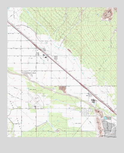
Marana, AZ USGS Topographic Map
Click on map above to begin viewing in our Map Viewer.

This topographic map contains these locations and features:
Feature Name Type Latitude Longitude GNIS ID View Map
Adonis Mobile Home SubdivisionPopulated PlaceN32.4509°W111.1947°2622811View Map
Arizona Department of Corrections Marana SchoolSchoolN32.4177°W111.2414°2544887View Map
Arizona State Prison Marana Community Correctional Treatment FacilityBuildingN32.4177°W111.2411°2751616View Map
Avra Valley Road InterchangeCrossingN32.4009°W111.1309°15271View Map
Bread of Life Assembly of GodChurchN32.4022°W111.1566°2623027View Map
Church of ChristChurchN32.4385°W111.2277°2623389View Map
Estes Elementary SchoolSchoolN32.4540°W111.2063°2544903View Map
KLLE-AM (Marana)TowerN32.4201°W111.1351°43359View Map
KOPO-FM (Marana)TowerN32.3890°W111.1457°43366View Map
MaranaLocaleN32.4584°W111.2087°7680View Map
MaranaPopulated PlaceN32.4367°W111.2254°7681View Map
Marana Career and Technical High SchoolSchoolN32.4540°W111.2086°2544849View Map
Marana Community Christian ChurchChurchN32.4537°W111.2164°2623162View Map
Marana Elementary SchoolSchoolN32.4548°W111.2087°15447View Map
Marana InterchangeCrossingN32.4620°W111.2165°15448View Map
Marana Middle SchoolSchoolN32.4522°W111.2062°15449View Map
Marana Municipal ComplexBuildingN32.4477°W111.2110°2623628View Map
Marana ParkParkN32.4481°W111.2062°15450View Map
Marana Police DepartmentBuildingN32.4478°W111.2109°15452View Map
Marana Post OfficePost OfficeN32.4488°W111.2089°44867View Map
Marana Railroad StationBuildingN32.4570°W111.2082°15451View Map
Marana Regional AirportAirportN32.4062°W111.2174°45544View Map
Northwest Fire District Station 36BuildingN32.4514°W111.2130°2622560View Map
Papago Railroad StationBuildingN32.4334°W111.1740°15511View Map
Pima County Public Library Geasa Marana BranchBuildingN32.4494°W111.2076°2623576View Map
Rattlesnake PassGapN32.3762°W111.1429°9975View Map
RillitoPopulated PlaceN32.4148°W111.1562°10281View Map
Rillito Census Designated PlaceCensusN32.4157°W111.1549°2582851View Map
Rillito Post OfficePost OfficeN32.4186°W111.1567°2622642View Map
Rillito Railroad StationBuildingN32.4123°W111.1457°15542View Map
Rillito Vista ParkParkN32.4153°W111.1548°15543View Map
Saint Christopher Catholic ChurchChurchN32.4384°W111.2225°2623245View Map
Sun and Shield Baptist ChurchChurchN32.4023°W111.1539°2623308View Map
Sun and Shield Christian AcademySchoolN32.4021°W111.1537°2543739View Map
Tangerine InterchangeCrossingN32.4245°W111.1590°15624View Map
Tangerine LandfillLocaleN32.4226°W111.1869°2622370View Map
Town of MaranaCivilN32.4355°W111.1558°2412951View Map
Tucson Electric Power Company North Loop Generating StationLocaleN32.4008°W111.1263°2622627View Map
Valley of the Sun Mobile Home ParkPopulated PlaceN32.4509°W111.2192°2622675View Map

Note: Coordinates in the location and feature list above are referenced to NAD83 datum.


Copyright (C) 2008-2024 Ryan Niemi / Sunset Dynamics ... All Rights Reserved