TopoQuest Logo
Do you find TopoQuest useful?
Help keep TopoQuest running and adding new maps/features by donating!
Bitcoin:  19c7KJd3qBynnjoSw5npx9KScwjBe4ifkT
Litecoin:  LXs6TkuXGGXo1vDsWCkWVdjQX94eUKd6ui
Home View Maps Find Maps Find Places Resources & Links


Mapleton, Oregon Topographic Map

USGS Map Title: Mapleton, OR
USGS Map MRC: 44123A7
DRG (GeoTIFF) Download: o44123a7.tif


Neighboring USGS Topographic Map Quads:


  Cummins Peak, OR  
44123B8
 

  Herman Creek, OR  
44123B7
 

  Windy Peak, OR  
44123B6
 

  Tiernan, OR  
44123A8
 

  Mapleton, OR  
44123A7
 

  Greenleaf, OR  
44123A6
 

  Goodwin Peak, OR  
43123H8
 

  Baldy Mountain, OR  
43123H7
 

  Roman Nose Mountain, OR  
43123H6


Map MRC Location:

N45°
W124°
N45°
W123°
H8 H7 H6 H5 H4 H3 H2 H1
G8 G7 G6 G5 G4 G3 G2 G1
F8 F7 F6 F5 F4 F3 F2 F1
E8 E7 E6 E5 E4 E3 E2 E1
D8 D7 D6 D5 D4 D3 D2 D1
C8 C7 C6 C5 C4 C3 C2 C1
B8 B7 B6 B5 B4 B3 B2 B1
A8 A7 A6 A5 A4 A3 A2 A1
N44°
W124°
N44°
W123°

Mapleton, OR USGS 1:24K Topographic Map Preview:
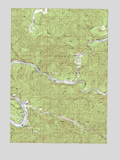
Mapleton, OR USGS Topographic Map
Click on map above to begin viewing in our Map Viewer.

This topographic map contains these locations and features:
Feature Name Type Latitude Longitude GNIS ID View Map
Archie Knowles Recreation SiteLocaleN44.0207°W123.8068°1162576View Map
Bald MountainSummitN44.0499°W123.8703°1137452View Map
Boyle CreekStreamN44.1173°W123.7532°1153612View Map
Bridge CreekStreamN44.0112°W123.7832°1138609View Map
Brush CreekStreamN44.0471°W123.7801°1138711View Map
Camp CreekStreamN44.0565°W123.8168°1153605View Map
Camp QuarryMineN44.0443°W123.8707°1638037View Map
Cleveland CreekStreamN44.0690°W123.8434°1139821View Map
Corn CreekStreamN44.0782°W123.8646°1158679View Map
Count CreekStreamN44.0590°W123.8251°1153600View Map
Davis RapidsRapidsN44.0735°W123.8574°1639234View Map
DeadwoodPopulated PlaceN44.0957°W123.7634°1140749View Map
Deadwood Boat RampLocaleN44.0952°W123.7647°2668601View Map
Deadwood CemeteryCemeteryN44.0957°W123.7531°1153614View Map
Deadwood CreekStreamN44.0946°W123.7595°1140754View Map
Deadwood Landing County ParkParkN44.0926°W123.7762°1162262View Map
Deadwood Post OfficePost OfficeN44.0949°W123.7563°1165135View Map
Dinner CreekStreamN44.0085°W123.7848°1141039View Map
East Fork Brush CreekStreamN44.0426°W123.7801°1141537View Map
Elk CreekStreamN44.1112°W123.8490°1141760View Map
Erskine Log PondReservoirN44.0687°W123.8429°1153615View Map
Green CreekStreamN44.0923°W123.7759°1143030View Map
Hadsall CreekStreamN44.0210°W123.8543°1143191View Map
Hollenbeck CreekStreamN44.0301°W123.8598°1143669View Map
Independent Order of Odd Fellows - Mapleton Lodge 3139 CemeteryCemeteryN44.0255°W123.8591°1153556View Map
Indian CreekStreamN44.0807°W123.7901°1144042View Map
Indian Creek Recreation Site (historical)LocaleN44.0943°W123.8040°1952950View Map
IndiolaPopulated PlaceN44.0807°W123.7912°1989138View Map
Jackson CreekStreamN44.0240°W123.8201°1144196View Map
Knowles CreekStreamN44.0326°W123.8562°1144693View Map
Knowles Creek Tunnel / Ralph A Peterson Tunnel 7139TunnelN44.0119°W123.7674°2668437View Map
Konnie Fishing AccessLocaleN44.0709°W123.7860°2668629View Map
La Bar CreekStreamN44.0723°W123.8598°1639230View Map
Lake CreekStreamN44.0554°W123.7965°1144760View Map
Lichtenthaler SpringSpringN44.0248°W123.8596°1153599View Map
Maple Lane Trailer Park and MarinaHarborN44.0251°W123.8555°2668341View Map
MapletonPopulated PlaceN44.0312°W123.8582°1145798View Map
Mapleton Community Association and Lane County Wastewater Treatment FacilityLocaleN44.0269°W123.8553°2660648View Map
Mapleton Elementary SchoolSchoolN44.0359°W123.8551°2463036View Map
Mapleton Fire StationBuildingN44.0365°W123.8637°2577132View Map
Mapleton Landing Boat RampLocaleN44.0155°W123.8613°2668300View Map
Mapleton Landing County ParkParkN44.0254°W123.8554°1638036View Map
Mapleton Middle and High SchoolSchoolN44.0364°W123.8534°2463037View Map
Mapleton Post OfficePost OfficeN44.0227°W123.8579°1165582View Map
Mapleton Transient FloatLocaleN44.0305°W123.8580°2668203View Map
Mapleton Water District OfficeLocaleN44.0364°W123.8627°2660797View Map
Martin CreekStreamN44.0173°W123.8740°1153616View Map
Nekoma (historical)LocaleN44.0462°W123.7565°1146765View Map
Old Man CreekStreamN44.0548°W123.8032°1147201View Map
Park CreekStreamN44.0179°W123.8632°1153596View Map
Plowman CreekStreamN44.0365°W123.8582°1153597View Map
RainrockPopulated PlaceN44.0737°W123.8526°1148180View Map
Rice CreekStreamN44.0132°W123.8526°1639236View Map
Rock CanyonValleyN44.0665°W123.8471°1639235View Map
Schindler Landing County ParkParkN44.0804°W123.7909°1162575View Map
Siuslaw (historical)LocaleN44.0587°W123.8168°1149556View Map
Siuslaw Public Library Mapleton BranchBuildingN44.0362°W123.8622°2661048View Map
Snell CreekStreamN44.0421°W123.8693°1153598View Map
SwisshomePopulated PlaceN44.0579°W123.7993°1150791View Map
Swisshome - Deadwood Rural Fire Protection District Station 1BuildingN44.0576°W123.8007°2577156View Map
Swisshome Post OfficePost OfficeN44.0576°W123.8002°1166022View Map
The HornFallsN44.0651°W123.7901°1153682View Map
Thompson CreekStreamN44.0746°W123.8607°1151089View Map
TidePopulated PlaceN44.0665°W123.8401°1151210View Map
Tide WaysideParkN44.0665°W123.8429°1153606View Map
Tide Wayside Boat RampLocaleN44.0662°W123.8398°2668262View Map
Tilden CreekStreamN44.0512°W123.7698°1151219View Map
Velvet CreekStreamN44.0979°W123.8087°1151746View Map
Wye (historical)LocaleN44.0757°W123.8726°1166312View Map

Note: Coordinates in the location and feature list above are referenced to NAD83 datum.


Copyright (C) 2008-2024 Ryan Niemi / Sunset Dynamics ... All Rights Reserved