TopoQuest Logo
Do you find TopoQuest useful?
Help keep TopoQuest running and adding new maps/features by donating!
Bitcoin:  19c7KJd3qBynnjoSw5npx9KScwjBe4ifkT
Litecoin:  LXs6TkuXGGXo1vDsWCkWVdjQX94eUKd6ui
Home View Maps Find Maps Find Places Resources & Links


Madisonville West, Kentucky Topographic Map

USGS Map Title: Madisonville West, KY
USGS Map MRC: 37087C5
DRG (GeoTIFF) Download: o37087c5.tif


Neighboring USGS Topographic Map Quads:


  Nebo, KY  
37087D6
 

  Slaughters, KY  
37087D5
 

  Hanson, KY  
37087D4
 

  Coiltown, KY  
37087C6
 

  Madisonville West, KY  
37087C5
 

  Madisonville East, KY  
37087C4
 

  Dawson Springs, KY  
37087B6
 

  Saint Charles, KY  
37087B5
 

  Nortonville, KY  
37087B4


Map MRC Location:

N38°
W88°
N38°
W87°
H8 H7 H6 H5 H4 H3 H2 H1
G8 G7 G6 G5 G4 G3 G2 G1
F8 F7 F6 F5 F4 F3 F2 F1
E8 E7 E6 E5 E4 E3 E2 E1
D8 D7 D6 D5 D4 D3 D2 D1
C8 C7 C6 C5 C4 C3 C2 C1
B8 B7 B6 B5 B4 B3 B2 B1
A8 A7 A6 A5 A4 A3 A2 A1
N37°
W88°
N37°
W87°

Madisonville West, KY USGS 1:24K Topographic Map Preview:
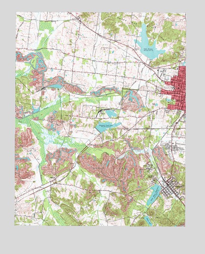
Madisonville West, KY USGS Topographic Map
Click on map above to begin viewing in our Map Viewer.

This topographic map contains these locations and features:
Feature Name Type Latitude Longitude GNIS ID View Map
Army of Six Historical MarkerParkN37.3310°W87.5076°2744440View Map
Barnsley CemeteryCemeteryN37.2584°W87.5025°486421View Map
BrentwoodPopulated PlaceN37.2967°W87.5133°487860View Map
Browns LakeReservoirN37.2531°W87.5268°488038View Map
Calvary Oakwood CemeteryCemeteryN37.2679°W87.5160°488641View Map
Carters ChapelChurchN37.3403°W87.5164°489019View Map
City of EarlingtonCivilN37.2754°W87.5065°2403529View Map
City of MadisonvilleCivilN37.3410°W87.5033°2404994View Map
Cumberland ChurchChurchN37.3281°W87.5022°490471View Map
Dozier HeightsPopulated PlaceN37.2964°W87.5078°491086View Map
Dozier LakeReservoirN37.3211°W87.5212°491087View Map
EarlingtonPopulated PlaceN37.2742°W87.5119°491420View Map
Earlington Fire DepartmentBuildingN37.2739°W87.5130°2636641View Map
Earlington Historical MarkerParkN37.2739°W87.5122°2744439View Map
Earlington Police DepartmentBuildingN37.2740°W87.5130°2767488View Map
Fuquay CemeteryCemeteryN37.3595°W87.5222°492622View Map
Greasy CreekStreamN37.3120°W87.6200°493233View Map
HeclaPopulated PlaceN37.2850°W87.5269°493995View Map
Hopkins CountyCivilN37.3088°W87.5408°516900View Map
Kington Lake (historical)LakeN37.3367°W87.5125°495772View Map
Lake PeeweeReservoirN37.3552°W87.5277°500353View Map
Loch Mary ReservoirReservoirN37.2688°W87.5228°496923View Map
Madisonville Fire Department Station 3BuildingN37.3429°W87.5140°2636697View Map
ManitouPopulated PlaceN37.3712°W87.5797°497491View Map
Mitchell HillPopulated PlaceN37.3531°W87.5375°498449View Map
Oak Grove ChurchChurchN37.3345°W87.5033°499685View Map
Odd Fellows CemeteryCemeteryN37.3314°W87.5148°497442View Map
OriolePopulated PlaceN37.2978°W87.5703°508756View Map
Oriole MineMineN37.3309°W87.6039°499996View Map
Pee VeePopulated PlaceN37.3070°W87.5406°508792View Map
Pleasant Grove ChurchChurchN37.2837°W87.5281°500820View Map
Pleasant Grove ChurchChurchN37.3448°W87.5525°500822View Map
Pleasant View (historical)Populated PlaceN37.3132°W87.5629°2743541View Map
Pleasant View ChurchChurchN37.3137°W87.5833°500947View Map
Pleasant View LakeReservoirN37.3063°W87.5633°500953View Map
Pleasant View MineMineN37.3164°W87.5611°500955View Map
Pogue CreekStreamN37.3261°W87.5598°500988View Map
RichlandPopulated PlaceN37.2773°W87.5947°501811View Map
Richland CemeteryCemeteryN37.2698°W87.6017°501812View Map
Richland ChurchChurchN37.2725°W87.6058°501815View Map
Richland CreekStreamN37.2981°W87.6036°501821View Map
Richland Fire DepartmentBuildingN37.2781°W87.5950°2636444View Map
Seminary SchoolSchoolN37.3234°W87.5019°503166View Map
Spring LakeReservoirN37.3239°W87.5129°504145View Map
Steubens Lick Historical MarkerParkN37.3667°W87.5735°2744442View Map
Sugar CreekStreamN37.2970°W87.5814°504656View Map
Tapp CemeteryCemeteryN37.3600°W87.5747°504949View Map
Twin Lakes (historical)ReservoirN37.3450°W87.5011°505716View Map
VictoriaPopulated PlaceN37.3070°W87.5078°509287View Map
WescoPopulated PlaceN37.2925°W87.5117°506387View Map
West Side HeightsPopulated PlaceN37.2773°W87.5231°506479View Map
Wicks CemeteryCemeteryN37.3559°W87.5833°506710View Map
Wicks WellLocaleN37.3581°W87.5519°506711View Map
WLCN-TV (Madisonville)TowerN37.3198°W87.5161°517750View Map
WTTL-AM (Madisonville)TowerN37.3367°W87.5447°517623View Map
Zion ChurchChurchN37.3345°W87.5033°507280View Map

Note: Coordinates in the location and feature list above are referenced to NAD83 datum.


Copyright (C) 2008-2024 Ryan Niemi / Sunset Dynamics ... All Rights Reserved