TopoQuest Logo
Do you find TopoQuest useful?
Help keep TopoQuest running and adding new maps/features by donating!
Bitcoin:  19c7KJd3qBynnjoSw5npx9KScwjBe4ifkT
Litecoin:  LXs6TkuXGGXo1vDsWCkWVdjQX94eUKd6ui
Home View Maps Find Maps Find Places Resources & Links


Machodoc, Virginia Topographic Map

USGS Map Title: Machodoc, VA
USGS Map MRC: 38076A6
DRG (GeoTIFF) Download: o38076a6.tif


Neighboring USGS Topographic Map Quads:


  Stratford Hall, VA  
38076B7
 

  Saint Clements Island, MD  
38076B6
 

  Piney Point, MD  
38076B5
 

  Montross, VA  
38076A7
 

  Machodoc, VA  
38076A6
 

  Kinsale, VA  
38076A5
 

  Tappahannock, VA  
37076H7
 

  Haynesville, VA  
37076H6
 

  Lottsburg, VA  
37076H5


Map MRC Location:

N39°
W77°
N39°
W76°
H8 H7 H6 H5 H4 H3 H2 H1
G8 G7 G6 G5 G4 G3 G2 G1
F8 F7 F6 F5 F4 F3 F2 F1
E8 E7 E6 E5 E4 E3 E2 E1
D8 D7 D6 D5 D4 D3 D2 D1
C8 C7 C6 C5 C4 C3 C2 C1
B8 B7 B6 B5 B4 B3 B2 B1
A8 A7 A6 A5 A4 A3 A2 A1
N38°
W77°
N38°
W76°

Machodoc, VA USGS 1:24K Topographic Map Preview:
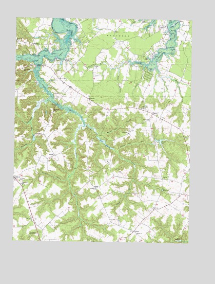
Machodoc, VA USGS Topographic Map
Click on map above to begin viewing in our Map Viewer.

This topographic map contains these locations and features:
Feature Name Type Latitude Longitude GNIS ID View Map
AcornPopulated PlaceN38.0193°W76.6491°1477060View Map
Antioch BranchStreamN38.0354°W76.7108°1462488View Map
Antioch FarmLocaleN38.0407°W76.7255°1791365View Map
Barnes CreekStreamN38.1121°W76.7180°1462804View Map
Barnes PointCapeN38.1174°W76.7108°1462806View Map
BaysidePopulated PlaceN38.1057°W76.6527°1791368View Map
Beales Mill (historical)LocaleN38.0593°W76.6916°1791369View Map
Beales Mill RunStreamN38.0657°W76.6991°1462862View Map
Beales MillpondReservoirN38.0577°W76.6893°1462863View Map
Beales WharfLocaleN38.1132°W76.7113°1462864View Map
Bible Way ChurchChurchN38.0360°W76.6422°1463293View Map
Booths BendBendN38.1174°W76.7225°1463677View Map
Boyse PointCapeN38.1062°W76.6483°1463737View Map
Bransons PointCapeN38.1193°W76.6355°1463773View Map
Browns CoveBayN38.1040°W76.7366°1463922View Map
Buena Vista BranchStreamN38.0612°W76.6897°1464024View Map
Bull NeckCapeN38.0418°W76.6777°1464067View Map
Bull NeckPopulated PlaceN38.0362°W76.6441°1791375View Map
Bull Neck RunStreamN38.0440°W76.6644°1791376View Map
Bushfield BendBendN38.1221°W76.7072°1464167View Map
Camp Hull SpringsLocaleN38.1249°W76.6586°1464333View Map
Carys PointCapeN38.1082°W76.7175°1464513View Map
Cherry Orchard PointCapeN38.1090°W76.6427°1464782View Map
Church PointCapeN38.1168°W76.6397°1464914View Map
Coles Point United Methodist ChurchChurchN38.1224°W76.6261°1465104View Map
Cople Chapel (historical)ChurchN38.0718°W76.6461°1791384View Map
Cople DistrictCivilN38.0650°W76.6501°1927160View Map
Cople District Volunteer Fire Department Engine Company 32 - Coles Point SubstationBuildingN38.0912°W76.6310°2085860View Map
Cople Elementary SchoolSchoolN38.0734°W76.6759°1465229View Map
Cupola PointCapeN38.1090°W76.6377°1465534View Map
Davis CreekStreamN38.1018°W76.7144°1465651View Map
Deep PointCapeN38.1040°W76.7347°1465709View Map
Deep Point LandingLocaleN38.1040°W76.7347°1791385View Map
Deep Point-Mount Holly Ferry (historical)CrossingN38.1043°W76.7275°1791386View Map
Doyle CoveBayN38.1037°W76.6547°1465932View Map
Drum BayBayN38.0974°W76.6530°1465960View Map
Drum Bay MarshSwampN38.0892°W76.6501°1791389View Map
Ebenezer CemeteryCemeteryN38.0048°W76.6619°1791392View Map
Ebenezer ChurchChurchN38.0046°W76.6616°1466155View Map
Edgewater ChurchChurchN38.1215°W76.6430°1466177View Map
Elba School (historical)SchoolN38.0249°W76.6330°1791393View Map
EricaPopulated PlaceN38.1185°W76.6788°1477310View Map
Green Marsh PointCapeN38.1124°W76.7150°1791407View Map
Griffiths CornerPopulated PlaceN38.0335°W76.6302°1791408View Map
HaguePopulated PlaceN38.0724°W76.6511°1495637View Map
Hague Post OfficePost OfficeN38.0730°W76.6522°2519615View Map
Hanley PointCapeN38.1037°W76.6505°1467710View Map
Harrison PointCapeN38.1004°W76.6547°1467792View Map
Hester CoveBayN38.1057°W76.6377°1467963View Map
Hickory PointCapeN38.1240°W76.7147°1467988View Map
HinnomPopulated PlaceN38.1104°W76.7369°1477416View Map
Hinnom Post Office (historical)Post OfficeN38.1112°W76.7411°1791412View Map
Howells ForkLocaleN38.0343°W76.6961°1791414View Map
Jenkins CoveBayN38.1074°W76.7280°1468670View Map
Jenkins PointCapeN38.1053°W76.7249°1468678View Map
Jerusalem ChurchChurchN38.0301°W76.6911°1468711View Map
Jones BranchStreamN38.0949°W76.6583°1468817View Map
Jules CreekStreamN38.1137°W76.7077°1468897View Map
Kings MillpondReservoirN38.0017°W76.6307°1469019View Map
Kinsale Fire Department Meeting HallBuildingN38.0711°W76.6505°2331775View Map
Kirk PointCapeN38.1060°W76.6441°1469039View Map
Knights Community HallBuildingN38.1196°W76.6836°1791418View Map
KremlinPopulated PlaceN38.0296°W76.6913°1477467View Map
Kremlin School (historical)SchoolN38.0335°W76.6966°1791419View Map
Lee CemeteryCemeteryN38.0868°W76.6458°1791421View Map
Lee CreekStreamN38.0990°W76.6486°1469263View Map
MachodocPopulated PlaceN38.0804°W76.6966°1477510View Map
Machodoc NeckCapeN38.1140°W76.6763°1469989View Map
Marshall CreekStreamN38.0674°W76.7383°1470118View Map
Marshall Creek DamDamN38.0568°W76.7330°1491024View Map
Marshall Creek PondReservoirN38.0568°W76.7330°1491025View Map
McGuires WharfLocaleN38.1026°W76.7211°1470263View Map
Midwatch PointCapeN38.0985°W76.6497°1967560View Map
Morning Star ChurchChurchN38.1118°W76.7494°1470746View Map
Mount HollyPopulated PlaceN38.0912°W76.7180°1477560View Map
Mount Holly Post OfficePost OfficeN38.0922°W76.7194°2519634View Map
Mount Olive ChurchChurchN38.0315°W76.7436°1470980View Map
Mount Pleasant BranchStreamN38.0935°W76.6455°1471027View Map
Mount Pleasant FarmLocaleN38.0951°W76.6330°1791429View Map
Mount Pleasant Plantation (historical)LocaleN38.0890°W76.6455°1791430View Map
Narrow BeachBeachN38.1229°W76.6372°1471322View Map
Narrow BeachPopulated PlaceN38.1229°W76.6372°1791431View Map
NeenahPopulated PlaceN38.0485°W76.7205°1477572View Map
Negro PointCapeN38.1143°W76.6402°1471369View Map
Newtons DamDamN38.0571°W76.6461°1491026View Map
Newtons Mill (historical)LocaleN38.0565°W76.6500°1791434View Map
Newtons Mill RunStreamN38.0512°W76.6758°1471526View Map
Newtons PondReservoirN38.0570°W76.6465°1471527View Map
NominiPopulated PlaceN38.0985°W76.7377°1496012View Map
Nomini BridgeBridgeN38.0979°W76.7327°1471559View Map
Nomini ChurchChurchN38.0985°W76.7308°1791436View Map
Nomini Ferry (historical)CrossingN38.0982°W76.7330°1791438View Map
Nomini GrovePopulated PlaceN38.0351°W76.7483°1477578View Map
Nomini HallBuildingN38.0562°W76.6991°1791437View Map
Oldfield SwampStreamN38.0726°W76.7122°1791441View Map
Oldham RunStreamN38.0354°W76.6644°1471892View Map
OldhamsPopulated PlaceN38.0026°W76.6688°1477590View Map
Oldhams Post OfficePost OfficeN38.0026°W76.6699°2519642View Map
Palmers CoveBayN38.1012°W76.7236°1472028View Map
Palmers PointCapeN38.1029°W76.7300°1472029View Map
PalmtownPopulated PlaceN38.0935°W76.6552°1791444View Map
Parham PointCapeN38.1018°W76.6494°1472056View Map
Peirce CreekStreamN38.1024°W76.7355°1472177View Map
Plumb PointCapeN38.1232°W76.6416°1472529View Map
Potomac CemeteryCemeteryN38.0610°W76.6700°1791448View Map
Potomac ChurchChurchN38.0612°W76.6683°1472706View Map
Potomac School (historical)SchoolN38.0662°W76.6630°1791449View Map
Prospect CreekStreamN38.0776°W76.7272°1791450View Map
Prospect HillSummitN38.0737°W76.7227°1496116View Map
Prospect Hill BridgeBridgeN38.0765°W76.7194°1472811View Map
Saint James ChurchChurchN38.1171°W76.6408°1473743View Map
Saint Johns ChurchChurchN38.0340°W76.7444°1473778View Map
Saint Pauls ChurchChurchN38.0690°W76.6538°1473887View Map
Salem ChurchChurchN38.0987°W76.6922°1473958View Map
Salem School (historical)SchoolN38.0979°W76.6944°1791455View Map
Shepherds PointCapeN38.1215°W76.6400°1791457View Map
Shorts Store (historical)LocaleN38.0912°W76.6316°1791459View Map
Southwest CoveBayN38.1024°W76.7163°1791463View Map
Stratter PointCapeN38.1010°W76.7366°1475239View Map
Tavern MillpondReservoirN38.0297°W76.6438°1475495View Map
Tavern RunStreamN38.0521°W76.6780°1475496View Map
Templeman RunStreamN38.0793°W76.7255°1475537View Map
Thompson BranchStreamN38.0979°W76.6755°1475649View Map
Thompson HillSummitN38.0971°W76.7452°1496312View Map
TidwellsPopulated PlaceN38.1212°W76.6447°1477812View Map
Tidwells School (historical)SchoolN38.1149°W76.6469°1791468View Map
Westmoreland Lookout TowerTowerN38.0046°W76.7327°1491291View Map
Westmoreland Volunteer Fire Department Engine Company 5BuildingN38.1186°W76.6909°2660552View Map
Westmoreland Volunteer Rescue SquadBuildingN38.0919°W76.7178°2331773View Map
Whithall Farm AirportAirportN38.1232°W76.6883°2675629View Map
Woodland AcademySchoolN38.0524°W76.7231°2465143View Map

Note: Coordinates in the location and feature list above are referenced to NAD83 datum.


Copyright (C) 2008-2024 Ryan Niemi / Sunset Dynamics ... All Rights Reserved