TopoQuest Logo
Do you find TopoQuest useful?
Help keep TopoQuest running and adding new maps/features by donating!
Bitcoin:  19c7KJd3qBynnjoSw5npx9KScwjBe4ifkT
Litecoin:  LXs6TkuXGGXo1vDsWCkWVdjQX94eUKd6ui
Home View Maps Find Maps Find Places Resources & Links


Lothair, Georgia Topographic Map

USGS Map Title: Lothair, GA
USGS Map MRC: 32082C6
DRG (GeoTIFF) Download: o32082c6.tif


Neighboring USGS Topographic Map Quads:


  Minter, GA  
32082D7
 

  Rockledge, GA  
32082D6
 

  Soperton North, GA  
32082D5
 

  Lowery, GA  
32082C7
 

  Lothair, GA  
32082C6
 

  Soperton South, GA  
32082C5
 

  Alamo, GA  
32082B7
 

  Glenwood, GA  
32082B6
 

  Mount Vernon, GA  
32082B5


Map MRC Location:

N33°
W83°
N33°
W82°
H8 H7 H6 H5 H4 H3 H2 H1
G8 G7 G6 G5 G4 G3 G2 G1
F8 F7 F6 F5 F4 F3 F2 F1
E8 E7 E6 E5 E4 E3 E2 E1
D8 D7 D6 D5 D4 D3 D2 D1
C8 C7 C6 C5 C4 C3 C2 C1
B8 B7 B6 B5 B4 B3 B2 B1
A8 A7 A6 A5 A4 A3 A2 A1
N32°
W83°
N32°
W82°

Lothair, GA USGS 1:24K Topographic Map Preview:
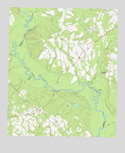
Lothair, GA USGS Topographic Map
Click on map above to begin viewing in our Map Viewer.

This topographic map contains these locations and features:
Feature Name Type Latitude Longitude GNIS ID View Map
BarnhillPopulated PlaceN32.3266°W82.6690°326167View Map
Barnhill CemeteryCemeteryN32.3263°W82.6657°342631View Map
Barwick PondSwampN32.3238°W82.6471°342632View Map
Bass BranchStreamN32.3052°W82.6679°310843View Map
Berry Hill BluffCliffN32.3521°W82.7246°354558View Map
Bethel ChurchChurchN32.2591°W82.7010°311171View Map
Beulah CemeteryCemeteryN32.2827°W82.7337°351270View Map
Beulah ChurchChurchN32.2843°W82.7285°311271View Map
Boggy BranchStreamN32.3055°W82.7099°311605View Map
Bonnie Clabber BluffCliffN32.3288°W82.7487°346495View Map
Buck CreekStreamN32.3080°W82.7326°311954View Map
Cauley's AirstripAirportN32.3297°W82.6348°2646208View Map
Clabber LandingLocaleN32.3302°W82.7468°331404View Map
Cooper CemeteryCemeteryN32.3682°W82.6985°342634View Map
Crossroads Fire DepartmentBuildingN32.2739°W82.7116°2604756View Map
Cypress CreekStreamN32.2593°W82.6393°313241View Map
Dead RiverStreamN32.3530°W82.7282°313385View Map
Faith Tabernacle ChurchChurchN32.3132°W82.6868°342635View Map
Fowlers CemeteryCemeteryN32.3749°W82.6451°342636View Map
Gov Troup GraveCemeteryN32.3357°W82.7026°314740View Map
Holiness TempleChurchN32.3738°W82.6401°315538View Map
Horseshoe PondReservoirN32.2807°W82.6705°336104View Map
Horseshoe Pond DamDamN32.2818°W82.6682°336103View Map
Joyce CemeteryCemeteryN32.3532°W82.6946°342638View Map
Lake GingerReservoirN32.3244°W82.6637°314625View Map
Little Red Bluff CreekStreamN32.3349°W82.6401°317157View Map
LothairPopulated PlaceN32.3552°W82.6554°332268View Map
Lothair ChurchChurchN32.3552°W82.6557°342639View Map
Mercer CreekStreamN32.3635°W82.7237°318035View Map
Oconee BranchStreamN32.3729°W82.7162°319894View Map
Palm LakeReservoirN32.3704°W82.7254°320161View Map
Pitts CreekStreamN32.3163°W82.7396°320775View Map
Red BluffCliffN32.2980°W82.6557°321361View Map
Red Bluff CreekStreamN32.3013°W82.6562°321367View Map
Rosemont ChurchChurchN32.3449°W82.6876°321931View Map
Saint Marks ChurchChurchN32.3432°W82.6499°322181View Map
Silver BluffCliffN32.3035°W82.6582°322982View Map
Treutlen Fire Department Station 2BuildingN32.3546°W82.6532°2604777View Map
Whitewater CreekStreamN32.3282°W82.7457°325228View Map
Williams BluffCliffN32.2960°W82.6440°325323View Map

Note: Coordinates in the location and feature list above are referenced to NAD83 datum.


Copyright (C) 2008-2024 Ryan Niemi / Sunset Dynamics ... All Rights Reserved