TopoQuest Logo
Do you find TopoQuest useful?
Help keep TopoQuest running and adding new maps/features by donating!
Bitcoin:  19c7KJd3qBynnjoSw5npx9KScwjBe4ifkT
Litecoin:  LXs6TkuXGGXo1vDsWCkWVdjQX94eUKd6ui
Home View Maps Find Maps Find Places Resources & Links


Lost Nation, Iowa Topographic Map

USGS Map Title: Lost Nation, IA
USGS Map MRC: 41090H7
DRG (GeoTIFF) Download: o41090h7.tif


Neighboring USGS Topographic Map Quads:


  Wyoming East, IA  
42090A8
 

  Baldwin, IA  
42090A7
 

  Maquoketa, IA  
42090A6
 

  Oxford Junction, IA  
41090H8
 

  Lost Nation, IA  
41090H7
 

  Elwood, IA  
41090H6
 

  Lowden, IA  
41090G8
 

  Wheatland, IA  
41090G7
 

  Grand Mound, IA  
41090G6


Map MRC Location:

N42°
W91°
N42°
W90°
H8 H7 H6 H5 H4 H3 H2 H1
G8 G7 G6 G5 G4 G3 G2 G1
F8 F7 F6 F5 F4 F3 F2 F1
E8 E7 E6 E5 E4 E3 E2 E1
D8 D7 D6 D5 D4 D3 D2 D1
C8 C7 C6 C5 C4 C3 C2 C1
B8 B7 B6 B5 B4 B3 B2 B1
A8 A7 A6 A5 A4 A3 A2 A1
N41°
W91°
N41°
W90°

Lost Nation, IA USGS 1:24K Topographic Map Preview:
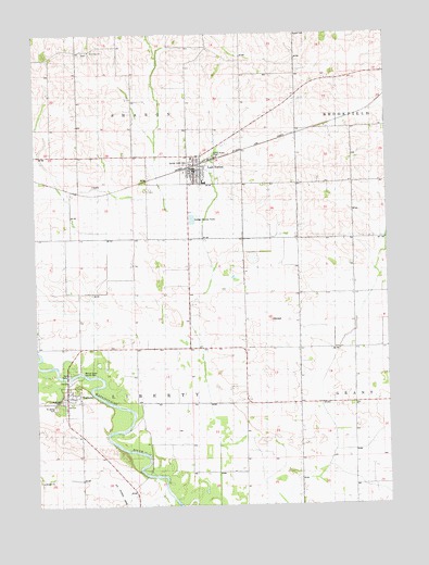
Lost Nation, IA USGS Topographic Map
Click on map above to begin viewing in our Map Viewer.

This topographic map contains these locations and features:
Feature Name Type Latitude Longitude GNIS ID View Map
Bethlehem Lutheran ChurchChurchN41.9639°W90.8176°2000754View Map
Busch CemeteryCemeteryN41.9999°W90.7822°455010View Map
City of Lost NationCivilN41.9666°W90.8167°2395767View Map
City of TorontoCivilN41.9029°W90.8628°2397038View Map
Gilroy Rustic ParkParkN41.9678°W90.8113°1825063View Map
Lost NationPopulated PlaceN41.9639°W90.8176°458634View Map
Lost Nation (historical)LocaleN41.9642°W90.8185°2000756View Map
Lost Nation CemeteryCemeteryN41.9656°W90.8190°2000851View Map
Lost Nation Post OfficePost OfficeN41.9634°W90.8185°2000752View Map
Lost Nation Public LibraryBuildingN41.9639°W90.8193°2000751View Map
Lost Nation Town HallBuildingN41.9639°W90.8193°2000750View Map
Lost Nation Volunteer Fire CompanyBuildingN41.9647°W90.8179°2000749View Map
Midland Middle SchoolSchoolN41.9606°W90.8154°2000757View Map
Rose Hill CemeteryCemeteryN41.9028°W90.8663°460796View Map
Rustic Park CemeteryCemeteryN41.9681°W90.8085°2000853View Map
Sacred Heart Catholic ChurchChurchN41.9670°W90.8190°2000755View Map
Sacred Heart CemeteryCemeteryN41.9661°W90.8196°1825064View Map
Saint James Catholic ChurchChurchN41.9050°W90.8640°2000748View Map
Saint James CemeteryCemeteryN41.9014°W90.8682°460986View Map
Smithtown CemeteryCemeteryN41.9954°W90.8554°2000854View Map
Smithtown ChurchChurchN41.9953°W90.8571°461711View Map
TorontoPopulated PlaceN41.9050°W90.8640°462280View Map
Toronto (historical)LocaleN41.9050°W90.8640°2000745View Map
Toronto Fire DepartmentBuildingN41.9050°W90.8640°2000747View Map
Toronto Fire DeptartmentBuildingN41.9049°W90.8648°2577230View Map
Toronto Post OfficePost OfficeN41.9050°W90.8640°2000746View Map
Township of LibertyCivilN41.9022°W90.8401°468215View Map
Township of SharonCivilN41.9896°W90.8401°468685View Map
Union Presbyterian ChurchChurchN41.9631°W90.8185°2000753View Map
Walnut Grove County ParkParkN41.9103°W90.8624°1825062View Map

Note: Coordinates in the location and feature list above are referenced to NAD83 datum.


Copyright (C) 2008-2024 Ryan Niemi / Sunset Dynamics ... All Rights Reserved