TopoQuest Logo
Do you find TopoQuest useful?
Help keep TopoQuest running and adding new maps/features by donating!
Bitcoin:  19c7KJd3qBynnjoSw5npx9KScwjBe4ifkT
Litecoin:  LXs6TkuXGGXo1vDsWCkWVdjQX94eUKd6ui
Home View Maps Find Maps Find Places Resources & Links


Livermore, Kentucky Topographic Map

USGS Map Title: Livermore, KY
USGS Map MRC: 37087D2
DRG (GeoTIFF) Download: o37087d2.tif


Neighboring USGS Topographic Map Quads:


  Calhoun, KY  
37087E3
 

  Glenville, KY  
37087E2
 

  Utica, KY  
37087E1
 

  Sacramento, KY  
37087D3
 

  Livermore, KY  
37087D2
 

  Equality, KY  
37087D1
 

  Millport, KY  
37087C3
 

  Central City West, KY  
37087C2
 

  Central City East, KY  
37087C1


Map MRC Location:

N38°
W88°
N38°
W87°
H8 H7 H6 H5 H4 H3 H2 H1
G8 G7 G6 G5 G4 G3 G2 G1
F8 F7 F6 F5 F4 F3 F2 F1
E8 E7 E6 E5 E4 E3 E2 E1
D8 D7 D6 D5 D4 D3 D2 D1
C8 C7 C6 C5 C4 C3 C2 C1
B8 B7 B6 B5 B4 B3 B2 B1
A8 A7 A6 A5 A4 A3 A2 A1
N37°
W88°
N37°
W87°

Livermore, KY USGS 1:24K Topographic Map Preview:
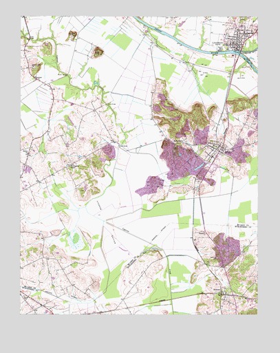
Livermore, KY USGS Topographic Map
Click on map above to begin viewing in our Map Viewer.

This topographic map contains these locations and features:
Feature Name Type Latitude Longitude GNIS ID View Map
Basin BranchStreamN37.4954°W87.1822°2743108View Map
Bates KnobSummitN37.4859°W87.2092°486468View Map
Boehler KnobSummitN37.4923°W87.2211°487611View Map
Bryant BridgeBridgeN37.4753°W87.2253°488163View Map
ButtonsberryPopulated PlaceN37.4467°W87.1686°507632View Map
Cedar HillSummitN37.4716°W87.1750°2743113View Map
Cemetery Hill (historical)SummitN37.3986°W87.1475°2742993View Map
City of IslandCivilN37.4433°W87.1474°2404769View Map
City of LivermoreCivilN37.4920°W87.1342°2404941View Map
Cypress BottomFlatN37.4153°W87.2053°490521View Map
David Lowe AirportAirportN37.3977°W87.2353°517487View Map
IslandPopulated PlaceN37.4450°W87.1439°495040View Map
Island DivisionCivilN37.4465°W87.1557°1937074View Map
LivermorePopulated PlaceN37.4931°W87.1319°496908View Map
Livermore Bridge Historical MarkerParkN37.4806°W87.1367°2744594View Map
Livermore Fire DepartmentBuildingN37.4881°W87.1342°2636409View Map
Livermore Police DepatmentBuildingN37.4879°W87.1365°2767612View Map
MoormanPopulated PlaceN37.3834°W87.1442°498570View Map
Moorman Census Designated PlaceCensusN37.3823°W87.1412°2629655View Map
New Cypress Cumberland Presbyterian ChurchChurchN37.4782°W87.2436°499310View Map
New Hope CemeteryCemeteryN37.3984°W87.1464°499338View Map
Rock HillCliffN37.4771°W87.1365°2743127View Map
Rough RiverStreamN37.4853°W87.1350°502390View Map
SemiwayPopulated PlaceN37.4734°W87.2411°509031View Map
Shavers CemeteryCemeteryN37.3828°W87.2478°503268View Map
Sketo BridgeBridgeN37.4459°W87.1978°503602View Map
Southeastern Fire DepartmentBuildingN37.4465°W87.1363°2637277View Map
StationPopulated PlaceN37.4430°W87.2457°2743130View Map
Station ChurchChurchN37.4423°W87.2461°504286View Map
StroudPopulated PlaceN37.4089°W87.1525°509151View Map
Stroud BridgeBridgeN37.4631°W87.2044°504600View Map
UnderwoodPopulated PlaceN37.4935°W87.1855°2743135View Map
Vicker BridgeBridgeN37.4903°W87.2453°506037View Map
William Worthington Historical MarkerParkN37.4455°W87.1437°2744596View Map
Worthington Chapel (historical)Populated PlaceN37.4381°W87.2232°2743136View Map
Worthington Chapel United Methodist ChurchChurchN37.4372°W87.2245°507154View Map

Note: Coordinates in the location and feature list above are referenced to NAD83 datum.


Copyright (C) 2008-2024 Ryan Niemi / Sunset Dynamics ... All Rights Reserved