TopoQuest Logo
Do you find TopoQuest useful?
Help keep TopoQuest running and adding new maps/features by donating!
Bitcoin:  19c7KJd3qBynnjoSw5npx9KScwjBe4ifkT
Litecoin:  LXs6TkuXGGXo1vDsWCkWVdjQX94eUKd6ui
Home View Maps Find Maps Find Places Resources & Links


Leandro Canyon, New Mexico Topographic Map

USGS Map Title: Leandro Canyon, NM
USGS Map MRC: 36107F2
DRG (GeoTIFF) Download: o36107f2.tif


Neighboring USGS Topographic Map Quads:


  Espinosa Ranch, NM  
36107G3
 

  Bixler Ranch, NM  
36107G2
 

  John Mills Lake, NM  
36107G1
 

  Gobernador, NM  
36107F3
 

  Leandro Canyon, NM  
36107F2
 

  Cement Lake, NM  
36107F1
 

  Vigas Canyon, NM  
36107E3
 

  Pine Lake, NM  
36107E2
 

  Leavry Canyon, NM  
36107E1


Map MRC Location:

N37°
W108°
N37°
W107°
H8 H7 H6 H5 H4 H3 H2 H1
G8 G7 G6 G5 G4 G3 G2 G1
F8 F7 F6 F5 F4 F3 F2 F1
E8 E7 E6 E5 E4 E3 E2 E1
D8 D7 D6 D5 D4 D3 D2 D1
C8 C7 C6 C5 C4 C3 C2 C1
B8 B7 B6 B5 B4 B3 B2 B1
A8 A7 A6 A5 A4 A3 A2 A1
N36°
W108°
N36°
W107°

Leandro Canyon, NM USGS 1:24K Topographic Map Preview:
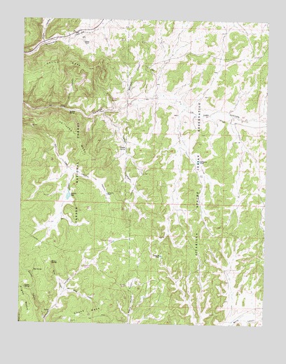
Leandro Canyon, NM USGS Topographic Map
Click on map above to begin viewing in our Map Viewer.

This topographic map contains these locations and features:
Feature Name Type Latitude Longitude GNIS ID View Map
Arnold SpringSpringN36.6675°W107.2281°902626View Map
Aspen SpringSpringN36.6303°W107.2264°907085View Map
Badland PondLakeN36.6531°W107.1785°903496View Map
Boundary CanyonValleyN36.7158°W107.1970°904027View Map
Buck CanyonValleyN36.6381°W107.2259°904129View Map
Bullsnake PondReservoirN36.6920°W107.1601°904203View Map
Caesar SpringReservoirN36.6483°W107.2172°2678779View Map
Campo CanyonValleyN36.7120°W107.2089°904329View Map
Campo SpringSpringN36.6981°W107.2000°904333View Map
Canyon SpringSpringN36.7175°W107.2053°2678782View Map
Devils CanyonValleyN36.7139°W107.2289°905729View Map
Devils MesaSummitN36.7325°W107.2353°905740View Map
GB-1 Water WellWellN36.6781°W107.2095°926487View Map
GB-2 Water WellWellN36.6781°W107.2081°926486View Map
GB-3 Water WellWellN36.6786°W107.2095°926488View Map
Gettem CanyonValleyN36.6270°W107.2370°906528View Map
Gettem SpringSpringN36.6397°W107.2478°906529View Map
Gomez TankReservoirN36.7406°W107.2198°906630View Map
Horn SpringSpringN36.6272°W107.2281°912589View Map
Horse CanyonValleyN36.6372°W107.2287°907090View Map
Horse SpringSpringN36.6497°W107.2342°907109View Map
La Jara MesaSummitN36.7031°W107.2242°907656View Map
La Jara SpringSpringN36.7121°W107.2264°2678781View Map
Laguna SecaLakeN36.6778°W107.2262°907800View Map
Leandro CanyonValleyN36.6875°W107.2237°907912View Map
Leandro TankReservoirN36.6783°W107.2067°907915View Map
Mud SpringSpringN36.6470°W107.2434°908948View Map
Paul Monarco Water WellWellN36.7147°W107.1698°926500View Map
Phones PondReservoirN36.7004°W107.1395°909605View Map
Piedra TankReservoirN36.6405°W107.1961°2678778View Map
Ruben CanyonValleyN36.7403°W107.2403°910467View Map
Valencia Canyon TankReservoirN36.6589°W107.2025°2678780View Map

Note: Coordinates in the location and feature list above are referenced to NAD83 datum.


Copyright (C) 2008-2024 Ryan Niemi / Sunset Dynamics ... All Rights Reserved