TopoQuest Logo
Do you find TopoQuest useful?
Help keep TopoQuest running and adding new maps/features by donating!
Bitcoin:  19c7KJd3qBynnjoSw5npx9KScwjBe4ifkT
Litecoin:  LXs6TkuXGGXo1vDsWCkWVdjQX94eUKd6ui
Home View Maps Find Maps Find Places Resources & Links


Pine Lake, New Mexico Topographic Map

USGS Map Title: Pine Lake, NM
USGS Map MRC: 36107E2
DRG (GeoTIFF) Download: o36107e2.tif


Neighboring USGS Topographic Map Quads:


  Gobernador, NM  
36107F3
 

  Leandro Canyon, NM  
36107F2
 

  Cement Lake, NM  
36107F1
 

  Vigas Canyon, NM  
36107E3
 

  Pine Lake, NM  
36107E2
 

  Leavry Canyon, NM  
36107E1
 

  Lapis Point, NM  
36107D3
 

  Schmitz Ranch, NM  
36107D2
 

  Ojito, NM  
36107D1


Map MRC Location:

N37°
W108°
N37°
W107°
H8 H7 H6 H5 H4 H3 H2 H1
G8 G7 G6 G5 G4 G3 G2 G1
F8 F7 F6 F5 F4 F3 F2 F1
E8 E7 E6 E5 E4 E3 E2 E1
D8 D7 D6 D5 D4 D3 D2 D1
C8 C7 C6 C5 C4 C3 C2 C1
B8 B7 B6 B5 B4 B3 B2 B1
A8 A7 A6 A5 A4 A3 A2 A1
N36°
W108°
N36°
W107°

Pine Lake, NM USGS 1:24K Topographic Map Preview:
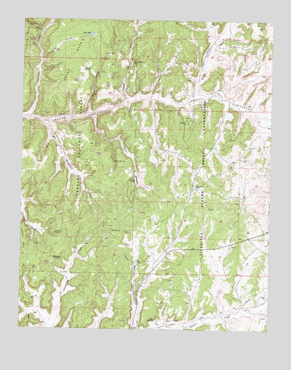
Pine Lake, NM USGS Topographic Map
Click on map above to begin viewing in our Map Viewer.

This topographic map contains these locations and features:
Feature Name Type Latitude Longitude GNIS ID View Map
Ahogadero CanyonValleyN36.5836°W107.2373°903024View Map
Ahogadero TankReservoirN36.5778°W107.2220°2678761View Map
Bee SpringSpringN36.5397°W107.2045°903718View Map
Burro CanyonValleyN36.5922°W107.1648°904237View Map
Campo SpringSpringN36.6100°W107.2092°2678769View Map
Chosa MesaSummitN36.6239°W107.2167°905127View Map
Chosa SpringSpringN36.6050°W107.2170°905129View Map
Ciruelas SpringSpringN36.5389°W107.2334°905174View Map
Ciruelas WellWellN36.5457°W107.2311°2678759View Map
Cottonwood SpringSpringN36.5286°W107.2300°905428View Map
Counting Pens Water WellWellN36.5003°W107.1931°926480View Map
Coyote LakeLakeN36.5268°W107.1924°905475View Map
Coyote SpringSpringN36.5394°W107.1983°2678755View Map
Coyote TankReservoirN36.5342°W107.1953°2678754View Map
Fierro CanyonValleyN36.5858°W107.2148°2678763View Map
Iron SpringSpringN36.5606°W107.1953°907258View Map
Jicarilla Apache Indian ReservationReserveN36.5694°W107.1600°2678752View Map
Lime SpringSpringN36.5967°W107.2139°2678765View Map
Lime TankReservoirN36.5989°W107.2092°2678764View Map
Lost CanyonValleyN36.6081°W107.2412°908238View Map
Lost LakeLakeN36.6190°W107.2169°908244View Map
Lost TankReservoirN36.6128°W107.2347°2678768View Map
Magnolia Water WellWellN36.5092°W107.1414°926482View Map
Pablo SpringSpringN36.5244°W107.2444°2678757View Map
Pablo TankReservoirN36.5261°W107.2358°2678758View Map
Piedra Blanca CanyonValleyN36.5911°W107.1978°909619View Map
Piedra Blanca SpringSpringN36.6081°W107.1950°909620View Map
Pine LakeLakeN36.5576°W107.1633°909669View Map
Pine SpringSpringN36.5039°W107.1825°909680View Map
Rim SpringSpringN36.5252°W107.2117°2678756View Map
Scissor CanyonValleyN36.6200°W107.2406°910880View Map
Scissors CorralLocaleN36.6145°W107.2442°910881View Map
Scissors SpringReservoirN36.6164°W107.2472°2678767View Map
Spruce SpringSpringN36.5678°W107.2039°911352View Map
Spruce TankReservoirN36.5706°W107.2103°2678762View Map
Theodor Serafin Water WellWellN36.5970°W107.1539°926505View Map
Valencia CanyonValleyN36.5850°W107.2462°912023View Map
Valencia SpringSpringN36.6213°W107.2441°2678770View Map
Willow CanyonValleyN36.5872°W107.2181°912400View Map
Willow SpringSpringN36.6033°W107.2170°914390View Map
Willow TankReservoirN36.6011°W107.2239°2678766View Map

Note: Coordinates in the location and feature list above are referenced to NAD83 datum.


Copyright (C) 2008-2024 Ryan Niemi / Sunset Dynamics ... All Rights Reserved