TopoQuest Logo
Do you find TopoQuest useful?
Help keep TopoQuest running and adding new maps/features by donating!
Bitcoin:  19c7KJd3qBynnjoSw5npx9KScwjBe4ifkT
Litecoin:  LXs6TkuXGGXo1vDsWCkWVdjQX94eUKd6ui
Home View Maps Find Maps Find Places Resources & Links


Lawrence, Washington Topographic Map

USGS Map Title: Lawrence, WA
USGS Map MRC: 48122G3
DRG (GeoTIFF) Download: o48122g3.tif


Neighboring USGS Topographic Map Quads:


  Lynden, WA  
48122H4
 

  Sumas, WA  
48122H3
 

  Kendall, WA  
48122H2
 

  Bellingham North, WA  
48122G4
 

  Lawrence, WA  
48122G3
 

  Deming, WA  
48122G2
 

  Bellingham South, WA  
48122F4
 

  Lake Whatcom, WA  
48122F3
 

  Acme, WA  
48122F2


Map MRC Location:

N49°
W123°
N49°
W122°
H8 H7 H6 H5 H4 H3 H2 H1
G8 G7 G6 G5 G4 G3 G2 G1
F8 F7 F6 F5 F4 F3 F2 F1
E8 E7 E6 E5 E4 E3 E2 E1
D8 D7 D6 D5 D4 D3 D2 D1
C8 C7 C6 C5 C4 C3 C2 C1
B8 B7 B6 B5 B4 B3 B2 B1
A8 A7 A6 A5 A4 A3 A2 A1
N48°
W123°
N48°
W122°

Lawrence, WA USGS 1:24K Topographic Map Preview:
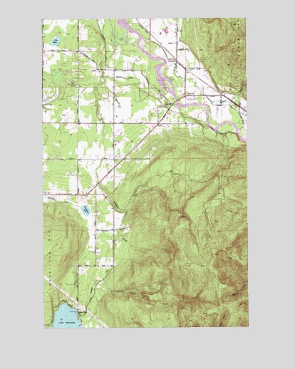
Lawrence, WA USGS Topographic Map
Click on map above to begin viewing in our Map Viewer.

This topographic map contains these locations and features:
Feature Name Type Latitude Longitude GNIS ID View Map
Agate BayPopulated PlaceN48.7559°W122.3554°1534561View Map
Anderson CreekStreamN48.8676°W122.3202°1503027View Map
Bengen QuarryMineN48.8746°W122.3000°2605654View Map
Bethany ChapelChurchN48.8440°W122.2864°2609469View Map
Carpenter CreekStreamN48.7529°W122.3557°1503817View Map
CedarvillePopulated PlaceN48.8401°W122.2957°1510866View Map
Goodwin QuarryMineN48.8639°W122.2753°2605656View Map
GoshenPopulated PlaceN48.8546°W122.3410°1511001View Map
Goshen Community ChurchChurchN48.8746°W122.3539°2609474View Map
Harmony Elementary SchoolSchoolN48.8241°W122.3317°1515175View Map
Hilltop Woodwaste LandfillLocaleN48.8513°W122.3742°2605586View Map
Hoines FarmsLocaleN48.8747°W122.3119°2704162View Map
Immanuel Lutheran ChurchChurchN48.8505°W122.2879°2609476View Map
Immanuel Lutheran PreschoolSchoolN48.8504°W122.2879°2606477View Map
J M DairyLocaleN48.8531°W122.2764°2704104View Map
Lake FazonLakeN48.8659°W122.3678°1504843View Map
Lake Whatcom Residential and Treatment CenterBuildingN48.7651°W122.3697°2607817View Map
LawrencePopulated PlaceN48.8576°W122.2935°1511093View Map
Macaulay CreekStreamN48.8404°W122.2618°1522619View Map
Nugents CornerPopulated PlaceN48.8434°W122.2882°1513944View Map
Olsen CreekStreamN48.7507°W122.3546°1507174View Map
Riverside AirportAirportN48.8359°W122.2678°2443278View Map
Rome Community Bible ChurchChurchN48.8083°W122.3436°2609276View Map
Sand Road Dairy FarmLocaleN48.8356°W122.3311°2704150View Map
Scheenstra DairyLocaleN48.8333°W122.3186°2704154View Map
Smith CreekStreamN48.8557°W122.2988°1525975View Map
Springcrest FarmLocaleN48.8600°W122.3736°2704379View Map
Squalicum LakeLakeN48.7975°W122.3501°1508652View Map
Squalicum MountainSummitN48.7821°W122.3696°1512687View Map
Stewart Mountain (not official)SummitN48.7590°W122.2679°1534161View Map
Timber Ridge CenterSchoolN48.8445°W122.3544°2518493View Map
WahlPopulated PlaceN48.8362°W122.3643°1511402View Map
Whatcom County Fire District 1 Station 82BuildingN48.8461°W122.2879°2643672View Map
Whatcom County Fire District 4 Station 11 - Agate BayBuildingN48.7554°W122.3541°2619534View Map
Whatcom County Fire District 4 Station 13BuildingN48.8332°W122.3652°2767955View Map

Note: Coordinates in the location and feature list above are referenced to NAD83 datum.


Copyright (C) 2008-2024 Ryan Niemi / Sunset Dynamics ... All Rights Reserved