TopoQuest Logo
Do you find TopoQuest useful?
Help keep TopoQuest running and adding new maps/features by donating!
Bitcoin:  19c7KJd3qBynnjoSw5npx9KScwjBe4ifkT
Litecoin:  LXs6TkuXGGXo1vDsWCkWVdjQX94eUKd6ui
Home View Maps Find Maps Find Places Resources & Links


Lake Whatcom, Washington Topographic Map

USGS Map Title: Lake Whatcom, WA
USGS Map MRC: 48122F3
DRG (GeoTIFF) Download: o48122f3.tif


Neighboring USGS Topographic Map Quads:


  Bellingham North, WA  
48122G4
 

  Lawrence, WA  
48122G3
 

  Deming, WA  
48122G2
 

  Bellingham South, WA  
48122F4
 

  Lake Whatcom, WA  
48122F3
 

  Acme, WA  
48122F2
 

  Bow, WA  
48122E4
 

  Alger, WA  
48122E3
 

  Sedro-Woolley North, WA  
48122E2


Map MRC Location:

N49°
W123°
N49°
W122°
H8 H7 H6 H5 H4 H3 H2 H1
G8 G7 G6 G5 G4 G3 G2 G1
F8 F7 F6 F5 F4 F3 F2 F1
E8 E7 E6 E5 E4 E3 E2 E1
D8 D7 D6 D5 D4 D3 D2 D1
C8 C7 C6 C5 C4 C3 C2 C1
B8 B7 B6 B5 B4 B3 B2 B1
A8 A7 A6 A5 A4 A3 A2 A1
N48°
W123°
N48°
W122°

Lake Whatcom, WA USGS 1:24K Topographic Map Preview:
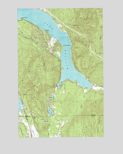
Lake Whatcom, WA USGS Topographic Map
Click on map above to begin viewing in our Map Viewer.

This topographic map contains these locations and features:
Feature Name Type Latitude Longitude GNIS ID View Map
Alger Learning Center and Independence High SchoolSchoolN48.6461°W122.3317°2606257View Map
Austin CreekStreamN48.7207°W122.3224°1503084View Map
Bear CreekStreamN48.6437°W122.3679°1503229View Map
Beaver CreekStreamN48.7118°W122.3402°1503251View Map
Blue CanyonPopulated PlaceN48.6823°W122.2774°1510828View Map
Brannian CreekStreamN48.6737°W122.2771°1503532View Map
Buckingham CreekStreamN48.6483°W122.3252°2704663View Map
Cain LakeLakeN48.6497°W122.3293°1503708View Map
Cedar AcresLocaleN48.6646°W122.3749°1511868View Map
Dutch HarborHarborN48.7282°W122.3357°1504600View Map
Fir CreekStreamN48.6726°W122.2696°1504884View Map
Floathaven AirstripAirportN48.7276°W122.3367°1533680View Map
Floathaven Seaplane BaseAirportN48.7298°W122.3510°1533681View Map
Glenhaven Lakes DamDamN48.6565°W122.3313°1532196View Map
Lake LouiseReservoirN48.7089°W122.3274°1513464View Map
Lake Louise SubstationLocaleN48.7186°W122.3541°2606836View Map
Lake WhatcomLakeN48.7402°W122.3458°1531537View Map
Lookout MountainSummitN48.6887°W122.3607°1506306View Map
Louise Lake DamDamN48.7115°W122.3263°1532151View Map
Palmer LakeLakeN48.6410°W122.3401°1507265View Map
ParkLocaleN48.6754°W122.2663°1507296View Map
Reed LakeReservoirN48.6619°W122.3279°1513476View Map
Reveille IslandIslandN48.7134°W122.3088°1507787View Map
Rufus CreekStreamN48.7200°W122.3543°2740446View Map
Smith CreekStreamN48.7290°W122.3154°1508426View Map
South BayBayN48.6765°W122.3141°1508502View Map
South Whatcom Fire Authority Station 22BuildingN48.7158°W122.3323°2643607View Map
Squires LakeLakeN48.6455°W122.3535°1508673View Map
Strawberry PointCapeN48.7415°W122.3707°1508774View Map
Sudden ValleyPopulated PlaceN48.7229°W122.3466°1514482View Map
Sudden Valley Census Designated PlaceCensusN48.7199°W122.3468°2410015View Map
Sudden Valley Golf ClubLocaleN48.7172°W122.3271°2608197View Map
SunnysidePopulated PlaceN48.7312°W122.3154°1511347View Map
Whatcom County Fire District 18 Fire Station 25BuildingN48.6732°W122.3155°2643613View Map
Whatcom County Fire District 18 Station 26BuildingN48.6572°W122.3251°2643614View Map

Note: Coordinates in the location and feature list above are referenced to NAD83 datum.


Copyright (C) 2008-2024 Ryan Niemi / Sunset Dynamics ... All Rights Reserved