TopoQuest Logo
Do you find TopoQuest useful?
Help keep TopoQuest running and adding new maps/features by donating!
Bitcoin:  19c7KJd3qBynnjoSw5npx9KScwjBe4ifkT
Litecoin:  LXs6TkuXGGXo1vDsWCkWVdjQX94eUKd6ui
Home View Maps Find Maps Find Places Resources & Links


Lancaster, Illinois Topographic Map

USGS Map Title: Lancaster, IL
USGS Map MRC: 38087E7
DRG (GeoTIFF) Download: o38087e7.tif


Neighboring USGS Topographic Map Quads:


  Claremont, IL  
38087F8
 

  Sumner, IL  
38087F7
 

  Lawrenceville, IL  
38087F6
 

  Berryville, IL  
38087E8
 

  Lancaster, IL  
38087E7
 

  Saint Francisville, IL  
38087E6
 

  Bone Gap, IL  
38087D8
 

  Mount Carmel, IL  
38087D7
 

  East Mount Carmel, IN  
38087D6


Map MRC Location:

N39°
W88°
N39°
W87°
H8 H7 H6 H5 H4 H3 H2 H1
G8 G7 G6 G5 G4 G3 G2 G1
F8 F7 F6 F5 F4 F3 F2 F1
E8 E7 E6 E5 E4 E3 E2 E1
D8 D7 D6 D5 D4 D3 D2 D1
C8 C7 C6 C5 C4 C3 C2 C1
B8 B7 B6 B5 B4 B3 B2 B1
A8 A7 A6 A5 A4 A3 A2 A1
N38°
W88°
N38°
W87°

Lancaster, IL USGS 1:24K Topographic Map Preview:
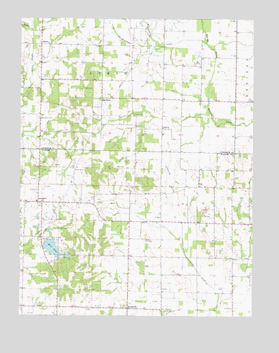
Lancaster, IL USGS Topographic Map
Click on map above to begin viewing in our Map Viewer.

This topographic map contains these locations and features:
Feature Name Type Latitude Longitude GNIS ID View Map
Barneys Prairie ChurchChurchN38.5023°W87.7970°403920View Map
Besley School (historical)SchoolN38.5178°W87.7909°1725667View Map
Bethel CemeteryCemeteryN38.5795°W87.7986°1934554View Map
Bethel ChurchChurchN38.5789°W87.7984°404296View Map
Blackoak School (historical)SchoolN38.5289°W87.8456°1725668View Map
Clark CemeteryCemeteryN38.5548°W87.8150°406151View Map
Cleveland School (historical)SchoolN38.5987°W87.8317°1764755View Map
Corrie CemeteryCemeteryN38.5956°W87.8403°406603View Map
Couch School (historical)SchoolN38.5470°W87.8164°1725670View Map
Craig Farm CemeteryCemeteryN38.5552°W87.7745°2045779View Map
Denison Fire Protection District Station 2BuildingN38.5939°W87.7593°2682313View Map
Fish LakeReservoirN38.5252°W87.8496°1692136View Map
Fish Lake DamDamN38.5250°W87.8500°1692135View Map
FriendsvillePopulated PlaceN38.5031°W87.8164°408767View Map
Friendsville CemeteryCemeteryN38.5039°W87.8178°2045803View Map
Friendsville Election PrecinctCivilN38.5127°W87.8075°1928500View Map
Frogeye School (historical)SchoolN38.5909°W87.7989°1764765View Map
Harmony School (historical)SchoolN38.5906°W87.7595°1764771View Map
HelenaPopulated PlaceN38.6142°W87.8639°422795View Map
LancasterPopulated PlaceN38.5478°W87.8653°411789View Map
Lancaster Post OfficePost OfficeN38.5475°W87.8648°1823667View Map
Lukin TownhallBuildingN38.6137°W87.8348°1764784View Map
McNair School (historical)SchoolN38.5248°W87.8156°1725674View Map
Mesa LakeReservoirN38.5285°W87.8576°413448View Map
Mesa Lake DamDamN38.5309°W87.8611°1691432View Map
Moffett CemeteryCemeteryN38.5848°W87.8142°413703View Map
New Lancaster CemeteryCemeteryN38.5478°W87.8722°2045792View Map
Old Hickory School (historical)SchoolN38.5353°W87.7709°1725676View Map
Oreo CemeteryCemeteryN38.5552°W87.7746°2045815View Map
OrioPopulated PlaceN38.5545°W87.7789°415171View Map
Orio School (historical)SchoolN38.5617°W87.7792°1725677View Map
PetersburgPopulated PlaceN38.5917°W87.8311°415577View Map
Ridgely CemeteryCemeteryN38.5528°W87.8097°416648View Map
Stoltz School (historical)SchoolN38.5034°W87.8736°1725678View Map
Storckman CemeteryCemeteryN38.5831°W87.8634°419192View Map
Storckman CreekStreamN38.6150°W87.7759°419193View Map
Sugar CreekStreamN38.6198°W87.8684°419275View Map
Township of LukinCivilN38.6137°W87.8347°429291View Map
West Ruark Oil FieldOilfieldN38.6117°W87.8042°425631View Map
White Pine School (historical)SchoolN38.5653°W87.8231°1725679View Map
White School (historical)SchoolN38.5848°W87.8648°1764812View Map

Note: Coordinates in the location and feature list above are referenced to NAD83 datum.


Copyright (C) 2008-2024 Ryan Niemi / Sunset Dynamics ... All Rights Reserved