TopoQuest Logo
Do you find TopoQuest useful?
Help keep TopoQuest running and adding new maps/features by donating!
Bitcoin:  19c7KJd3qBynnjoSw5npx9KScwjBe4ifkT
Litecoin:  LXs6TkuXGGXo1vDsWCkWVdjQX94eUKd6ui
Home View Maps Find Maps Find Places Resources & Links


Lawrenceville, Illinois Topographic Map

USGS Map Title: Lawrenceville, IL
USGS Map MRC: 38087F6
DRG (GeoTIFF) Download: o38087f6.tif


Neighboring USGS Topographic Map Quads:


  Chauncey, IL  
38087G7
 

  Birds, IL  
38087G6
 

  Russellville, IL  
38087G5
 

  Sumner, IL  
38087F7
 

  Lawrenceville, IL  
38087F6
 

  Vincennes, IN  
38087F5
 

  Lancaster, IL  
38087E7
 

  Saint Francisville, IL  
38087E6
 

  Decker, IN  
38087E5


Map MRC Location:

N39°
W88°
N39°
W87°
H8 H7 H6 H5 H4 H3 H2 H1
G8 G7 G6 G5 G4 G3 G2 G1
F8 F7 F6 F5 F4 F3 F2 F1
E8 E7 E6 E5 E4 E3 E2 E1
D8 D7 D6 D5 D4 D3 D2 D1
C8 C7 C6 C5 C4 C3 C2 C1
B8 B7 B6 B5 B4 B3 B2 B1
A8 A7 A6 A5 A4 A3 A2 A1
N38°
W88°
N38°
W87°

Lawrenceville, IL USGS 1:24K Topographic Map Preview:
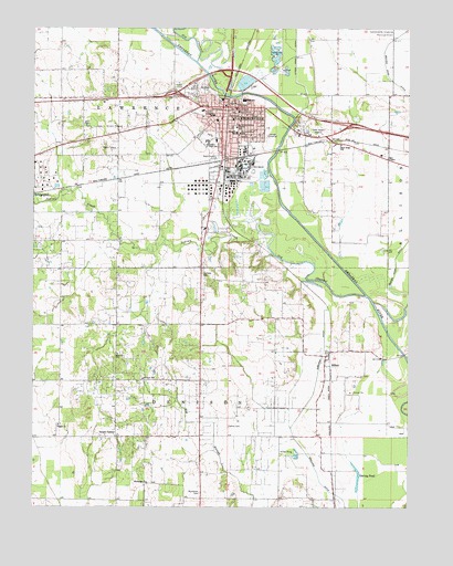
Lawrenceville, IL USGS Topographic Map
Click on map above to begin viewing in our Map Viewer.

This topographic map contains these locations and features:
Feature Name Type Latitude Longitude GNIS ID View Map
Arlington Elementary SchoolSchoolN38.7273°W87.6895°403614View Map
BillettPopulated PlaceN38.6645°W87.6522°404445View Map
Billett School (historical)SchoolN38.6742°W87.6697°1764746View Map
Billett United Methodist ChurchChurchN38.6637°W87.6525°1816166View Map
Buchanan CemeteryCemeteryN38.6287°W87.6942°405081View Map
Buchanan ChurchChurchN38.6317°W87.7120°405082View Map
Buchanan School (historical)SchoolN38.6314°W87.7122°1764749View Map
Central Elementary SchoolSchoolN38.7242°W87.6820°405879View Map
City of LawrencevilleCivilN38.7263°W87.6874°2395649View Map
Collins CemeteryCemeteryN38.6459°W87.6847°406377View Map
Collins School (historical)SchoolN38.6439°W87.6845°1764756View Map
Crossroads School (historical)SchoolN38.7231°W87.7214°1764758View Map
Dunlap Airport (historical)AirportN38.7250°W87.7439°427085View Map
England DitchCanalN38.6387°W87.6584°408027View Map
Faith Church of the NazareneChurchN38.7270°W87.6936°1816172View Map
Fillmore SchoolSchoolN38.6584°W87.7131°408368View Map
First Baptist ChurchChurchN38.7275°W87.6792°1816173View Map
First Christian ChurchChurchN38.7298°W87.6861°1816174View Map
First Church of GodChurchN38.7175°W87.6878°1816176View Map
First Presbyterian ChurchChurchN38.7284°W87.6836°1816177View Map
First United Methodist ChurchChurchN38.7262°W87.6836°1816179View Map
Free Methodist ChurchChurchN38.7259°W87.6814°1816182View Map
Fremont School (historical)SchoolN38.6873°W87.7142°1764764View Map
Garvey PondLakeN38.6354°W87.6425°408919View Map
Grays CornerPopulated PlaceN38.6434°W87.7220°409356View Map
Grisold (historical)Populated PlaceN38.7153°W87.6875°1816183View Map
Hi-Way Church of GodChurchN38.7328°W87.7133°2761078View Map
Hollister CemeteryCemeteryN38.6856°W87.6936°410401View Map
Indian CreekStreamN38.6931°W87.6720°410842View Map
Indian HeliportAirportN38.7145°W87.6772°427440View Map
JacksonPopulated PlaceN38.7212°W87.6503°1764776View Map
Lawrence - Allison Fire Protection DistrictBuildingN38.7302°W87.6826°2682367View Map
Lawrence - Allison Fire Protection District Station 2BuildingN38.7250°W87.6326°2682316View Map
Lawrence Co Memorial Hospital HeliportAirportN38.7281°W87.6947°427439View Map
Lawrence CountyCivilN38.7199°W87.7267°424252View Map
Lawrence County CourthouseBuildingN38.7289°W87.6825°1764779View Map
Lawrence County Memorial HospitalHospitalN38.7287°W87.6938°1816186View Map
Lawrence County Sheriff's OfficeBuildingN38.7268°W87.6851°2758952View Map
Lawrence Public LibaryBuildingN38.7281°W87.6831°1816187View Map
LawrencevillePopulated PlaceN38.7292°W87.6817°411873View Map
Lawrenceville CemeteryCemeteryN38.7348°W87.6928°1934560View Map
Lawrenceville City HallBuildingN38.7300°W87.6822°1764780View Map
Lawrenceville High SchoolSchoolN38.7328°W87.6800°1816188View Map
Lawrenceville Post OfficePost OfficeN38.7283°W87.6817°1764781View Map
Lincoln Elementary SchoolSchoolN38.7228°W87.6822°412150View Map
May ChapelChurchN38.7162°W87.6320°413151View Map
May Chapel CemeteryCemeteryN38.7153°W87.6322°1934556View Map
Otterbein United Methodist ChurchChurchN38.7248°W87.6817°1816190View Map
Our Savior Lutheran ChurchChurchN38.7231°W87.6878°1816191View Map
Parkview Junior High SchoolSchoolN38.7206°W87.6917°415412View Map
Piper's LandingAirportN38.7099°W87.6326°2679058View Map
Pisgah ChurchChurchN38.6464°W87.7414°415740View Map
Saint Lawrence Catholic ChurchChurchN38.7223°W87.6817°1816195View Map
Saint Lawrence SchoolSchoolN38.7225°W87.6811°417505View Map
Sand Ridge SchoolSchoolN38.7195°W87.6475°417949View Map
Shoal Tract (historical)AreaN38.7223°W87.6953°1816197View Map
Township of DenisonCivilN38.6280°W87.6935°428887View Map
Township of LawrenceCivilN38.7325°W87.6946°429236View Map
WAKO-AM (Lawrenceville)TowerN38.7231°W87.6536°428031View Map
WAKO-FM (Lawrenceville)TowerN38.7231°W87.6536°428221View Map
Zion United Methodist ChurchChurchN38.6648°W87.7217°421649View Map

Note: Coordinates in the location and feature list above are referenced to NAD83 datum.


Copyright (C) 2008-2024 Ryan Niemi / Sunset Dynamics ... All Rights Reserved