TopoQuest Logo
Do you find TopoQuest useful?
Help keep TopoQuest running and adding new maps/features by donating!
Bitcoin:  19c7KJd3qBynnjoSw5npx9KScwjBe4ifkT
Litecoin:  LXs6TkuXGGXo1vDsWCkWVdjQX94eUKd6ui
Home View Maps Find Maps Find Places Resources & Links


Lakeside Village, Virginia Topographic Map

USGS Map Title: Lakeside Village, VA
USGS Map MRC: 37078F2
DRG (GeoTIFF) Download: o37078f2.tif


Neighboring USGS Topographic Map Quads:


  Palmyra, VA  
37078G3
 

  Columbia, VA  
37078G2
 

  Caledonia, VA  
37078G1
 

  Arvonia, VA  
37078F3
 

  Lakeside Village, VA  
37078F2
 

  Cartersville, VA  
37078F1
 

  Gold Hill, VA  
37078E3
 

  Whiteville, VA  
37078E2
 

  Trenholm, VA  
37078E1


Map MRC Location:

N38°
W79°
N38°
W78°
H8 H7 H6 H5 H4 H3 H2 H1
G8 G7 G6 G5 G4 G3 G2 G1
F8 F7 F6 F5 F4 F3 F2 F1
E8 E7 E6 E5 E4 E3 E2 E1
D8 D7 D6 D5 D4 D3 D2 D1
C8 C7 C6 C5 C4 C3 C2 C1
B8 B7 B6 B5 B4 B3 B2 B1
A8 A7 A6 A5 A4 A3 A2 A1
N37°
W79°
N37°
W78°

Lakeside Village, VA USGS 1:24K Topographic Map Preview:
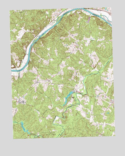
Lakeside Village, VA USGS Topographic Map
Click on map above to begin viewing in our Map Viewer.

This topographic map contains these locations and features:
Feature Name Type Latitude Longitude GNIS ID View Map
Big Cattail CreekStreamN37.6676°W78.1708°1463334View Map
Boatwrights IslandIslandN37.7221°W78.2164°1463620View Map
Boston BranchStreamN37.6893°W78.1406°1463686View Map
Boswell (historical)Populated PlaceN37.6965°W78.2292°1493946View Map
Bush Park (historical)Populated PlaceN37.6360°W78.1394°1494100View Map
Cartersville Volunteer Rescue SquadBuildingN37.6343°W78.1399°2331914View Map
Cartersville Volunteer Rescue SquadBuildingN37.6343°W78.1402°2075463View Map
Cloverdale Baptist ChurchChurchN37.7485°W78.2308°1494056View Map
Cobbs CreekStreamN37.7346°W78.1919°1465029View Map
Cochran CemeteryCemeteryN37.6360°W78.1369°1465036View Map
Cremona (historical)Populated PlaceN37.7190°W78.1597°1493947View Map
District 1CivilN37.6584°W78.1689°1927178View Map
Duncans StoreLocaleN37.6804°W78.2031°1466044View Map
Flat Rock School (historical)SchoolN37.6863°W78.1964°1494116View Map
Fork of Willis ChurchChurchN37.7165°W78.1686°1466771View Map
Georgia BranchStreamN37.6418°W78.2483°1467050View Map
Hamilton High School (historical)SchoolN37.6585°W78.1272°1494125View Map
Harrison CemeteryCemeteryN37.6790°W78.1264°1494126View Map
Hooper Rock CreekStreamN37.7443°W78.1494°1468218View Map
James River Batteau Festival TrailTrailN37.7310°W78.2011°1498409View Map
Lakeside VillagePopulated PlaceN37.6635°W78.1783°1495810View Map
Leon Hanson DamDamN37.7401°W78.1514°1489562View Map
Leon Hanson PondReservoirN37.7382°W78.1532°1489563View Map
Little Cattail CreekStreamN37.6563°W78.1969°1469496View Map
Little Fork CemeteryCemeteryN37.7196°W78.1511°1760982View Map
Little Fork ChurchChurchN37.7188°W78.1497°1469543View Map
Mount Horeb ChurchChurchN37.6260°W78.1417°1470910View Map
Mullins Botton School (historical)SchoolN37.7035°W78.1781°1494145View Map
North CreekStreamN37.7454°W78.2053°1471591View Map
Oakwood ChurchChurchN37.7068°W78.1753°1471800View Map
Pleasant View ChurchChurchN37.6793°W78.2186°1472518View Map
Punch CreekStreamN37.7160°W78.2214°1472860View Map
Randolph CreekStreamN37.6268°W78.2242°1472962View Map
Robertson DamDamN37.6468°W78.1314°1489585View Map
Snowquarter CreekStreamN37.6560°W78.1722°1474815View Map
South CreekStreamN37.7396°W78.1908°1474846View Map
Spicers IslandIslandN37.7185°W78.2206°1474944View Map
Sports DamDamN37.6296°W78.2294°1489551View Map
Sports LakeReservoirN37.6327°W78.2347°1502135View Map
StearnesPopulated PlaceN37.7004°W78.2389°1496254View Map
Trenton MillsPopulated PlaceN37.6293°W78.2283°1496322View Map
Trice DamDamN37.6685°W78.1742°1489537View Map
Trice LakeReservoirN37.6641°W78.1811°1502147View Map
Trices Mill (historical)LocaleN37.6676°W78.1750°1494170View Map

Note: Coordinates in the location and feature list above are referenced to NAD83 datum.


Copyright (C) 2008-2024 Ryan Niemi / Sunset Dynamics ... All Rights Reserved