TopoQuest Logo
Do you find TopoQuest useful?
Help keep TopoQuest running and adding new maps/features by donating!
Bitcoin:  19c7KJd3qBynnjoSw5npx9KScwjBe4ifkT
Litecoin:  LXs6TkuXGGXo1vDsWCkWVdjQX94eUKd6ui
Home View Maps Find Maps Find Places Resources & Links


Lake Ashby, Florida Topographic Map

USGS Map Title: Lake Ashby, FL
USGS Map MRC: 28081H1
DRG (GeoTIFF) Download: o28081h1.tif


Neighboring USGS Topographic Map Quads:


  Daytona Beach SW, FL  
29081A2
 

  Samsula, FL  
29081A1
 

  New Smyrna Beach, FL  
29080A8
 

  Lake Helen, FL  
28081H2
 

  Lake Ashby, FL  
28081H1
 

  Edgewater, FL  
28080H8
 

  Osteen, FL  
28081G2
 

  Osceola, FL  
28081G1
 

  Maytown, FL  
28080G8


Map MRC Location:

N29°
W82°
N29°
W81°
H8 H7 H6 H5 H4 H3 H2 H1
G8 G7 G6 G5 G4 G3 G2 G1
F8 F7 F6 F5 F4 F3 F2 F1
E8 E7 E6 E5 E4 E3 E2 E1
D8 D7 D6 D5 D4 D3 D2 D1
C8 C7 C6 C5 C4 C3 C2 C1
B8 B7 B6 B5 B4 B3 B2 B1
A8 A7 A6 A5 A4 A3 A2 A1
N28°
W82°
N28°
W81°

Lake Ashby, FL USGS 1:24K Topographic Map Preview:
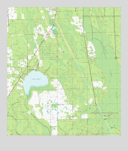
Lake Ashby, FL USGS Topographic Map
Click on map above to begin viewing in our Map Viewer.

This topographic map contains these locations and features:
Feature Name Type Latitude Longitude GNIS ID View Map
AlamanaPopulated PlaceN28.9430°W81.1026°294647View Map
Ashby Lookout TowerTowerN28.9053°W81.0689°277967View Map
Buzzards Roost LakeLakeN28.8835°W81.0107°279776View Map
Harris BaySwampN28.9005°W81.0356°283758View Map
Lake AshbyLakeN28.9290°W81.0946°277968View Map
Lake Ashby CanalCanalN28.8903°W81.0914°285217View Map
Lake Ashby CreekStreamN28.9380°W81.0937°285218View Map
Lake Ashby Mobile Home ParkPopulated PlaceN28.9350°W81.1045°2451156View Map
Lake Ashby ShoresPopulated PlaceN28.9394°W81.0942°295397View Map
Leffler AirportAirportN28.9630°W81.1191°309223View Map
Long IslandIslandN28.9897°W81.0301°307387View Map
Opossum CampLocaleN28.9511°W81.0053°288179View Map
Rattlesnake IslandIslandN28.8911°W81.0189°289491View Map
Samsula CampLocaleN28.9500°W81.0345°290467View Map
Samsula CanalCanalN28.9614°W81.0376°290468View Map
Sandy DrainStreamN28.8761°W81.0776°290614View Map
Watson IslandIslandN28.8944°W81.0145°292943View Map

Note: Coordinates in the location and feature list above are referenced to NAD83 datum.


Copyright (C) 2008-2024 Ryan Niemi / Sunset Dynamics ... All Rights Reserved