TopoQuest Logo
Do you find TopoQuest useful?
Help keep TopoQuest running and adding new maps/features by donating!
Bitcoin:  19c7KJd3qBynnjoSw5npx9KScwjBe4ifkT
Litecoin:  LXs6TkuXGGXo1vDsWCkWVdjQX94eUKd6ui
Home View Maps Find Maps Find Places Resources & Links


Osteen, Florida Topographic Map

USGS Map Title: Osteen, FL
USGS Map MRC: 28081G2
DRG (GeoTIFF) Download: o28081g2.tif


Neighboring USGS Topographic Map Quads:


  Orange City, FL  
28081H3
 

  Lake Helen, FL  
28081H2
 

  Lake Ashby, FL  
28081H1
 

  Sanford, FL  
28081G3
 

  Osteen, FL  
28081G2
 

  Osceola, FL  
28081G1
 

  Casselberry, FL  
28081F3
 

  Oviedo, FL  
28081F2
 

  Geneva, FL  
28081F1


Map MRC Location:

N29°
W82°
N29°
W81°
H8 H7 H6 H5 H4 H3 H2 H1
G8 G7 G6 G5 G4 G3 G2 G1
F8 F7 F6 F5 F4 F3 F2 F1
E8 E7 E6 E5 E4 E3 E2 E1
D8 D7 D6 D5 D4 D3 D2 D1
C8 C7 C6 C5 C4 C3 C2 C1
B8 B7 B6 B5 B4 B3 B2 B1
A8 A7 A6 A5 A4 A3 A2 A1
N28°
W82°
N28°
W81°

Osteen, FL USGS 1:24K Topographic Map Preview:
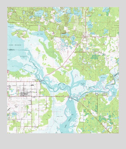
Osteen, FL USGS Topographic Map
Click on map above to begin viewing in our Map Viewer.

This topographic map contains these locations and features:
Feature Name Type Latitude Longitude GNIS ID View Map
Acorn Fish LakeLakeN28.8733°W81.1404°277666View Map
Beany PondLakeN28.8605°W81.2143°298609View Map
Beardell Avenue ChapelChurchN28.7714°W81.2226°278349View Map
Beck HammockPopulated PlaceN28.7869°W81.2184°295121View Map
Beck HammockIslandN28.7939°W81.2067°301336View Map
Bethel CreekStreamN28.8514°W81.2453°278553View Map
Bethel Creek CoveBayN28.8555°W81.2444°278556View Map
Big LakeLakeN28.8690°W81.2140°278702View Map
Big Smokehouse CoveBayN28.8267°W81.2312°278748View Map
Black LakeLakeN28.8676°W81.1466°278908View Map
BodenPopulated PlaceN28.8350°W81.1259°301657View Map
Brickyard SloughGutN28.8000°W81.1890°304992View Map
Brisson Railroad StationLocaleN28.7975°W81.2406°301331View Map
Broken Arrow LakeLakeN28.8694°W81.2311°2765177View Map
Cameron CityPopulated PlaceN28.7569°W81.2187°279869View Map
CanaanPopulated PlaceN28.7903°W81.2226°279960View Map
Cedar Knoll Flying Ranch AirportAirportN28.7846°W81.1595°2676632View Map
Chaco Railroad StationLocaleN28.7975°W81.2209°301333View Map
Christ Wesleyan ChurchChurchN28.8635°W81.2325°2448743View Map
Chub CreekStreamN28.7580°W81.1909°280440View Map
Coffey SloughBayN28.7871°W81.1648°280630View Map
Dixon LakeLakeN28.8492°W81.1543°281613View Map
Fellowship Baptist ChurchChurchN28.8594°W81.1854°2448753View Map
First Baptist Church of OsteenChurchN28.8433°W81.1595°299615View Map
First Spanish Baptist Church of DeltonaChurchN28.8706°W81.2274°2448755View Map
Garfield Settlement CemeteryCemeteryN28.8683°W81.2264°2581933View Map
Geigers LandingPopulated PlaceN28.7894°W81.1478°283002View Map
Geneva BridgeBridgeN28.7858°W81.1801°283013View Map
Glorious United Pentecostal Church of GodChurchN28.8463°W81.1495°2451634View Map
Golden LakeLakeN28.7688°W81.2425°283154View Map
Grassy PointCapeN28.7689°W81.1784°283334View Map
Grassy PointCapeN28.8228°W81.2467°283335View Map
Hickmans LandingLocaleN28.8222°W81.1284°301656View Map
Hickory SloughGutN28.7967°W81.1548°283969View Map
Indian Mound SloughGutN28.8011°W81.2117°284521View Map
Indian Mound VillagePopulated PlaceN28.8033°W81.2167°284523View Map
Iron BendBendN28.8208°W81.1267°284592View Map
Jacksons BayLakeN28.8511°W81.1396°284696View Map
Jenkins PondLakeN28.8654°W81.2231°284748View Map
Lake BethelLakeN28.8478°W81.2127°278560View Map
Lake Butler ChainLakeN28.8748°W81.1844°279737View Map
Lake DoyleLakeN28.8620°W81.1938°281745View Map
Lake EulaliaLakeN28.8671°W81.1590°282271View Map
Lake HutchinsonLakeN28.8479°W81.1844°284436View Map
Lake OnoraLakeN28.7679°W81.2485°288161View Map
Lemon BluffPopulated PlaceN28.8064°W81.1320°285454View Map
Lemon Bluff Fishing Campground MarinaHarborN28.8067°W81.1315°2451633View Map
Little LakeLakeN28.8423°W81.1759°285721View Map
MidwayPopulated PlaceN28.7903°W81.2309°286824View Map
Midway Census Designated PlaceCensusN28.7924°W81.2313°2403289View Map
Midway Elementary SchoolSchoolN28.7886°W81.2406°299219View Map
Monroe CanalCanalN28.8114°W81.2262°287067View Map
Moores Railroad Station (historical)LocaleN28.7725°W81.2184°301334View Map
Mothers ArmsIslandN28.8222°W81.2342°305018View Map
Mud LakeLakeN28.8053°W81.1426°287411View Map
Mullet LakeLakeN28.7905°W81.1315°287461View Map
Mullet Lake ParkPopulated PlaceN28.7892°W81.1384°287462View Map
Naked PlaceSwampN28.7570°W81.2095°287520View Map
Naval Air Station Sanford (historical)MilitaryN28.7772°W81.2478°2100103View Map
Orlando Sanford International AirportAirportN28.7762°W81.2432°309785View Map
Orlando Sanford International Airport Authority Fire Department Station 51BuildingN28.7774°W81.2307°2331272View Map
OsteenPopulated PlaceN28.8461°W81.1626°288269View Map
Osteen BridgeBridgeN28.8028°W81.2103°288270View Map
Osteen Elementary SchoolSchoolN28.8555°W81.1758°299404View Map
Osteen Post OfficePost OfficeN28.8450°W81.1602°2451632View Map
Outlook LakeLakeN28.8720°W81.2446°288301View Map
Palm ShadowsPopulated PlaceN28.7886°W81.1428°288410View Map
Panama LakeLakeN28.8683°W81.2278°288449View Map
Paradise Lakes Travel Trailer ParkPopulated PlaceN28.8699°W81.2290°2448740View Map
Prairie LandingLocaleN28.8003°W81.1895°305006View Map
River Greens Golf CourseLocaleN28.8473°W81.1405°2451631View Map
Roseland ParkPopulated PlaceN28.7964°W81.2465°301125View Map
Rotten Egg SloughBayN28.7572°W81.1777°289987View Map
Saint Johns LakeLakeN28.8699°W81.2268°290232View Map
Saint Pauls ChurchChurchN28.8583°W81.2290°290344View Map
Sanford International Airport Police DepartmentBuildingN28.7748°W81.2452°2756099View Map
Seminole County Fire Department Station 41BuildingN28.7861°W81.2301°2331280View Map
Sipes Railroad StationLocaleN28.7978°W81.2212°301332View Map
Snake CreekGutN28.7961°W81.1615°291284View Map
Stone IslandIslandN28.8500°W81.2359°291721View Map
Tanner LakeLakeN28.8683°W81.2237°292024View Map
The SavannahLakeN28.8580°W81.1575°292181View Map
Thompson LakeLakeN28.8738°W81.1566°292226View Map
Thormpson PondLakeN28.8644°W81.2348°298610View Map
Thornhill LakeLakeN28.7999°W81.1689°292234View Map
Three Otter CreekStreamN28.7539°W81.1912°292248View Map
Tyler LakeLakeN28.8343°W81.1603°292627View Map
Volusia County Fire Services Station 34 Indian MoundBuildingN28.8572°W81.2248°2331221View Map
Volusia County Fire Services Station 36 OsteenBuildingN28.8465°W81.1630°2331223View Map
WESH-TV (Daytona Beach)TowerN28.8422°W81.1317°310288View Map
Woodruff CreekStreamN28.8153°W81.2345°293517View Map

Note: Coordinates in the location and feature list above are referenced to NAD83 datum.


Copyright (C) 2008-2024 Ryan Niemi / Sunset Dynamics ... All Rights Reserved