TopoQuest Logo
Do you find TopoQuest useful?
Help keep TopoQuest running and adding new maps/features by donating!
Bitcoin:  19c7KJd3qBynnjoSw5npx9KScwjBe4ifkT
Litecoin:  LXs6TkuXGGXo1vDsWCkWVdjQX94eUKd6ui
Home View Maps Find Maps Find Places Resources & Links


King And Queen Court House, Virginia Topographic Map

USGS Map Title: King And Queen Court House, VA
USGS Map MRC: 37076F8
DRG (GeoTIFF) Download: o37076f8.tif


Neighboring USGS Topographic Map Quads:


  Aylett, VA  
37077G1
 

  Millers Tavern, VA  
37076G8
 

  Dunnsville, VA  
37076G7
 

  King William, VA  
37077F1
 

  King And Queen Court House, VA  
37076F8
 

  Truhart, VA  
37076F7
 

  Tunstall, VA  
37077E1
 

  New Kent, VA  
37076E8
 

  West Point, VA  
37076E7


Map MRC Location:

N38°
W77°
N38°
W76°
H8 H7 H6 H5 H4 H3 H2 H1
G8 G7 G6 G5 G4 G3 G2 G1
F8 F7 F6 F5 F4 F3 F2 F1
E8 E7 E6 E5 E4 E3 E2 E1
D8 D7 D6 D5 D4 D3 D2 D1
C8 C7 C6 C5 C4 C3 C2 C1
B8 B7 B6 B5 B4 B3 B2 B1
A8 A7 A6 A5 A4 A3 A2 A1
N37°
W77°
N37°
W76°

King And Queen Court House, VA USGS 1:24K Topographic Map Preview:
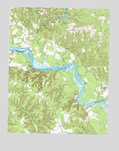
King And Queen Court House, VA USGS Topographic Map
Click on map above to begin viewing in our Map Viewer.

This topographic map contains these locations and features:
Feature Name Type Latitude Longitude GNIS ID View Map
Brooks CreekStreamN37.6751°W76.9108°1463891View Map
Central High SchoolSchoolN37.6742°W76.8829°1464694View Map
Colosse ChurchChurchN37.6582°W76.9511°1465120View Map
Courthouse CreekStreamN37.6590°W76.8844°1465317View Map
Courthouse LandingPopulated PlaceN37.6579°W76.8797°1495431View Map
CumnorPopulated PlaceN37.7251°W76.8833°1495449View Map
Dahlgrens CornerPopulated PlaceN37.7090°W76.9247°1477242View Map
De Farges BarBarN37.6913°W76.9366°1465668View Map
Dickeys SwampStreamN37.7335°W76.9647°1465779View Map
Duck PondLakeN37.7240°W76.9686°1466019View Map
Frog Hollow Farm Airport (historical)AirportN37.6951°W76.9950°1498849View Map
Frog Hollow Sod FarmLocaleN37.6953°W76.9939°2676064View Map
Garnetts CreekStreamN37.6901°W76.9525°1467003View Map
Garretts DamDamN37.6901°W76.9747°1490226View Map
Gleason MarshSwampN37.6489°W76.8764°1467139View Map
HillsboroPopulated PlaceN37.7101°W76.9827°1480213View Map
Horse LandingPopulated PlaceN37.7060°W76.9936°1477424View Map
Ice House DamDamN37.7468°W76.9314°1490183View Map
Indian Mound PondsReservoirN37.7319°W76.9537°1468476View Map
Indian Mound Ponds DamDamN37.7329°W76.9547°1490186View Map
Indian Town SwampStreamN37.6663°W76.9136°1468491View Map
King and Queen CountyCivilN37.7186°W76.8953°1480136View Map
King and Queen County Emergency Services CoordinatorBuildingN37.6684°W76.8771°2331889View Map
King and Queen County Sheriff's OfficeBuildingN37.6692°W76.8769°2331947View Map
King and Queen Court HousePopulated PlaceN37.6699°W76.8775°1498499View Map
King and Queen Court House Census Designated PlaceCensusN37.6683°W76.8781°2628835View Map
King and Queen Court House Post OfficePost OfficeN37.6702°W76.8756°2519624View Map
King and Queen Courthouse DamDamN37.6735°W76.8780°1490163View Map
King and Queen Courthouse PondReservoirN37.6756°W76.8785°1490164View Map
Log LandingPopulated PlaceN37.6760°W76.9047°1495864View Map
Lower King and Queen Volunteer Fire DepartmentBuildingN37.6654°W76.9652°2331885View Map
Madison CreekStreamN37.6863°W76.9525°1470000View Map
MantapikePopulated PlaceN37.6965°W76.9208°1495896View Map
Mantapike CreekStreamN37.6932°W76.9283°1470058View Map
Mantapike LandingLocaleN37.6957°W76.9208°1739305View Map
Mantua FerryLocaleN37.6951°W76.9727°1470061View Map
Market SwampStreamN37.7335°W76.9647°1470096View Map
Mattaponi ChurchChurchN37.7188°W76.8869°1470190View Map
Mattaponi Indian MuseumBuildingN37.6615°W76.9165°2520518View Map
Mattaponi ReservationCivilN37.6625°W76.9147°1470191View Map
Mitchell Hill CreekStreamN37.6574°W76.8780°1470640View Map
Powers DamDamN37.7335°W76.9080°1490174View Map
Powers PondReservoirN37.7321°W76.9078°1490175View Map
RickahockPopulated PlaceN37.7107°W76.9719°1477683View Map
Rose GardenLocaleN37.6324°W76.9344°1473533View Map
Sandy PointLocaleN37.6879°W76.9314°1474036View Map
Scotland LandingPopulated PlaceN37.6888°W76.9672°1496188View Map
Shanty CreekStreamN37.6646°W76.9116°1474434View Map
Spring Branch PondReservoirN37.7381°W76.9311°1474981View Map
StevensvillePopulated PlaceN37.7279°W76.9197°1475128View Map
Stevensville DamDamN37.7418°W76.9330°1490172View Map
Stevensville PondReservoirN37.7428°W76.9293°1490173View Map
Trinity ChurchChurchN37.6340°W76.9314°1475874View Map
WakemaPopulated PlaceN37.6529°W76.8977°1496366View Map
Walker Coleman DamDamN37.7415°W76.9322°1490184View Map
Walker Coleman PondReservoirN37.7428°W76.9293°1502149View Map
Wayland ChurchChurchN37.7290°W76.9194°1476404View Map
White Oak LandingPopulated PlaceN37.6915°W76.9705°1496403View Map
Woodland CreekStreamN37.6910°W76.9239°1476949View Map
Zion ChurchChurchN37.7304°W76.8769°1474394View Map

Note: Coordinates in the location and feature list above are referenced to NAD83 datum.


Copyright (C) 2008-2024 Ryan Niemi / Sunset Dynamics ... All Rights Reserved