TopoQuest Logo
Do you find TopoQuest useful?
Help keep TopoQuest running and adding new maps/features by donating!
Bitcoin:  19c7KJd3qBynnjoSw5npx9KScwjBe4ifkT
Litecoin:  LXs6TkuXGGXo1vDsWCkWVdjQX94eUKd6ui
Home View Maps Find Maps Find Places Resources & Links


Aylett, Virginia Topographic Map

USGS Map Title: Aylett, VA
USGS Map MRC: 37077G1
DRG (GeoTIFF) Download: o37077g1.tif


Neighboring USGS Topographic Map Quads:


  Sparta, VA  
37077H2
 

  Cauthornville, VA  
37077H1
 

  Mount Landing, VA  
37076H8
 

  Beulahville, VA  
37077G2
 

  Aylett, VA  
37077G1
 

  Millers Tavern, VA  
37076G8
 

  Manquin, VA  
37077F2
 

  King William, VA  
37077F1
 

  King And Queen Court House, VA  
37076F8


Map MRC Location:

N38°
W78°
N38°
W77°
H8 H7 H6 H5 H4 H3 H2 H1
G8 G7 G6 G5 G4 G3 G2 G1
F8 F7 F6 F5 F4 F3 F2 F1
E8 E7 E6 E5 E4 E3 E2 E1
D8 D7 D6 D5 D4 D3 D2 D1
C8 C7 C6 C5 C4 C3 C2 C1
B8 B7 B6 B5 B4 B3 B2 B1
A8 A7 A6 A5 A4 A3 A2 A1
N37°
W78°
N37°
W77°

Aylett, VA USGS 1:24K Topographic Map Preview:
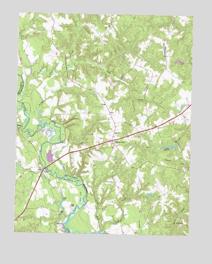
Aylett, VA USGS Topographic Map
Click on map above to begin viewing in our Map Viewer.

This topographic map contains these locations and features:
Feature Name Type Latitude Longitude GNIS ID View Map
AylettPopulated PlaceN37.7860°W77.1050°1477903View Map
Aylett CreekStreamN37.7563°W77.0883°1462633View Map
Aylett MillPopulated PlaceN37.7621°W77.0925°1477088View Map
Aylett Mill DamDamN37.7640°W77.0894°1490214View Map
Aylett PondReservoirN37.7671°W77.0916°1490215View Map
Aylett Post OfficePost OfficeN37.7629°W77.1164°2519590View Map
Beaver BranchStreamN37.8426°W77.0986°1462922View Map
BiscoePopulated PlaceN37.8179°W77.0577°1477116View Map
Buckyard BranchStreamN37.8107°W77.1091°1464023View Map
Cabin Landing PointLocaleN37.7599°W77.0866°1480271View Map
Cape CharliePopulated PlaceN37.7846°W77.0958°1480270View Map
Chapel CreekStreamN37.8243°W77.1225°1502781View Map
Deckers DamDamN37.7868°W77.1197°1490218View Map
Dixon CreekStreamN37.7665°W77.0755°1465836View Map
DunkirkLocaleN37.8135°W77.0991°1480212View Map
Fleets MillpondReservoirN37.8003°W77.0141°1466690View Map
Georges SwampStreamN37.7510°W77.0625°1467046View Map
Gwathmeys DamDamN37.7718°W77.0297°1490178View Map
Herring CreekStreamN37.8085°W77.1205°1467957View Map
Hope Alive Family ChurchChurchN37.7802°W77.1093°2520373View Map
Jones LandingLocaleN37.7793°W77.0797°1493149View Map
King William Volunteer Fire and RescueBuildingN37.7799°W77.1061°2331682View Map
Lawson Marriott Elementary SchoolSchoolN37.8240°W77.0620°1470103View Map
Lawson SchoolSchoolN37.8235°W77.0619°1469216View Map
London SwampStreamN37.7504°W77.0608°1469740View Map
Mikes BranchStreamN37.7813°W77.0847°1470446View Map
Millers DamDamN37.8485°W77.0080°1489643View Map
Millers PondReservoirN37.8485°W77.0085°1489644View Map
New Morning Star ChurchChurchN37.7790°W77.0544°1471475View Map
New Mount Zion ChurchChurchN37.7565°W77.0036°1471480View Map
Old Hall LandingLocaleN37.8018°W77.0922°1493372View Map
Pamunkey Regional Library King and Queen Branch LibraryBuildingN37.8078°W77.0541°2519921View Map
Pointers LandingPopulated PlaceN37.7513°W77.0877°1477635View Map
Poplar LandingPopulated PlaceN37.7649°W77.0822°1493448View Map
Providence Forge Volunteer Fire and RescueBuildingN37.7761°W77.0669°2086131View Map
Robinson BarBarN37.7521°W77.0872°1480272View Map
RosespoutPopulated PlaceN37.7557°W77.0905°1493505View Map
Saint Davids ChurchChurchN37.7849°W77.1036°1473713View Map
Saint Stephens ChurchLocaleN37.8026°W77.0555°1473919View Map
Saint Stephens Church DistrictCivilN37.8004°W77.0330°1927515View Map
Saint Stephens Church Post OfficePost OfficeN37.8038°W77.0569°2766495View Map
Shepherds ChurchChurchN37.8107°W77.0236°1474485View Map
Stolfi DamDamN37.8035°W77.0097°1490165View Map
Stolfi PondReservoirN37.8003°W77.0141°1490166View Map
Toddsbury Farm AirportAirportN37.8193°W77.1110°1498587View Map
Walker BarBarN37.7754°W77.0750°1480269View Map

Note: Coordinates in the location and feature list above are referenced to NAD83 datum.


Copyright (C) 2008-2024 Ryan Niemi / Sunset Dynamics ... All Rights Reserved