TopoQuest Logo
Do you find TopoQuest useful?
Help keep TopoQuest running and adding new maps/features by donating!
Bitcoin:  19c7KJd3qBynnjoSw5npx9KScwjBe4ifkT
Litecoin:  LXs6TkuXGGXo1vDsWCkWVdjQX94eUKd6ui
Home View Maps Find Maps Find Places Resources & Links


Banks, Mississippi Topographic Map

USGS Map Title: Banks, MS
USGS Map MRC: 34090G2
DRG (GeoTIFF) Download: o34090g2.tif


Neighboring USGS Topographic Map Quads:


  Horseshoe Lake, AR  
34090H3
 

  Lake Cormorant, MS  
34090H2
 

  Horn Lake, MS  
34090H1
 

  Robinsonville, MS  
34090G3
 

  Banks, MS  
34090G2
 

  Frees Corners, MS  
34090G1
 

  Hollywood, MS  
34090F3
 

  Arkabutla West, MS  
34090F2
 

  Arkabutla East, MS  
34090F1


Map MRC Location:

N35°
W91°
N35°
W90°
H8 H7 H6 H5 H4 H3 H2 H1
G8 G7 G6 G5 G4 G3 G2 G1
F8 F7 F6 F5 F4 F3 F2 F1
E8 E7 E6 E5 E4 E3 E2 E1
D8 D7 D6 D5 D4 D3 D2 D1
C8 C7 C6 C5 C4 C3 C2 C1
B8 B7 B6 B5 B4 B3 B2 B1
A8 A7 A6 A5 A4 A3 A2 A1
N34°
W91°
N34°
W90°

Banks, MS USGS 1:24K Topographic Map Preview:
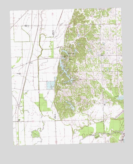
Banks, MS USGS Topographic Map
Click on map above to begin viewing in our Map Viewer.

This topographic map contains these locations and features:
Feature Name Type Latitude Longitude GNIS ID View Map
BanksPopulated PlaceN34.8259°W90.2298°666503View Map
Battle Ewing Catfish Ponds DamDamN34.8018°W90.2184°682801View Map
Beaverdam BayouStreamN34.7768°W90.2173°666724View Map
Beaverdam LakeLakeN34.8162°W90.2407°666734View Map
Bennetts Landing (historical)LocaleN34.8173°W90.2034°684829View Map
Big Six DitchCanalN34.8076°W90.2195°684830View Map
Bullards Chapel Christian Methodist Episcopal ChurchChurchN34.8598°W90.1309°690965View Map
Bullock SchoolSchoolN34.8593°W90.1320°690232View Map
Camp CurrierLocaleN34.8348°W90.1673°690237View Map
Chickasaw Council Boy Scout Lake DamDamN34.8434°W90.1751°690447View Map
Chief Chisca LakeReservoirN34.8299°W90.1912°690481View Map
Chief Chisca Lake DamDamN34.7984°W90.2018°690431View Map
Cub LakePopulated PlaceN34.7865°W90.1493°690260View Map
Delta Crest Subdivision Lake DamDamN34.8284°W90.1951°690438View Map
Duck Pond BayouStreamN34.8529°W90.2157°690271View Map
EudoraPopulated PlaceN34.8304°W90.1493°690277View Map
Eudora Baptist ChurchChurchN34.8315°W90.1495°690494View Map
Eudora Presbyterian ChurchChurchN34.8350°W90.1486°2511888View Map
Eudora Volunteer Fire DepartmentBuildingN34.8307°W90.1530°2665674View Map
Good Hope ChurchChurchN34.8290°W90.1932°690286View Map
Green RiverPopulated PlaceN34.7723°W90.2432°684847View Map
Harry Madision Pond DamDamN34.8401°W90.1784°690444View Map
Hugh Dancy Lake DamDamN34.7834°W90.1801°690427View Map
J A Earnheart Pond DamDamN34.8368°W90.1401°690441View Map
Koko Reef LakeReservoirN34.7855°W90.1845°690528View Map
Lake Greenwood LefloreReservoirN34.8351°W90.1883°690511View Map
Lake MussacumaReservoirN34.8282°W90.1861°690554View Map
Lake O' the HillsReservoirN34.8084°W90.1847°690563View Map
Lake O' the Hills DamDamN34.8068°W90.1901°690435View Map
Lakeside ChurchChurchN34.8707°W90.2193°690323View Map
Lost LakePopulated PlaceN34.7837°W90.2440°692022View Map
MarienettePopulated PlaceN34.8720°W90.2182°692041View Map
Neeley ChapelChurchN34.8290°W90.2190°674542View Map
Outlet Channel Public Use AreaParkN34.7595°W90.1312°683458View Map
Pleasant Grove ChurchChurchN34.7945°W90.1470°690576View Map
Pleasant Grove SchoolSchoolN34.7951°W90.1470°690379View Map
Pratt BridgeBridgeN34.7565°W90.1440°676316View Map
R O Dees Pond DamDamN34.8418°W90.1601°690446View Map
Saint Lukes ChurchChurchN34.8220°W90.2434°677118View Map
Sam CreekStreamN34.7665°W90.1651°690395View Map
TrinityPopulated PlaceN34.8093°W90.1754°690401View Map
Trinity ChurchChurchN34.8073°W90.1784°690601View Map
Union Hill ChurchChurchN34.7804°W90.1862°690402View Map
W T Hendricks Pond DamDamN34.8401°W90.1818°690445View Map
Whites CreekStreamN34.8382°W90.2140°690408View Map
Wilson StoreLocaleN34.8732°W90.1443°690411View Map
Woodland LakeReservoirN34.8183°W90.1902°690605View Map
Woodland Lake DamDamN34.8234°W90.1918°690437View Map

Note: Coordinates in the location and feature list above are referenced to NAD83 datum.


Copyright (C) 2008-2024 Ryan Niemi / Sunset Dynamics ... All Rights Reserved