TopoQuest Logo
Do you find TopoQuest useful?
Help keep TopoQuest running and adding new maps/features by donating!
Bitcoin:  19c7KJd3qBynnjoSw5npx9KScwjBe4ifkT
Litecoin:  LXs6TkuXGGXo1vDsWCkWVdjQX94eUKd6ui
Home View Maps Find Maps Find Places Resources & Links


Karnes City, Texas Topographic Map

USGS Map Title: Karnes City, TX
USGS Map MRC: 28097H8
DRG (GeoTIFF) Download: o28097h8.tif


Neighboring USGS Topographic Map Quads:


  Poth, TX  
29098A1
 

  Kosciusko, TX  
29097A8
 

  Ecleto, TX  
29097A7
 

  Falls City, TX  
28098H1
 

  Karnes City, TX  
28097H8
 

  Helena, TX  
28097H7
 

  Coy City, TX  
28098G1
 

  Lenz, TX  
28097G8
 

  Kenedy, TX  
28097G7


Map MRC Location:

N29°
W98°
N29°
W97°
H8 H7 H6 H5 H4 H3 H2 H1
G8 G7 G6 G5 G4 G3 G2 G1
F8 F7 F6 F5 F4 F3 F2 F1
E8 E7 E6 E5 E4 E3 E2 E1
D8 D7 D6 D5 D4 D3 D2 D1
C8 C7 C6 C5 C4 C3 C2 C1
B8 B7 B6 B5 B4 B3 B2 B1
A8 A7 A6 A5 A4 A3 A2 A1
N28°
W98°
N28°
W97°

Karnes City, TX USGS 1:24K Topographic Map Preview:
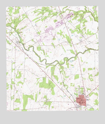
Karnes City, TX USGS Topographic Map
Click on map above to begin viewing in our Map Viewer.

This topographic map contains these locations and features:
Feature Name Type Latitude Longitude GNIS ID View Map
City of Karnes CityCivilN28.8858°W97.9002°2410165View Map
Cow CreekStreamN28.9289°W97.9342°1355196View Map
First Baptist ChurchChurchN28.8847°W97.8975°2022656View Map
First Presbyterian ChurchChurchN28.8875°W97.8975°2022664View Map
Highland ParkParkN28.8991°W97.8989°2029218View Map
HobsonPopulated PlaceN28.9575°W97.9853°1359323View Map
Hobson Post OfficePost OfficeN28.9550°W97.9871°2731418View Map
Horseshoe LakeLakeN28.9335°W97.9125°1359642View Map
Jacobs CreekStreamN28.9936°W97.9208°1360126View Map
Karnes CityPopulated PlaceN28.8850°W97.9008°1360493View Map
Karnes City City HallBuildingN28.8846°W97.8982°2753283View Map
Karnes City High SchoolSchoolN28.8866°W97.8933°2007076View Map
Karnes City Junior High SchoolSchoolN28.8866°W97.8933°2007077View Map
Karnes City Police DepartmentBuildingN28.8846°W97.8983°2739289View Map
Karnes City Post OfficePost OfficeN28.8826°W97.8978°2731607View Map
Karnes City RefineryLocaleN28.9064°W97.9250°1384586View Map
Karnes City Volunteer Fire DepartmentBuildingN28.8846°W97.8984°2552224View Map
Karnes County CourthouseBuildingN28.8850°W97.9011°2030649View Map
Karnes County JailBuildingN28.8835°W97.9118°2738880View Map
Karnes County Sheriff's DepartmentBuildingN28.8856°W97.9014°2739379View Map
Karnes County Sheriff's Office and JailBuildingN28.8856°W97.9014°2738771View Map
Lake SloughStreamN28.9408°W97.9053°1360855View Map
MayoPopulated PlaceN28.9053°W97.9225°1362337View Map
Mulifest CreekStreamN28.9933°W97.8908°1363462View Map
Panna MariaPopulated PlaceN28.9583°W97.8975°1364749View Map
Panna Maria Historic DistrictLocaleN28.9619°W97.8867°2031959View Map
Panna Maria Post OfficePost OfficeN28.9575°W97.8990°2732088View Map
Roger E Sides Elementary SchoolSchoolN28.8861°W97.8981°2007028View Map
Saint Cornelius Catholic ChurchChurchN28.8847°W97.8956°2022658View Map
Saint Mary CemeteryCemeteryN28.9644°W97.9050°1367246View Map
Saint Pauls Lutheran ChurchChurchN28.8819°W97.9033°2022662View Map
Turkey CreekStreamN28.9319°W97.9289°1370219View Map

Note: Coordinates in the location and feature list above are referenced to NAD83 datum.


Copyright (C) 2008-2024 Ryan Niemi / Sunset Dynamics ... All Rights Reserved