TopoQuest Logo
Do you find TopoQuest useful?
Help keep TopoQuest running and adding new maps/features by donating!
Bitcoin:  19c7KJd3qBynnjoSw5npx9KScwjBe4ifkT
Litecoin:  LXs6TkuXGGXo1vDsWCkWVdjQX94eUKd6ui
Home View Maps Find Maps Find Places Resources & Links


Kenedy, Texas Topographic Map

USGS Map Title: Kenedy, TX
USGS Map MRC: 28097G7
DRG (GeoTIFF) Download: o28097g7.tif


Neighboring USGS Topographic Map Quads:


  Karnes City, TX  
28097H8
 

  Helena, TX  
28097H7
 

  Runge, TX  
28097H6
 

  Lenz, TX  
28097G8
 

  Kenedy, TX  
28097G7
 

  Choate, TX  
28097G6
 

  Monteola, TX  
28097F8
 

  Tulsita, TX  
28097F7
 

  Berclair NW, TX  
28097F6


Map MRC Location:

N29°
W98°
N29°
W97°
H8 H7 H6 H5 H4 H3 H2 H1
G8 G7 G6 G5 G4 G3 G2 G1
F8 F7 F6 F5 F4 F3 F2 F1
E8 E7 E6 E5 E4 E3 E2 E1
D8 D7 D6 D5 D4 D3 D2 D1
C8 C7 C6 C5 C4 C3 C2 C1
B8 B7 B6 B5 B4 B3 B2 B1
A8 A7 A6 A5 A4 A3 A2 A1
N28°
W98°
N28°
W97°

Kenedy, TX USGS 1:24K Topographic Map Preview:
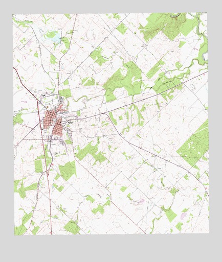
Kenedy, TX USGS Topographic Map
Click on map above to begin viewing in our Map Viewer.

This topographic map contains these locations and features:
Feature Name Type Latitude Longitude GNIS ID View Map
Ball ParkParkN28.8119°W97.8503°2028808View Map
Butler CemeteryCemeteryN28.8303°W97.8508°1353420View Map
Card AirfieldAirportN28.7875°W97.7637°2675832View Map
Carr HollowValleyN28.7741°W97.7717°1353855View Map
City of KenedyCivilN28.8175°W97.8518°2410180View Map
Community Bible ChurchChurchN28.8125°W97.8567°2022665View Map
Cow HollowValleyN28.8284°W97.8173°1355208View Map
Dam Number 11DamN28.8614°W97.8436°1355567View Map
Dry Escondido CreekStreamN28.8344°W97.8039°1356347View Map
Escondido CemeteryCemeteryN28.8530°W97.8094°1357054View Map
First Mexican Baptist ChurchChurchN28.8208°W97.8503°2022657View Map
Good Shephard Lutheran ChurchChurchN28.8091°W97.8556°2022661View Map
Hondo Creek Oil FieldOilfieldN28.7783°W97.7842°1359490View Map
Karnes County AcademySchoolN28.8194°W97.8489°2007079View Map
Karnes County AirportAirportN28.8269°W97.8652°1387002View Map
Karnes County Emergency Medical Service AmbulanceBuildingN28.8167°W97.8547°2656157View Map
KenedyPopulated PlaceN28.8191°W97.8486°1360572View Map
Kenedy CemeteryCemeteryN28.8253°W97.8281°1360573View Map
Kenedy Church of ChristChurchN28.8169°W97.8547°2022659View Map
Kenedy DivisionCivilN28.7696°W97.8353°1938880View Map
Kenedy Elementary SchoolSchoolN28.8294°W97.8500°2007080View Map
Kenedy Fire DeptBuildingN28.8179°W97.8500°2552207View Map
Kenedy High SchoolSchoolN28.8294°W97.8500°2007081View Map
Kenedy Middle SchoolSchoolN28.8294°W97.8500°2007027View Map
Kenedy Municipal BuildingBuildingN28.8181°W97.8504°2753946View Map
Kenedy MuseumBuildingN28.7694°W97.8353°2014588View Map
Kenedy Police DepartmentBuildingN28.8185°W97.8498°2739261View Map
Kenedy Post OfficePost OfficeN28.8174°W97.8482°2731609View Map
Kennedy CemeteryCemeteryN28.8094°W97.8333°1360576View Map
KTNR-FM (Kenedy)TowerN28.7600°W97.8628°1385896View Map
Nichols CreekStreamN28.8241°W97.8419°1363874View Map
Panther CreekStreamN28.8200°W97.8711°1364776View Map
Possum HollowValleyN28.7702°W97.8134°1365625View Map
Rialto Theater (historical)BuildingN28.8187°W97.8506°2729344View Map
Rock HollowValleyN28.7642°W97.7792°1366668View Map
Saint Matthews Episcopal ChurchChurchN28.8158°W97.8514°2022660View Map
Soil Conservation Service Site 11 DamDamN28.8620°W97.8441°1858249View Map
Soil Conservation Service Site 11 ReservoirReservoirN28.8610°W97.8459°1858250View Map
Soil Conservation Service Site 2 DamDamN28.7686°W97.7919°1858247View Map
Soil Conservation Service Site 2 ReservoirReservoirN28.7684°W97.7931°1858248View Map
Soil Conservation Service Site 3 DamDamN28.7653°W97.7636°1858245View Map
Soil Conservation Service Site 3 ReservoirReservoirN28.7653°W97.7636°1858246View Map
Texas Department of Criminal Justice John B Connally UnitBuildingN28.7752°W97.8345°2738587View Map
Unified Pentecostal ChurchChurchN28.8100°W97.8433°2022663View Map

Note: Coordinates in the location and feature list above are referenced to NAD83 datum.


Copyright (C) 2008-2024 Ryan Niemi / Sunset Dynamics ... All Rights Reserved