TopoQuest Logo
Do you find TopoQuest useful?
Help keep TopoQuest running and adding new maps/features by donating!
Bitcoin:  19c7KJd3qBynnjoSw5npx9KScwjBe4ifkT
Litecoin:  LXs6TkuXGGXo1vDsWCkWVdjQX94eUKd6ui
Home View Maps Find Maps Find Places Resources & Links


Kanab, Utah Topographic Map

USGS Map Title: Kanab, UT
USGS Map MRC: 37112A5
DRG (GeoTIFF) Download: o37112a5.tif


Neighboring USGS Topographic Map Quads:


  Mount Carmel, UT  
37112B6
 

  White Tower, UT  
37112B5
 

  Cutler Point, UT  
37112B4
 

  Yellowjacket Canyon, UT  
37112A6
 

  Kanab, UT  
37112A5
 

  Thompson Point, UT  
37112A4
 

  Kaibab, AZ  
36112H6
 

  Fredonia, AZ  
36112H5
 

  Shinarump Point, AZ  
36112H4


Map MRC Location:

N38°
W113°
N38°
W112°
H8 H7 H6 H5 H4 H3 H2 H1
G8 G7 G6 G5 G4 G3 G2 G1
F8 F7 F6 F5 F4 F3 F2 F1
E8 E7 E6 E5 E4 E3 E2 E1
D8 D7 D6 D5 D4 D3 D2 D1
C8 C7 C6 C5 C4 C3 C2 C1
B8 B7 B6 B5 B4 B3 B2 B1
A8 A7 A6 A5 A4 A3 A2 A1
N37°
W113°
N37°
W112°

Kanab, UT USGS 1:24K Topographic Map Preview:
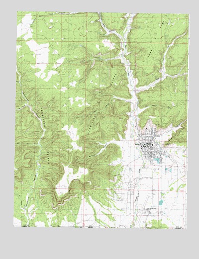
Kanab, UT USGS Topographic Map
Click on map above to begin viewing in our Map Viewer.

This topographic map contains these locations and features:
Feature Name Type Latitude Longitude GNIS ID View Map
Art CanyonValleyN37.0094°W112.6171°1435069View Map
Bunting CanyonValleyN37.0455°W112.5460°1426161View Map
Cave Lakes CanyonValleyN37.1250°W112.5705°1426424View Map
City of KanabCivilN37.0269°W112.5048°2410164View Map
Cottonwood CanyonValleyN37.0125°W112.6174°1426894View Map
Cottonwood PointSummitN37.0250°W112.6202°1435354View Map
Crazy Horse CamparkLocaleN37.0358°W112.5021°1448311View Map
Dinosaur TracksLocaleN37.0767°W112.5299°1435429View Map
Dry CanyonValleyN37.0675°W112.5344°1427507View Map
Dry SpringSpringN37.0707°W112.5150°1427583View Map
Farm CanyonValleyN37.0830°W112.6222°1427882View Map
First Baptist ChurchChurchN37.0417°W112.5241°1436714View Map
Hog CanyonValleyN37.0803°W112.5380°1428740View Map
Indian CanyonValleyN37.0700°W112.6169°1428985View Map
Indian Dance HallSummitN37.0489°W112.5149°1428996View Map
KanabPopulated PlaceN37.0475°W112.5263°1429276View Map
Kanab City CemeteryCemeteryN37.0441°W112.5185°1435800View Map
Kanab City Police DepartmentBuildingN37.0462°W112.5254°2730409View Map
Kanab Elementary SchoolSchoolN37.0495°W112.5295°1455078View Map
Kanab Fire DepartmentBuildingN37.0386°W112.5250°2627200View Map
Kanab Fire Department Ranchos Fire HouseBuildingN37.0249°W112.5425°2627248View Map
Kanab High SchoolSchoolN37.0387°W112.5280°1435801View Map
Kanab Municipal AirportAirportN37.0111°W112.5312°1434534View Map
Kanab Pioneer Park CemeteryCemeteryN37.0550°W112.5251°2769372View Map
Kanab Post OfficePost OfficeN37.0475°W112.5281°1455350View Map
Kane County AmbulanceBuildingN37.0386°W112.5250°2665452View Map
Kane County Ambulance KanabBuildingN37.0544°W112.5297°2768460View Map
Kane County HospitalHospitalN37.0544°W112.5292°1435805View Map
Kane County Sheriffs OfficeBuildingN37.0018°W112.5083°2730369View Map
Littles Campground and RV ParkParkN37.0428°W112.5246°1435882View Map
North Fork Hog CanyonValleyN37.0878°W112.5180°1430790View Map
Old Movie FortLocaleN37.0028°W112.5794°1436068View Map
Pugh CanyonValleyN37.0400°W112.5066°1431493View Map
Saint Christopher Catholic ChurchChurchN37.0442°W112.5291°1436762View Map
Savage PointCapeN37.0544°W112.5041°1432248View Map
Spencer Number Two DamDamN37.0133°W112.5208°1434604View Map
Spencer Number Two ReservoirReservoirN37.0155°W112.5186°1434603View Map
The Church of Jesus Christ of Latter Day SaintsChurchN37.0389°W112.5258°1450777View Map
The Church of Jesus Christ of Latter Day SaintsChurchN37.0483°W112.5291°1450778View Map
Three Lakes CanyonValleyN37.1097°W112.5469°1433491View Map
Tiny CanyonValleyN37.0989°W112.5494°1433554View Map
Toms CanyonValleyN37.0500°W112.5219°1433582View Map
Trail CanyonValleyN37.0730°W112.5416°1433618View Map
Utah Highway Patrol Section 9 Kanab OfficeBuildingN37.0461°W112.5259°2730506View Map

Note: Coordinates in the location and feature list above are referenced to NAD83 datum.


Copyright (C) 2008-2024 Ryan Niemi / Sunset Dynamics ... All Rights Reserved