TopoQuest Logo
Do you find TopoQuest useful?
Help keep TopoQuest running and adding new maps/features by donating!
Bitcoin:  19c7KJd3qBynnjoSw5npx9KScwjBe4ifkT
Litecoin:  LXs6TkuXGGXo1vDsWCkWVdjQX94eUKd6ui
Home View Maps Find Maps Find Places Resources & Links


Ibex Peak, Idaho Topographic Map

USGS Map Title: Ibex Peak, ID
USGS Map MRC: 42114A1
DRG (GeoTIFF) Download: o42114a1.tif


Neighboring USGS Topographic Map Quads:


  Trapper Peak, ID  
42114B2
 

  Severe Spring, ID  
42114B1
 

  Oakley, ID  
42113B8
 

  Mahogany Butte, ID  
42114A2
 

  Ibex Peak, ID  
42114A1
 

  Blue Hill, ID  
42113A8
 

  Fivemile Gulch, NV  
41114H2
 

  Nile Spring, NV  
41114H1
 

  Pole Creek, UT  
41113H8


Map MRC Location:

N43°
W115°
N43°
W114°
H8 H7 H6 H5 H4 H3 H2 H1
G8 G7 G6 G5 G4 G3 G2 G1
F8 F7 F6 F5 F4 F3 F2 F1
E8 E7 E6 E5 E4 E3 E2 E1
D8 D7 D6 D5 D4 D3 D2 D1
C8 C7 C6 C5 C4 C3 C2 C1
B8 B7 B6 B5 B4 B3 B2 B1
A8 A7 A6 A5 A4 A3 A2 A1
N42°
W115°
N42°
W114°

Ibex Peak, ID USGS 1:24K Topographic Map Preview:
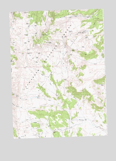
Ibex Peak, ID USGS Topographic Map
Click on map above to begin viewing in our Map Viewer.

This topographic map contains these locations and features:
Feature Name Type Latitude Longitude GNIS ID View Map
Beaverdam CreekStreamN42.0044°W114.0006°376437View Map
Beaverdam PassGapN42.0874°W114.1036°377292View Map
Beaverdam Pass SpringSpringN42.0837°W114.1033°377293View Map
Carlson CanyonValleyN42.0310°W114.1131°378938View Map
Carlson CreekStreamN42.0324°W114.0678°378940View Map
Chalk SpringSpringN42.0987°W114.0537°379155View Map
Daves PassGapN42.0816°W114.0447°380264View Map
Daves Pass SpringSpringN42.0851°W114.0433°380265View Map
Dry GulchValleyN42.0169°W114.0272°380857View Map
Dry Gulch SpringSpringN42.0566°W114.0520°380880View Map
Emery RanchLocaleN42.0163°W114.0289°381458View Map
Frish RanchLocaleN42.0413°W114.0889°382089View Map
Hole in the Wall SpringSpringN42.0933°W114.0707°383252View Map
Ibex PeakSummitN42.1013°W114.0811°384494View Map
Johnnys CanyonValleyN42.0402°W114.1017°383964View Map
Left Hand Fork Beaverdam CreekStreamN42.0321°W114.0653°384549View Map
Lone Cedar SpringSpringN42.1173°W114.0218°385991View Map
Lone Pine SpringSpringN42.1017°W114.1018°386012View Map
Mabey SpringSpringN42.1135°W114.1031°386317View Map
Mabey Spring Number 2SpringN42.1237°W114.1057°386318View Map
Magpie SpringSpringN42.0979°W114.0240°386363View Map
N E CanyonValleyN42.0063°W114.0711°387450View Map
N E CreekStreamN42.0096°W114.0147°387451View Map
N W SpringSpringN42.0160°W114.0972°387454View Map
Orangeburg SpringSpringN42.0055°W114.0724°387981View Map
Owens Corral SpringSpringN42.1027°W114.0299°388047View Map
Point SpringSpringN42.0015°W114.1185°388629View Map
Right Hand Fork Beaverdam CreekStreamN42.0321°W114.0653°389381View Map
Rock SpringSpringN42.0807°W114.0266°389525View Map
Rodeo SpringSpringN42.1106°W114.0895°389574View Map
Sage Hen SpringSpringN42.1037°W114.0463°389805View Map
Section 9 SpringSpringN42.0507°W114.0032°390090View Map
Sheep SpringSpringN42.0937°W114.1034°390255View Map
Swede SpringSpringN42.0832°W114.0856°391763View Map
Tent SpringSpringN42.0747°W114.0923°391930View Map
Triple SpringSpringN42.0791°W114.0917°392399View Map
Twin SpringsSpringN42.0882°W114.0297°392544View Map
Wards CorralLocaleN42.0952°W114.1020°392837View Map
Worthington MineMineN42.0113°W114.0784°393702View Map

Note: Coordinates in the location and feature list above are referenced to NAD83 datum.


Copyright (C) 2008-2024 Ryan Niemi / Sunset Dynamics ... All Rights Reserved