TopoQuest Logo
Do you find TopoQuest useful?
Help keep TopoQuest running and adding new maps/features by donating!
Bitcoin:  19c7KJd3qBynnjoSw5npx9KScwjBe4ifkT
Litecoin:  LXs6TkuXGGXo1vDsWCkWVdjQX94eUKd6ui
Home View Maps Find Maps Find Places Resources & Links


Hayward, Wisconsin Topographic Map

USGS Map Title: Hayward, WI
USGS Map MRC: 46091A4
DRG (GeoTIFF) Download: o46091a4.tif


Neighboring USGS Topographic Map Quads:


  Chittamo NE, WI  
46091B5
 

  Totagatic Lake, WI  
46091B4
 

  Cable, WI  
46091B3
 

  Stanberry East, WI  
46091A5
 

  Hayward, WI  
46091A4
 

  Seeley, WI  
46091A3
 

  Bean Lake, WI  
45091H5
 

  Reserve, WI  
45091H4
 

  Chief Lake, WI  
45091H3


Map MRC Location:

N47°
W92°
N47°
W91°
H8 H7 H6 H5 H4 H3 H2 H1
G8 G7 G6 G5 G4 G3 G2 G1
F8 F7 F6 F5 F4 F3 F2 F1
E8 E7 E6 E5 E4 E3 E2 E1
D8 D7 D6 D5 D4 D3 D2 D1
C8 C7 C6 C5 C4 C3 C2 C1
B8 B7 B6 B5 B4 B3 B2 B1
A8 A7 A6 A5 A4 A3 A2 A1
N46°
W92°
N46°
W91°

Hayward, WI USGS 1:24K Topographic Map Preview:
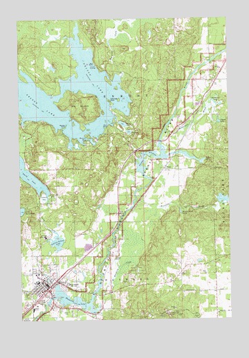
Hayward, WI USGS Topographic Map
Click on map above to begin viewing in our Map Viewer.

This topographic map contains these locations and features:
Feature Name Type Latitude Longitude GNIS ID View Map
Ascension Episcopal ChurchChurchN46.0166°W91.4827°1833734View Map
Beaver BayBayN46.0750°W91.4630°1561420View Map
Big IslandIslandN46.0888°W91.4641°1561739View Map
Blair School (historical)SchoolN46.0925°W91.3955°1833740View Map
Bradley BranchStreamN46.0063°W91.4857°1562128View Map
Bullhead LakeLakeN46.0780°W91.4348°1562404View Map
City of HaywardCivilN46.0094°W91.4826°1583370View Map
Community Bible ChurchChurchN46.0055°W91.4796°1833747View Map
Eytcheson ParkParkN46.0522°W91.4818°1564790View Map
First Congregational ChurchChurchN46.0161°W91.4868°1833752View Map
First Lutheran ChurchChurchN46.0191°W91.4896°1833753View Map
Hatchery CreekStreamN46.0113°W91.4541°1566127View Map
HaywardPopulated PlaceN46.0130°W91.4846°1566225View Map
Hayward Area Memorial HospitalHospitalN46.0349°W91.4858°1566227View Map
Hayward Carnegie LibraryBuildingN46.0141°W91.4835°1833755View Map
Hayward Center for Individualized LearningSchoolN46.0156°W91.4900°2713176View Map
Hayward City Fire DepartmentBuildingN46.0142°W91.4867°2696946View Map
Hayward City HallBuildingN46.0141°W91.4835°1833756View Map
Hayward Fire TowerTowerN46.0022°W91.4074°1833758View Map
Hayward Flowage 94ReservoirN46.0066°W91.4835°1793065View Map
Hayward Golf and Tennis ClubLocaleN46.0191°W91.4938°1833759View Map
Hayward Hydro Generating StationLocaleN46.0066°W91.4841°2742087View Map
Hayward Intermediate SchoolSchoolN46.0156°W91.4898°2713311View Map
Hayward LakeReservoirN46.0081°W91.4698°1566226View Map
Hayward Police DepartmentBuildingN46.0138°W91.4872°2759618View Map
Hayward Post OfficePost OfficeN46.0155°W91.4863°1833761View Map
Hayward Primary SchoolSchoolN46.0180°W91.4902°1833757View Map
Hayward Town Police DepartmentBuildingN46.0128°W91.4650°2759886View Map
Hayward Township Fire DepartmentBuildingN46.0128°W91.4650°2696871View Map
Hayward Wesleyan Methodist ChurchChurchN46.0144°W91.4907°1833762View Map
Hayward WP119 DamDamN46.0066°W91.4841°1793064View Map
Indian CemeteryCemeteryN46.0032°W91.4726°1833765View Map
Indian School (historical)SchoolN46.0361°W91.4824°1833767View Map
Indian School LakeLakeN46.0326°W91.4784°1566932View Map
Lenroot LandingLocaleN46.1063°W91.4552°1577698View Map
Little Round LakeLakeN46.0454°W91.4995°1568397View Map
McDermott BrookStreamN46.0741°W91.4152°1569193View Map
Milny LakeLakeN46.0814°W91.4383°1569531View Map
Mosquito BrookStreamN46.0486°W91.4318°1569775View Map
Mosquito Brook SpringSpringN46.0446°W91.4045°1569776View Map
National Fresh Water Fishing Hall of FameBuildingN46.0077°W91.4793°1833778View Map
Nelson LakeReservoirN46.0788°W91.4734°1570165View Map
Northern Lights Christian AcademySchoolN46.0055°W91.4796°2713347View Map
Norway PointCapeN46.0802°W91.4727°1570546View Map
O'Brien Hill School (historical)SchoolN46.0183°W91.4052°1833781View Map
Osgood LakeLakeN46.0819°W91.3808°1570873View Map
PhippsPopulated PlaceN46.0627°W91.4135°1571301View Map
Phipps FlowageReservoirN46.0680°W91.4255°1571302View Map
Phipps SpringSpringN46.0663°W91.3905°1571304View Map
Porcupine LakeLakeN46.0902°W91.3838°1571788View Map
Saint Josephs Catholic ChurchChurchN46.0158°W91.4874°1833795View Map
Sawyer County AirportAirportN46.0284°W91.4444°1582007View Map
Sawyer County CourthouseBuildingN46.0169°W91.4866°1833798View Map
Sawyer County Emergency Ambulance Service Hayward StationBuildingN46.0186°W91.4878°2698367View Map
Sawyer County JailBuildingN46.0172°W91.4873°2759845View Map
Sawyer County Sheriff's DepartmentBuildingN46.0172°W91.4873°2759844View Map
Seventh Day Adventist ChurchChurchN46.0133°W91.4913°1833799View Map
Shues PondLakeN46.0167°W91.4843°1833800View Map
Smith LakeLakeN46.0616°W91.4974°1574300View Map
Smith Lake CreekStreamN46.0150°W91.4791°1577311View Map
Smith Lake School (historical)SchoolN46.0625°W91.4777°1833801View Map
Tag-Alder CreekStreamN46.1011°W91.4382°1580574View Map
Tannings PointCapeN46.0911°W91.4460°1575256View Map
The Church of Jesus Christ of Latter Day SaintsChurchN46.0136°W91.4730°1833745View Map
Town of LenrootCivilN46.1029°W91.4339°1583542View Map
Trinity CemeteryCemeteryN46.0626°W91.4059°1575621View Map
Trinity Lutheran ChurchChurchN46.0147°W91.4760°1833807View Map
Turk SpringSpringN46.0436°W91.4396°1575722View Map
Wheeler School (historical)SchoolN46.0041°W91.4460°1833811View Map

Note: Coordinates in the location and feature list above are referenced to NAD83 datum.


Copyright (C) 2008-2024 Ryan Niemi / Sunset Dynamics ... All Rights Reserved