TopoQuest Logo
Do you find TopoQuest useful?
Help keep TopoQuest running and adding new maps/features by donating!
Bitcoin:  19c7KJd3qBynnjoSw5npx9KScwjBe4ifkT
Litecoin:  LXs6TkuXGGXo1vDsWCkWVdjQX94eUKd6ui
Home View Maps Find Maps Find Places Resources & Links


Halltown, Missouri Topographic Map

USGS Map Title: Halltown, MO
USGS Map MRC: 37093B6
DRG (GeoTIFF) Download: o37093b6.tif


Neighboring USGS Topographic Map Quads:


  South Greenfield, MO  
37093C7
 

  Everton, MO  
37093C6
 

  Ash Grove, MO  
37093C5
 

  Miller, MO  
37093B7
 

  Halltown, MO  
37093B6
 

  Halltown NE, MO  
37093B5
 

  Mount Vernon, MO  
37093A7
 

  Chesapeake, MO  
37093A6
 

  Billings, MO  
37093A5


Map MRC Location:

N38°
W94°
N38°
W93°
H8 H7 H6 H5 H4 H3 H2 H1
G8 G7 G6 G5 G4 G3 G2 G1
F8 F7 F6 F5 F4 F3 F2 F1
E8 E7 E6 E5 E4 E3 E2 E1
D8 D7 D6 D5 D4 D3 D2 D1
C8 C7 C6 C5 C4 C3 C2 C1
B8 B7 B6 B5 B4 B3 B2 B1
A8 A7 A6 A5 A4 A3 A2 A1
N37°
W94°
N37°
W93°

Halltown, MO USGS 1:24K Topographic Map Preview:
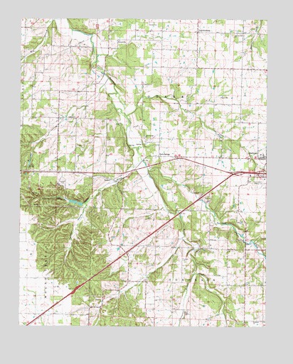
Halltown, MO USGS Topographic Map
Click on map above to begin viewing in our Map Viewer.

This topographic map contains these locations and features:
Feature Name Type Latitude Longitude GNIS ID View Map
Billies CreekStreamN37.2106°W93.6963°714236View Map
Carmen HollowValleyN37.1737°W93.7171°715406View Map
Chesapeake BranchStreamN37.1467°W93.6616°715771View Map
Concord School (historical)SchoolN37.1301°W93.7423°746394View Map
Cove SpringSpringN37.1770°W93.7316°716396View Map
Devils Wash PanCliffN37.1764°W93.7358°716867View Map
Dunkle CemeteryCemeteryN37.2475°W93.6855°717189View Map
East Elementary School (historical)SchoolN37.1952°W93.6283°2710336View Map
Goose CreekStreamN37.1884°W93.6852°718585View Map
HalltownPopulated PlaceN37.1934°W93.6255°758433View Map
Halltown Post OfficePost OfficeN37.1936°W93.6265°765606View Map
Halltown Volunteer Fire Department Station 1BuildingN37.1936°W93.6283°2621094View Map
Halltown Volunteer Fire Department Station 2BuildingN37.1639°W93.6845°2621313View Map
Johnson CreekStreamN37.1928°W93.6883°720366View Map
LawrenceburgPopulated PlaceN37.2445°W93.6602°729916View Map
Lawrenceburg School (historical)SchoolN37.2479°W93.6608°746395View Map
Mendenhall Lake DamDamN37.1751°W93.7219°763317View Map
Misemer CemeteryCemeteryN37.2070°W93.7016°722459View Map
Moore School (historical)SchoolN37.2420°W93.6974°746391View Map
Mount Comfort School (historical)SchoolN37.1510°W93.6861°746399View Map
New Hope ChurchChurchN37.1562°W93.6408°723245View Map
NickelvillePopulated PlaceN37.2401°W93.7008°741104View Map
Onward ChurchChurchN37.2098°W93.7258°723827View Map
Onward School (historical)SchoolN37.2095°W93.7213°746392View Map
Ozark Cavefish National Wildlife RefugeParkN37.1999°W93.6953°2765438View Map
Paris SpringsPopulated PlaceN37.1942°W93.6794°724009View Map
Paris Springs ChurchChurchN37.2020°W93.6866°724010View Map
Paris Springs School (historical)SchoolN37.2014°W93.6874°746397View Map
Parish SpringsSpringN37.1991°W93.6886°739498View Map
Pilgrims Rest ChurchChurchN37.2439°W93.6405°724343View Map
Pritchett CemeteryCemeteryN37.1523°W93.6674°724940View Map
Rock Prairie CemeteryCemeteryN37.1862°W93.6255°725467View Map
RoperLocaleN37.1564°W93.6405°740398View Map
Roper School (historical)SchoolN37.1569°W93.6365°746398View Map
SpencerPopulated PlaceN37.1845°W93.7024°741276View Map
Spencer School (historical)SchoolN37.1592°W93.7463°746393View Map
Sycamore ChurchChurchN37.1273°W93.6316°727406View Map
Sycamore School (historical)SchoolN37.1273°W93.6324°746400View Map
Township of OzarkCivilN37.2277°W93.6774°766886View Map
Union Hall School (historical)SchoolN37.2293°W93.6378°745908View Map
Village of HalltownCivilN37.1946°W93.6291°2398225View Map
Wann CemeteryCemeteryN37.2184°W93.6485°728336View Map

Note: Coordinates in the location and feature list above are referenced to NAD83 datum.


Copyright (C) 2008-2024 Ryan Niemi / Sunset Dynamics ... All Rights Reserved