TopoQuest Logo
Do you find TopoQuest useful?
Help keep TopoQuest running and adding new maps/features by donating!
Bitcoin:  19c7KJd3qBynnjoSw5npx9KScwjBe4ifkT
Litecoin:  LXs6TkuXGGXo1vDsWCkWVdjQX94eUKd6ui
Home View Maps Find Maps Find Places Resources & Links


Granby, Colorado Topographic Map

USGS Map Title: Granby, CO
USGS Map MRC: 40105A8
DRG (GeoTIFF) Download: o40105a8.tif


Neighboring USGS Topographic Map Quads:


  Cabin Creek, CO  
40106B1
 

  Trail Mountain, CO  
40105B8
 

  Shadow Mountain, CO  
40105B7
 

  Hot Sulphur Springs, CO  
40106A1
 

  Granby, CO  
40105A8
 

  Strawberry Lake, CO  
40105A7
 

  Sylvan Reservoir, CO  
39106H1
 

  Bottle Pass, CO  
39105H8
 

  Fraser, CO  
39105H7


Map MRC Location:

N41°
W106°
N41°
W105°
H8 H7 H6 H5 H4 H3 H2 H1
G8 G7 G6 G5 G4 G3 G2 G1
F8 F7 F6 F5 F4 F3 F2 F1
E8 E7 E6 E5 E4 E3 E2 E1
D8 D7 D6 D5 D4 D3 D2 D1
C8 C7 C6 C5 C4 C3 C2 C1
B8 B7 B6 B5 B4 B3 B2 B1
A8 A7 A6 A5 A4 A3 A2 A1
N40°
W106°
N40°
W105°

Granby, CO USGS 1:24K Topographic Map Preview:
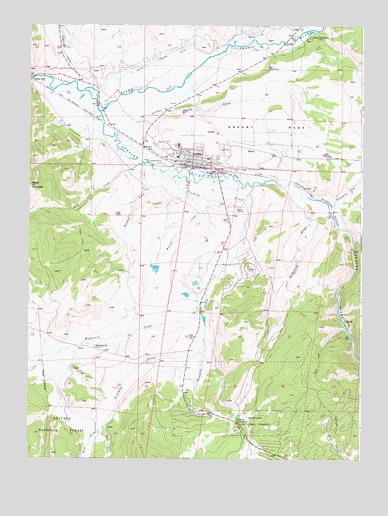
Granby, CO USGS Topographic Map
Click on map above to begin viewing in our Map Viewer.

This topographic map contains these locations and features:
Feature Name Type Latitude Longitude GNIS ID View Map
Behler CreekStreamN40.0630°W105.8786°178388View Map
Bunte Highline DitchCanalN40.1167°W105.9339°202533View Map
Central Assembly of God ChurchChurchN40.0880°W105.9458°2043317View Map
Church of ChristChurchN40.0930°W105.9386°2043320View Map
Coyote CreekStreamN40.1089°W105.9834°178082View Map
De Berard DrawValleyN40.0743°W105.8968°178394View Map
East Fork Ninemile CreekStreamN40.0092°W105.9717°178391View Map
East Grand Middle SchoolSchoolN40.0920°W105.9471°2043318View Map
Eightmile CreekStreamN40.0433°W105.9353°175728View Map
Eightmile SchoolLocaleN40.0319°W105.9747°178396View Map
ElkdalePopulated PlaceN40.0403°W105.8811°178397View Map
Elkdale Post Office (historical)Post OfficeN40.0403°W105.8811°2026929View Map
F W Linke Number 2 DamDamN40.0550°W105.9522°201462View Map
F W Linke Number 3 DamDamN40.0483°W105.9406°201464View Map
F W Linke Reservoir Number 2ReservoirN40.0549°W105.9526°201463View Map
F W Linke Reservoir Number 3ReservoirN40.0475°W105.9411°201465View Map
Flying Heels ArenaBuildingN40.0658°W105.9239°2043305View Map
Fraser RiverStreamN40.1003°W105.9742°178386View Map
GranbyPopulated PlaceN40.0861°W105.9395°178402View Map
Granby CemeteryCemeteryN40.0839°W105.8858°2087606View Map
Granby Elementary SchoolSchoolN40.0872°W105.9452°2043316View Map
Granby MesaSummitN40.0808°W105.8889°178401View Map
Granby Police DepartmentBuildingN40.0870°W105.9422°2757335View Map
Granby Post OfficePost OfficeN40.0863°W105.9418°2734610View Map
Granby Sports Park Airport (historical)AirportN40.0486°W105.9389°204423View Map
Granby-Grand County AirportAirportN40.0898°W105.9147°204422View Map
Grand County Emergency Medical Services Station 1BuildingN40.0862°W105.9435°2716975View Map
Grand Fire Protection District 1 Headquarters StationBuildingN40.0805°W105.9299°2667328View Map
Grand Fire Protection District 1 Red Dirt StationBuildingN40.0059°W105.9202°2667329View Map
KRKY-AM (Granby)TowerN40.0405°W105.9370°204018View Map
Linke DamDamN40.0517°W105.9372°201468View Map
Linke ReservoirReservoirN40.0508°W105.9376°201469View Map
Lord of the Valley Lutheran ChurchChurchN40.0614°W105.9295°2043315View Map
Middle Park High SchoolSchoolN40.0922°W105.9399°2043319View Map
Middle Park Medical Center - Granby CampusHospitalN40.0758°W105.9259°2695635View Map
Mount ChaunceySummitN40.0786°W105.9995°202140View Map
Muller CreekStreamN40.0750°W105.9403°178398View Map
Ninemile CreekStreamN40.0308°W105.9336°178393View Map
Peterson DitchCanalN40.1014°W105.9478°178404View Map
Reed CreekStreamN40.0864°W105.9625°178399View Map
Rockwell CreekStreamN40.0842°W105.9606°178400View Map
Silver Creek Ski AreaLocaleN40.0400°W105.9042°197897View Map
Smith CreekStreamN40.1005°W105.9720°178403View Map
Strawberry CreekStreamN40.0728°W105.8878°178387View Map
Sulphur District Ranger OfficeLocaleN40.0739°W105.9264°197898View Map
Tabernash CampgroundLocaleN40.0103°W105.9208°178395View Map
Tenmile CreekStreamN40.0836°W105.9528°178390View Map
Town of GranbyCivilN40.0185°W105.9117°2412699View Map
West Fork Ninemile CreekStreamN40.0092°W105.9717°178392View Map
Willow CreekStreamN40.1189°W105.9206°173044View Map
Windy Gap ReservoirReservoirN40.1049°W105.9806°197899View Map

Note: Coordinates in the location and feature list above are referenced to NAD83 datum.


Copyright (C) 2008-2024 Ryan Niemi / Sunset Dynamics ... All Rights Reserved