TopoQuest Logo
Do you find TopoQuest useful?
Help keep TopoQuest running and adding new maps/features by donating!
Bitcoin:  19c7KJd3qBynnjoSw5npx9KScwjBe4ifkT
Litecoin:  LXs6TkuXGGXo1vDsWCkWVdjQX94eUKd6ui
Home View Maps Find Maps Find Places Resources & Links


Grace, Idaho Topographic Map

USGS Map Title: Grace, ID
USGS Map MRC: 42111E6
DRG (GeoTIFF) Download: o42111e6.tif


Neighboring USGS Topographic Map Quads:


  Talmage, ID  
42111F7
 

  Alexander, ID  
42111F6
 

  Soda Springs, ID  
42111F5
 

  Grace Power Plant, ID  
42111E7
 

  Grace, ID  
42111E6
 

  Soda Peak, ID  
42111E5
 

  Thatcher Hill, ID  
42111D7
 

  Thatcher, ID  
42111D6
 

  North Canyon, ID  
42111D5


Map MRC Location:

N43°
W112°
N43°
W111°
H8 H7 H6 H5 H4 H3 H2 H1
G8 G7 G6 G5 G4 G3 G2 G1
F8 F7 F6 F5 F4 F3 F2 F1
E8 E7 E6 E5 E4 E3 E2 E1
D8 D7 D6 D5 D4 D3 D2 D1
C8 C7 C6 C5 C4 C3 C2 C1
B8 B7 B6 B5 B4 B3 B2 B1
A8 A7 A6 A5 A4 A3 A2 A1
N42°
W112°
N42°
W111°

Grace, ID USGS 1:24K Topographic Map Preview:
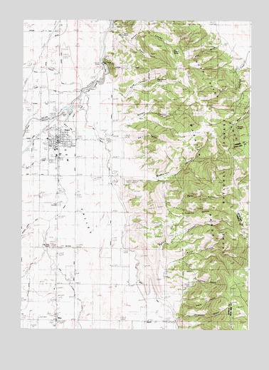
Grace, ID USGS Topographic Map
Click on map above to begin viewing in our Map Viewer.

This topographic map contains these locations and features:
Feature Name Type Latitude Longitude GNIS ID View Map
Allen and Cherry DitchCanalN42.5796°W111.7386°395048View Map
BenchPopulated PlaceN42.5035°W111.6802°396102View Map
Bench A CanalCanalN42.5874°W111.7208°395092View Map
Bench B CanalCanalN42.5810°W111.7247°395093View Map
Bench CanalCanalN42.5302°W111.7355°377344View Map
Bluff HollowValleyN42.6160°W111.6408°395124View Map
Brown DitchCanalN42.5169°W111.7452°395136View Map
Burton CanyonValleyN42.5830°W111.6991°395152View Map
Burton CreekStreamN42.5827°W111.6983°378574View Map
Caribou County Emergency Medical Services GraceBuildingN42.5770°W111.7300°2642832View Map
Christensen CanyonValleyN42.5071°W111.6652°395212View Map
City of GraceCivilN42.5756°W111.7305°2410626View Map
Dry HollowValleyN42.5758°W111.6944°395323View Map
Egbert CanyonValleyN42.5130°W111.6699°381271View Map
Franks CanyonValleyN42.5102°W111.6638°395399View Map
GracePopulated PlaceN42.5760°W111.7305°396575View Map
Grace CemeteryCemeteryN42.5496°W111.7300°382478View Map
Grace DamDamN42.5883°W111.7291°398665View Map
Grace Elementary SchoolSchoolN42.5724°W111.7325°401346View Map
Grace Fire DepartmentBuildingN42.5770°W111.7300°2619166View Map
Grace Junior High SchoolSchoolN42.5696°W111.7313°401477View Map
Grace Post OfficePost OfficeN42.5773°W111.7307°2781742View Map
Grace Senior High SchoolSchoolN42.5702°W111.7313°401348View Map
Hawkins HollowValleyN42.5458°W111.6663°395453View Map
Ice Cave KnollSummitN42.5341°W111.7333°395505View Map
King CanyonValleyN42.5963°W111.6977°395554View Map
King Canyon SpringSpringN42.6015°W111.6766°395555View Map
Last Chance CanalCanalN42.6005°W111.7088°395611View Map
Last Chance DamDamN42.6071°W111.7063°384454View Map
McPherson CanyonValleyN42.5630°W111.6908°386664View Map
Nelson CanyonValleyN42.6208°W111.7019°394821View Map
Nelson CreekStreamN42.6205°W111.7013°387506View Map
Nelson Game EnclosureParkN42.6185°W111.6919°394822View Map
Nelson SpringSpringN42.6124°W111.6675°394823View Map
NiterPopulated PlaceN42.5035°W111.7308°387581View Map
Peterson Hanson DitchCanalN42.5377°W111.7500°394905View Map
Polethief CanyonValleyN42.5130°W111.6655°388703View Map
Right Fork Nelson CanyonValleyN42.6169°W111.6930°395001View Map
Simpson AirportAirportN42.6080°W111.7287°400825View Map
Soda PeakSummitN42.5271°W111.6252°390808View Map
Trouble SpringSpringN42.5389°W111.6251°399329View Map
Water CanyonValleyN42.5255°W111.6691°392933View Map
Water HollowValleyN42.5491°W111.6652°399621View Map
Winchell SpringSpringN42.5817°W111.6326°399664View Map

Note: Coordinates in the location and feature list above are referenced to NAD83 datum.


Copyright (C) 2008-2024 Ryan Niemi / Sunset Dynamics ... All Rights Reserved