TopoQuest Logo
Do you find TopoQuest useful?
Help keep TopoQuest running and adding new maps/features by donating!
Bitcoin:  19c7KJd3qBynnjoSw5npx9KScwjBe4ifkT
Litecoin:  LXs6TkuXGGXo1vDsWCkWVdjQX94eUKd6ui
Home View Maps Find Maps Find Places Resources & Links


Goetzville, Michigan Topographic Map

USGS Map Title: Goetzville, MI
USGS Map MRC: 46084A1
DRG (GeoTIFF) Download: o46084a1.tif


Neighboring USGS Topographic Map Quads:


  Munuscong, MI  
46084B2
 

  Munuscong NE, MI  
46084B1


  Stalwart, MI  
46084A2
 

  Goetzville, MI  
46084A1
 

  Lime Island, MI  
46083A8
 

  Prentiss Bay, MI  
45084H2
 

  Albany Island, MI  
45084H1
 

  De Tour Village, MI  
45083H8


Map MRC Location:

N47°
W85°
N47°
W84°
H8 H7 H6 H5 H4 H3 H2 H1
G8 G7 G6 G5 G4 G3 G2 G1
F8 F7 F6 F5 F4 F3 F2 F1
E8 E7 E6 E5 E4 E3 E2 E1
D8 D7 D6 D5 D4 D3 D2 D1
C8 C7 C6 C5 C4 C3 C2 C1
B8 B7 B6 B5 B4 B3 B2 B1
A8 A7 A6 A5 A4 A3 A2 A1
N46°
W85°
N46°
W84°

Goetzville, MI USGS 1:24K Topographic Map Preview:
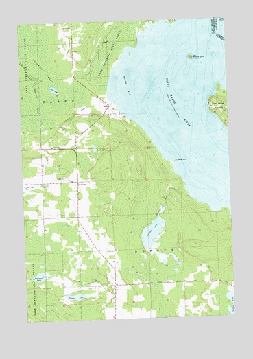
Goetzville, MI USGS Topographic Map
Click on map above to begin viewing in our Map Viewer.

This topographic map contains these locations and features:
Feature Name Type Latitude Longitude GNIS ID View Map
Anderson CemeteryCemeteryN46.1228°W84.0928°620088View Map
Bender LakeLakeN46.0717°W84.0810°1618096View Map
Carlton CreekStreamN46.0522°W84.0270°622733View Map
Carlton LakeLakeN46.0354°W84.0483°622735View Map
Foreman LakeLakeN46.0190°W84.1156°626250View Map
GoetzvillePopulated PlaceN46.0581°W84.0922°626919View Map
Goetzville / Saint Stanislaus CemeteryCemeteryN46.0583°W84.0978°2356458View Map
Goetzville Lookout TowerTowerN46.0570°W84.1134°1623367View Map
Goetzville Post OfficePost OfficeN46.0583°W84.0917°2356311View Map
Karen's Cabins and CampgroundsLocaleN46.0861°W84.0678°2356312View Map
Kirk LakeLakeN46.0968°W84.1043°629764View Map
Lime Island ChannelCanalN46.0703°W84.0172°1618031View Map
Lime Island Post Office (historical)Post OfficeN46.0889°W84.0111°2354358View Map
Lime Island State Forest CampgroundLocaleN46.0883°W84.0111°2354303View Map
Little CemeteryCemeteryN46.0286°W84.0761°630595View Map
RaberPopulated PlaceN46.0892°W84.0714°635584View Map
Raber BayBayN46.0972°W84.0633°635585View Map
Raber PointCapeN46.0659°W84.0325°635586View Map
Raber Post Office (historical)Post OfficeN46.0892°W84.0714°2354329View Map
Raber Township Volunteer Fire DepartmentBuildingN46.0565°W84.0915°2626732View Map
Round IslandIslandN46.1089°W84.0211°636272View Map
Round Island LightLocaleN46.1089°W84.0197°1618098View Map
Saint Stanislaus ChurchChurchN46.0583°W84.0953°637044View Map
Schlesser Post Office (historical)Post OfficeN46.0144°W84.0917°2354323View Map
Township of DetourCivilN46.0031°W84.0048°1626180View Map
WGTQ-TV (Sault Sainte Marie)TowerN46.0517°W84.1111°1625548View Map
WWUP-TV (Sault Sainte Marie)TowerN46.0636°W84.1022°1625547View Map
Ziegler LakeLakeN46.0099°W84.0951°1616927View Map

Note: Coordinates in the location and feature list above are referenced to NAD83 datum.


Copyright (C) 2008-2024 Ryan Niemi / Sunset Dynamics ... All Rights Reserved