TopoQuest Logo
Do you find TopoQuest useful?
Help keep TopoQuest running and adding new maps/features by donating!
Bitcoin:  19c7KJd3qBynnjoSw5npx9KScwjBe4ifkT
Litecoin:  LXs6TkuXGGXo1vDsWCkWVdjQX94eUKd6ui
Home View Maps Find Maps Find Places Resources & Links


De Tour Village, Michigan Topographic Map

USGS Map Title: De Tour Village, MI
USGS Map MRC: 45083H8
DRG (GeoTIFF) Download: o45083h8.tif


Neighboring USGS Topographic Map Quads:


  Goetzville, MI  
46084A1
 

  Lime Island, MI  
46083A8
 

  Burnt Island, MI  
46083A7
 

  Albany Island, MI  
45084H1
 

  De Tour Village, MI  
45083H8
 

  Whitney Bay, MI  
45083H7


Map MRC Location:

N46°
W84°
N46°
W83°
H8 H7 H6 H5 H4 H3 H2 H1
G8 G7 G6 G5 G4 G3 G2 G1
F8 F7 F6 F5 F4 F3 F2 F1
E8 E7 E6 E5 E4 E3 E2 E1
D8 D7 D6 D5 D4 D3 D2 D1
C8 C7 C6 C5 C4 C3 C2 C1
B8 B7 B6 B5 B4 B3 B2 B1
A8 A7 A6 A5 A4 A3 A2 A1
N45°
W84°
N45°
W83°

De Tour Village, MI USGS 1:24K Topographic Map Preview:
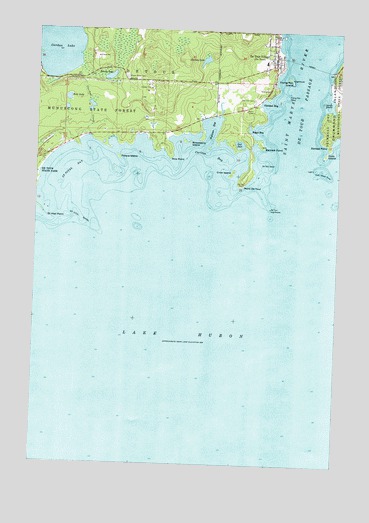
De Tour Village, MI USGS Topographic Map
Click on map above to begin viewing in our Map Viewer.

This topographic map contains these locations and features:
Feature Name Type Latitude Longitude GNIS ID View Map
Barbed PointCapeN45.9695°W83.8806°620578View Map
Bear LakeLakeN45.9801°W83.9873°620864View Map
Bennette PointCapeN45.9672°W83.9069°621119View Map
Bob Hill CemeteryCemeteryN45.9804°W83.9107°621669View Map
Brown LakeLakeN45.9863°W83.9703°622089View Map
Caribou CreekStreamN45.9692°W83.9789°622712View Map
Caribou LakeLakeN45.9969°W83.9937°622716View Map
Carlton BayBayN45.9645°W83.9275°622732View Map
Crab IslandIslandN45.9650°W83.8800°623943View Map
Crab Island ShoalBarN45.9603°W83.8817°623944View Map
Crow IslandIslandN45.9592°W83.9186°624137View Map
De Tour Ambulance ServiceBuildingN45.9909°W83.9022°2662124View Map
De Tour Area Public LibraryBuildingN45.9908°W83.9058°2356339View Map
De Tour Harbor MarinaLocaleN45.9972°W83.8975°1618079View Map
De Tour High SchoolSchoolN45.9908°W83.9058°2356345View Map
De Tour LighthouseLocaleN45.9495°W83.9028°1617976View Map
De Tour PassageChannelN45.9822°W83.8861°624388View Map
De Tour Passage Historical MuseumBuildingN45.9925°W83.8992°2356340View Map
De Tour ShoalBarN45.9628°W83.9047°624389View Map
De Tour VillagePopulated PlaceN45.9945°W83.9028°624391View Map
De Tour Village Medical CenterHospitalN45.9900°W83.9003°2356344View Map
De Tour Village Post OfficePost OfficeN45.9925°W83.9014°2356342View Map
DeTour ReefBayN45.9534°W83.9008°1618076View Map
Detour Volunteer Fire DepartmentBuildingN45.9909°W83.9022°2356343View Map
Drummond Island FerryLocaleN45.9925°W83.8978°2356341View Map
Dummond Dolomite IncorporatedLocaleN45.9842°W83.8761°1618077View Map
Fort Drummond Historical MarkerParkN45.9889°W83.8775°2356420View Map
Freds MarinaLocaleN45.9892°W83.8986°1618078View Map
Frying Pan IslandIslandN45.9864°W83.8947°626544View Map
Frying Pan ShoalBarN45.9817°W83.8967°626546View Map
Gut PortBayN45.9675°W83.9158°627553View Map
Hartley LakeLakeN45.9917°W83.9308°627884View Map
Joe Straw CreekStreamN45.9589°W83.9978°629292View Map
Jones IslandIslandN45.9800°W83.8817°629371View Map
Malette ParkParkN45.9789°W83.9083°2356334View Map
Maple Grove CemeteryCemeteryN45.9864°W83.9628°631444View Map
Olmstad BayBayN45.9797°W83.9061°634040View Map
Orval Lowe Memorial ParkParkN45.9903°W83.8756°2356323View Map
Peters IslandIslandN45.9634°W83.9656°634705View Map
Point De TourCapeN45.9572°W83.9133°635177View Map
Redeemer Evangelical Lutheran ChurchChurchN45.9911°W83.9006°2356335View Map
Rice PointCapeN45.9642°W83.9442°635849View Map
Riverview CemeteryCemeteryN45.9830°W83.9019°2356428View Map
Roggs BayBayN45.9717°W83.9086°636126View Map
Saint Marys RiverStreamN45.9584°W83.8972°1623189View Map
Saint Stephen's Episcopal ChurchChurchN45.9919°W83.9019°2356337View Map
Saint Vital BayBayN45.9597°W83.9842°637090View Map
Saint Vital PointCapeN45.9472°W83.9967°637091View Map
Saint Vital ShoalBarN45.9459°W83.9811°637092View Map
Seymour BayBayN45.9722°W83.9272°637611View Map
Strawberry IslandIslandN45.9681°W83.9381°638942View Map
Village of De Tour VillageCivilN45.9858°W83.9062°2398696View Map
Wilderness Tabernacle ChurchChurchN45.9994°W83.9156°2356338View Map

Note: Coordinates in the location and feature list above are referenced to NAD83 datum.


Copyright (C) 2008-2024 Ryan Niemi / Sunset Dynamics ... All Rights Reserved