TopoQuest Logo
Do you find TopoQuest useful?
Help keep TopoQuest running and adding new maps/features by donating!
Bitcoin:  19c7KJd3qBynnjoSw5npx9KScwjBe4ifkT
Litecoin:  LXs6TkuXGGXo1vDsWCkWVdjQX94eUKd6ui
Home View Maps Find Maps Find Places Resources & Links


Glennville SW, Georgia Topographic Map

USGS Map Title: Glennville SW, GA
USGS Map MRC: 31081G8
DRG (GeoTIFF) Download: o31081g8.tif


Neighboring USGS Topographic Map Quads:


  Tison, GA  
31082H1
 

  Glennville, GA  
31081H8
 

  Glennville NE, GA  
31081H7
 

  Altamaha SE, GA  
31082G1
 

  Glennville SW, GA  
31081G8
 

  Glennville SE, GA  
31081G7
 

  Odum, GA  
31082F1
 

  Jesup NW, GA  
31081F8
 

  Doctortown, GA  
31081F7


Map MRC Location:

N32°
W82°
N32°
W81°
H8 H7 H6 H5 H4 H3 H2 H1
G8 G7 G6 G5 G4 G3 G2 G1
F8 F7 F6 F5 F4 F3 F2 F1
E8 E7 E6 E5 E4 E3 E2 E1
D8 D7 D6 D5 D4 D3 D2 D1
C8 C7 C6 C5 C4 C3 C2 C1
B8 B7 B6 B5 B4 B3 B2 B1
A8 A7 A6 A5 A4 A3 A2 A1
N31°
W82°
N31°
W81°

Glennville SW, GA USGS 1:24K Topographic Map Preview:
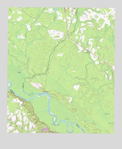
Glennville SW, GA USGS Topographic Map
Click on map above to begin viewing in our Map Viewer.

This topographic map contains these locations and features:
Feature Name Type Latitude Longitude GNIS ID View Map
Beards BluffCliffN31.7919°W81.9576°310956View Map
Beards Bluff Ferry (historical)CrossingN31.7891°W81.9562°352883View Map
Beards CreekPopulated PlaceN31.8663°W81.8854°331113View Map
Beards CreekStreamN31.7894°W81.9640°354503View Map
Beaverdam School (historical)SchoolN31.8391°W81.9184°348150View Map
Black SwampSwampN31.7685°W81.8829°354753View Map
Central School (historical)SchoolN31.8222°W81.8873°348153View Map
Cherokee LakesReservoirN31.7552°W81.9521°312611View Map
Cherokee Lakes Dam WestDamN31.7502°W81.9432°338529View Map
Delbos BayStreamN31.8383°W81.9762°313432View Map
Ebenezer ChurchChurchN31.8749°W81.9248°313824View Map
Grace ChurchChurchN31.8360°W81.9082°348158View Map
Hog LakeSwampN31.8266°W81.9965°347413View Map
Howard Chapel School (historical)SchoolN31.8244°W81.8921°348162View Map
Kicklighters PondReservoirN31.8732°W81.9439°341358View Map
Kicklighters Pond DamDamN31.8719°W81.9432°341357View Map
Lumber Bridge (historical)BridgeN31.8466°W81.9312°347423View Map
Marrowbone RoundBendN31.7522°W81.9257°317709View Map
Mitchell LakeSwampN31.7808°W81.9596°350587View Map
Mushmelon CreekStreamN31.8052°W81.9751°319177View Map
New Hope ChurchChurchN31.7635°W81.9943°319379View Map
New Hope School (historical)SchoolN31.7638°W81.9951°350592View Map
NoblePopulated PlaceN31.8466°W81.9290°348175View Map
Padgett CemeteryCemeteryN31.8383°W81.9946°320151View Map
Pigott Branch ChurchChurchN31.8316°W81.9054°320510View Map
Stafford LakeLakeN31.8105°W81.9846°323496View Map
Stooping Gum IslandIslandN31.8099°W81.9993°347442View Map
Strickland BightBendN31.7597°W81.9426°323675View Map
Tar LandingLocaleN31.7833°W81.9812°350607View Map
Toms CreekChannelN31.7647°W81.9293°324221View Map
Yankee ReachChannelN31.7530°W81.9107°325600View Map

Note: Coordinates in the location and feature list above are referenced to NAD83 datum.


Copyright (C) 2008-2024 Ryan Niemi / Sunset Dynamics ... All Rights Reserved